We are pleased to announce the availability of an update to the World Population Estimate layers.
- World Population Estimate 2016
- World Population Estimate Density 2016
- World Settlement Score 2016
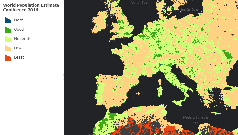
- World Population Estimate Confidence 2016
This update was produced during 2017, using the most current data sources for population and land cover. The significant improvements are highlighted below, and for more detailed information see the 2016 Methodology White Paper:
- A confidence score (1 = most, to 5 = least) surface is now available. This score accounts for the reliability, age, and method of the population estimates, the impact of raster resampling during the modeling process, and the ratio of the population to the size of reporting units. See World Population Estimate Confidence 2016
- The geoprocessing model used to create the surfaces was restructured to eliminate statistical artifacts which affected the model’s ability to determine an appropriate threshold for human settlement, especially in coastal areas. To improve upon this previous version we switched to a Top of Atmosphere (TOA) corrected Landsat8 panchromatic dataset. TOA effectively normalizes statistics between scenes.
We are also pleased to include that Esri participates in the POPGRID Data Collaborative, which is a consortium of those who produce global and national gridded population estimates and redistributions. POPGRID seeks to facilitate collaboration among data producers and inform users about the differences in purpose and utility of existing gridded population datasets.
The 2016 World Population Estimate layers are found in the ArcGIS Living Atlas of the World.
Supporting Content:
-
- 2016 Methodology White Paper that provides detailed documentation describing the nature of the WPE, how it is produced, and recommendations for successful use.
- World Population Estimate 2016 Sources Web Map
- We are Everywhere story map that introduces the WPE and possibilities for gridded population data.

Commenting is not enabled for this article.