Any organization with global reach needs to understand what part of its operations are in sunlight, darkness, or twilight. Which of your fleet vehicles are operating in sunset conditions right now? When will the Sun go down on your warehouses, affecting your cooling energy use and solar energy production? How many more hours until the Sun is up in that time zone?
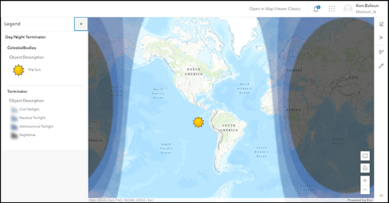
Day/Night Terminator is a new layer item in ArcGIS Living Atlas that lets users include a visualization of the current day/night cycle in their maps and apps. Day/Night Terminator is updated every 10 minutes using the Esri Live Feeds Methodology and computes the approximate location of the Sun, perpendicular to the planet, using the current UTC date and time.
Watch as the Sun, Day/Night Terminator, and horizon pass over your map, highlighting what areas are in dusk, darkness, and dawn.
Dawn and dusk
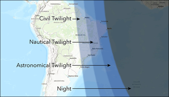
Twilight, also known as dawn and dusk, is the visible reflective light in the atmosphere as the Sun dips below (dusk) or approaches (dawn) the horizon. Three stages of twilight are classified at six degree increments, producing various shades of darkness and vibrant colors.
Civil twilight is the first stage as the Sun moves below the horizon (dusk) or the last as the Sun approaches the horizon (dawn). Enough natural light exists for people to see without needing artificial light. Celestial objects are not yet visible.
Nautical twilight is the second stage. Artificial light is now helpful and celestial objects can be seen with ease. Ships find it difficult to navigate by the horizon.
Astronomical twilight is the last stage before darkness sets in. Only distant clouds are a glow on the horizon with bright stars in full view.
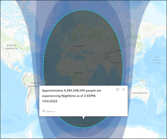
Population in twilight or darkness
Terminator polygons include a geoenriched attribute containing the approximate total population experiencing twilight or darkness.
Uses for Day/Night Terminator
A continually updated visual representation of this daily cycle provides an additional source of information for planners and decision makers that operate in an environment that is impacted by the day/night cycle. This may include logistics and fleet management, maritime, law enforcement, as well as other first responders who are engaged in search and rescue operations where daylight is critical to mission execution.
More information
You can learn more about the Esri Live Feeds Methodology mentioned above or view existing live feeds that may be useful in your maps and apps. For more information, see:
- Day/Night Terminator item
- ArcGIS Living Atlas
- ArcGIS Living Atlas Live Feeds group
- Esri Live Feed Community
About the author


Commenting is not enabled for this article.