CHALLENGE
For airports, every day is a mission; from daily operations to unplanned events, a level of location-based situational awareness is required that only ArcGIS can provide. An ever-present concern for airports, extreme weather events are becoming routine. When an airport is prepared and ready to respond to these events, they are more prepared to protect the safety and security of visitors and staff who use the airport. With all the intricacies of day-to-day airport operations, it is no small feat to plan, practice, and execute emergency plans that incorporate onsite and off-site emergency staff that respond to severe weather. To protect an airport’s critical infrastructure, facility managers are using operational intelligence technology and a geographic approach to provide an all-inclusive, real-time command–and–control solution to streamline daily operations, plan emergency operations, allocate resources, communicate with staff, and playback operations for accountability and optimization of future operations.
SOLUTION
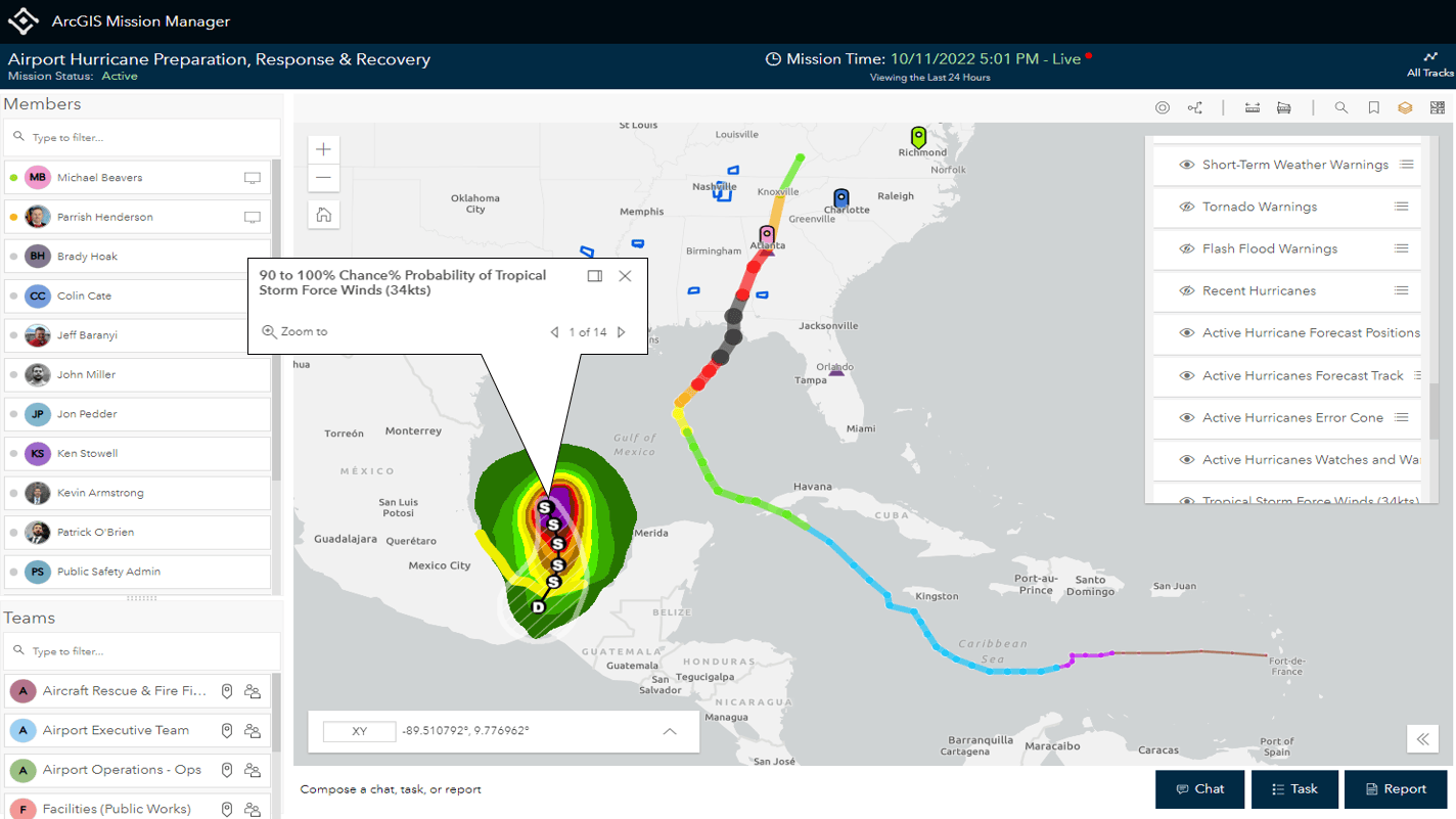
ArcGIS Mission enables airports to prepare, respond, and recover from extreme weather events, like hurricanes, using location-based technology that helps save time and properly allocate resources in urgent situations. Preparing staff at an airport requires a holistic view of emergency protocols and logs of facility vulnerabilities like flood risk areas and infrastructure in need of maintenance. With ArcGIS Mission Manager (ArcGIS Mission’s web component) you can activate a mission at the start of Hurricane season that includes live weather and other dynamic data feeds as well as important operational information, like emergency protocol PDFs, for easy access by your staff in the Mission Responder app (ArcGIS Mission’s mobile component.)
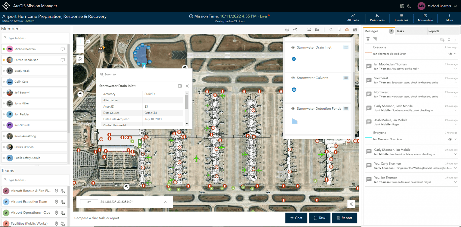
In this Mission, airport operations staff (Ops) report facility vulnerabilities directly from their mobile phone, with Mission Responder, while performing their day-to-day work. Through a custom maintenance report, staff can include details and images of the area that requires maintenance. Meanwhile, back in the operations center, managers will see all submitted reports pinned directly on the Mission map along with other details including who submitted it and their locations in real-time. Additionally, supervisors can use this tool to communicate with team members directly via secure chat if additional information is needed to complete the maintenance request. Once Ops is ready to request maintenance, they can use Mission Manager to assign a task to the maintenance team members on duty referencing the report submitted. When the maintenance worker receives notification of the task, they can locate where they are needed via the mission map and follow up with the operations manager via chat.
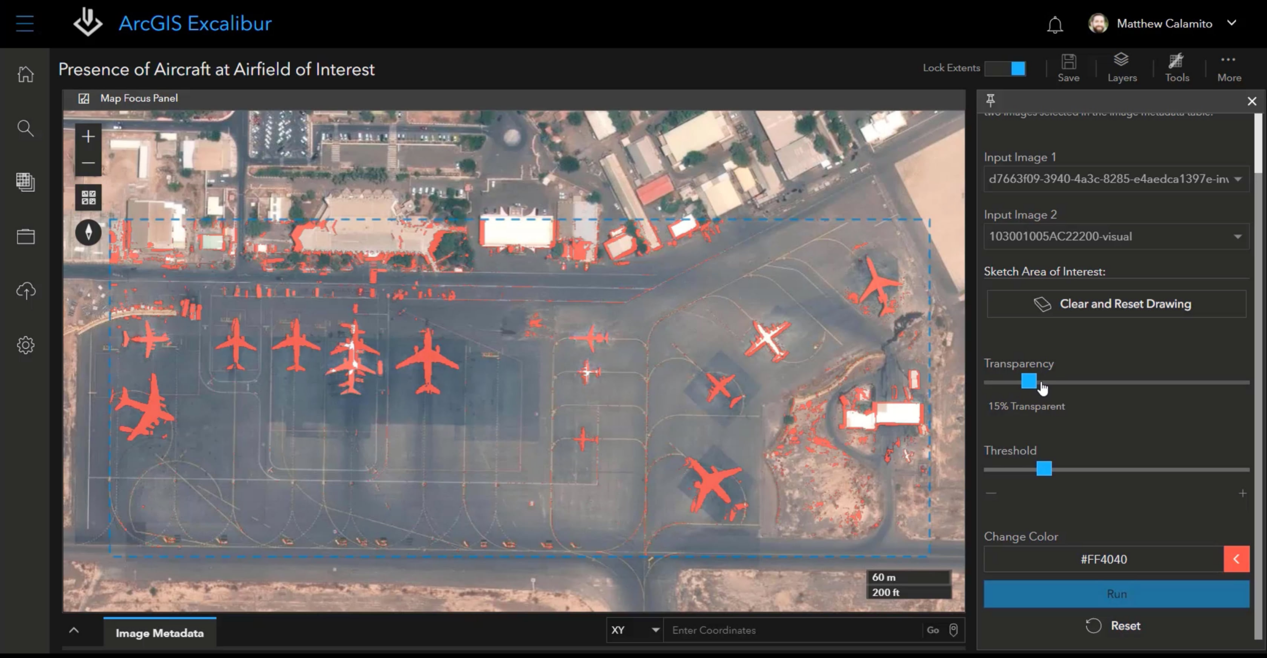
Preparing your staff and facility for emergencies will enable a faster response in the event they occur. The Airside encompasses a large geographic area and needs to be monitored and maintained by airport operations to mitigate delays before and after a hurricane. Utilizing drones, Ops can cover more ground in far less time and send imagery processed with SiteScan for ArcGIS back to Operations for analysis. With updated imagery, the Ops team can use change detection in ArcGIS Excalibur to track the presence of aircraft that may have shifted during extreme weather of the markup feature to identify areas of the airport where fortification, or other maintenance, could be necessary to harden facilities against hurricanes. Inside your facility, Mission can help plan evacuation routes, identify shelter-in-place capabilities that can be notated on your mission map, and facilitate multi-agency communication and coordination, live weather data visualization, employee locations and tracks, and other live operational data layers on your Mission map.
“In disaster, an airport can substitute for almost anything else, but nothing can substitute for an airport.”
A critical component of transportation infrastructure, it is essential for airports to restore operations quickly after a hurricane. ArcGIS Mission enables you to recover faster by pulling in operational data, like imagery, into Mission Manager to aid in assessing facility damage after a hurricane. The airport Operations team can integrate drone imagery of your airport before and after a hurricane to identify and assess damage that was sustained during the storm. The imagery and mark-up layers can then be integrated into ArcGIS Mission to serve as a guide for the airport operations manager to create tasks and deploy staff to collect additional information and images. Using custom tactical summary reports and forms within the Responder app, staff can report the level of damage to affected areas across the airfield. This data can then be exported into ArcGIS Dashboards and other external file formats. This workflow, with ArcGIS Mission at the center, can help Ops Managers collect detailed information quickly to submit requests for assistance and reimbursement from the Federal Emergency Management Agency (FEMA) to keep operations up and running when your Airport needs it most.
BENEFITS
ArcGIS Mission simplifies protecting your critical infrastructure by integrating data most important to your operations in one common operating picture. Prepare your staff and facility with dynamic, interactive mission planning, practice exercises, and scalable operations support with the ability to have multiple missions running independently and privately. Respond to emergencies utilizing real-time situational awareness, secure peer-to-peer communication, field reporting, tasking, and sensor integration. Recover quickly from extreme weather events by capturing your operational data in a secure, dedicated server for After Action Review (AAR), conduct post operation analysis of damage, learn patterns for future training exercises, and provide necessary data to get the assistance you need to be fully operational again.
LEARN MORE
To learn more about using ArcGIS Mission for airport operations, and to contact sales, visit the ArcGIS Mission page. To learn more about using ArcGIS for Operational Intelligence and sign up for more news like this, visit the page.
White, Walter (2007). Aviation Critical Infrastructure, Airports & Catastrophes [PowerPoint slides]. American Public University System. https://training.fema.gov/hiedu/09conf/report/smith-catastrophicfailures-aviationcriticalinfrastructureairportsanddisaster.ppt


Article Discussion: