Parquet feature layers were introduced to ArcGIS Online in Beta in June 2026 as a new way to visualize and share large, read-only datasets. Built on the scalability and performance benefits of Parquet, these layers enable organizations to bring large volumes of data into ArcGIS Online through ArcGIS Data Pipelines and use them in maps and applications.
The November 2026 update builds on that foundation with new capabilities now available in ArcGIS Online. Enhancements include support for date and time fields, time series visualization in Map Viewer, charts, refresh intervals, and saving layer configurations. The update also expands application support and introduces a new Parquet collection export format for analytics and data engineering workflows. Together, these enhancements make Parquet feature layers easier to use across the ArcGIS platform, allowing organizations to integrate large datasets into familiar workflows for mapping, sharing, and decision-making.
Parquet feature layer enhancements
Parquet feature layers include several enhancements that expand the types of data and workflows they can support. They also provide more ways to work with and manage the layer directly from its item page.
- Support for more fields – Feature services have a 1,024-field limit, while Parquet feature layers can support larger schemas. This allows datasets with large numbers of attributes to be used without reducing the schema.
- Expanded date and time support – Parquet feature layers now support Parquet date and time types and convert them to corresponding Esri field types. They also support Esri date and time field types, except timestamp offset fields. Timestamp offset fields do not have an equivalent Parquet field type. Timestamp offset fields can be removed or converted to a supported field type using ArcGIS Data Pipelines tools.
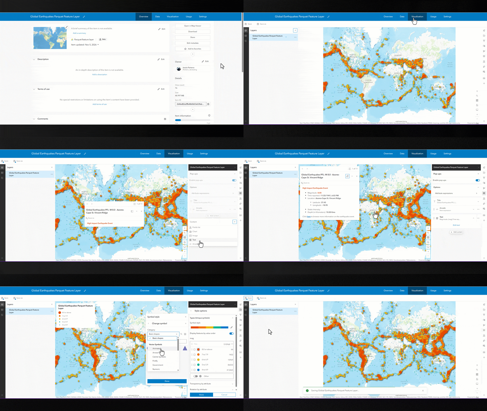
- Save layer configurations – You can now save layer configurations with the Parquet feature layer and reuse them across maps. Saved configurations include symbology, filters, effects, aggregation, pop-ups, fields, labels, charts, blending, transparency, visible range, time series, and refresh interval, allowing the configured layer to be reused across maps. Save is available in Map Viewer and from the Visualization tab on the item page.
- Save as a new item – Save As creates a new layer item with its own saved configuration, but the Parquet data is not copied to the new item. The new item continues to reference the data from the source Parquet feature layer. The source layer must therefore be shared with the same users or groups for them to access the data. Save is available in Map Viewer and from the Visualization tab on the item page.
- Data tab – Review the layer’s table and fields directly from the item page without opening the layer in Map Viewer. The table and schema are read-only.
- Visualization tab – View the spatial data and configure the layer directly from its item page. Save configuration changes to the existing Parquet feature layer or use Save As to create a new Parquet feature layer item.
Map Viewer support
Some of the biggest enhancements to Parquet feature layers are in Map Viewer. These updates provide more ways to visualize, explore, and interact with your data, while giving you greater control over how Parquet feature layers are configured and saved.
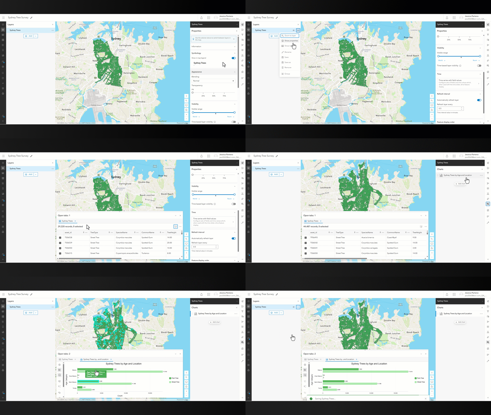
- Time series – Parquet feature layers now support time-enabled mapping, allowing you to visualize, filter, and animate temporal datasets to explore how patterns change over time. For more information, see Configure time settings.
- Charts – Create bar, line, pie, and histogram charts from Parquet feature layers, providing additional ways to explore and understand the information in the layer. Configure charts
- Refresh interval – Set a refresh interval from 6 seconds to 24 hours to automatically display updates to a Parquet feature layer as they become available. This is especially useful when a scheduled pipeline updates the layer. Set refresh interval
- Relative time filters – Parquet feature layers now support relative time filters, allowing you to filter features based on a rolling time period, such as showing features from the last 6 hours based on a selected time field. Set the filter once, and the results update automatically as time progresses without needing to change the filter. Filter expressions
- Layer information – Layer information is now available in the properties pane in Map Viewer. You can also open the Parquet feature layer item directly from Map Viewer.
- Save and Save As – Save layer configuration changes to the existing Parquet feature layer or use Save As to create a new Parquet feature layer item directly from Map Viewer. Save and duplicate layers
Application Support
Support across ArcGIS applications provides more ways to interact with Parquet feature layers and get information from the data. Parquet feature layers can now be used as reference layers in maps across supported apps. Additional tools and capabilities are available depending on the application. Support continues to expand, with additional capabilities planned for future releases.
- Instant Apps – Parquet feature layers work with supported tools and components in Atlas, Basic, Compare, Indicator, Nearby, Portfolio, Sidebar, and Zone Lookup apps.
- ArcGIS Dashboards – Several components and capabilities work with Parquet feature layers, including lists, details, data sources, and interactive map tools.
- ArcGIS Experience Builder – Current support focuses on map functionality, including pop-ups and labels.
- ArcGIS Hub – Support for Parquet feature layers is planned for the first release of 2027.
Putting Parquet feature layers to work
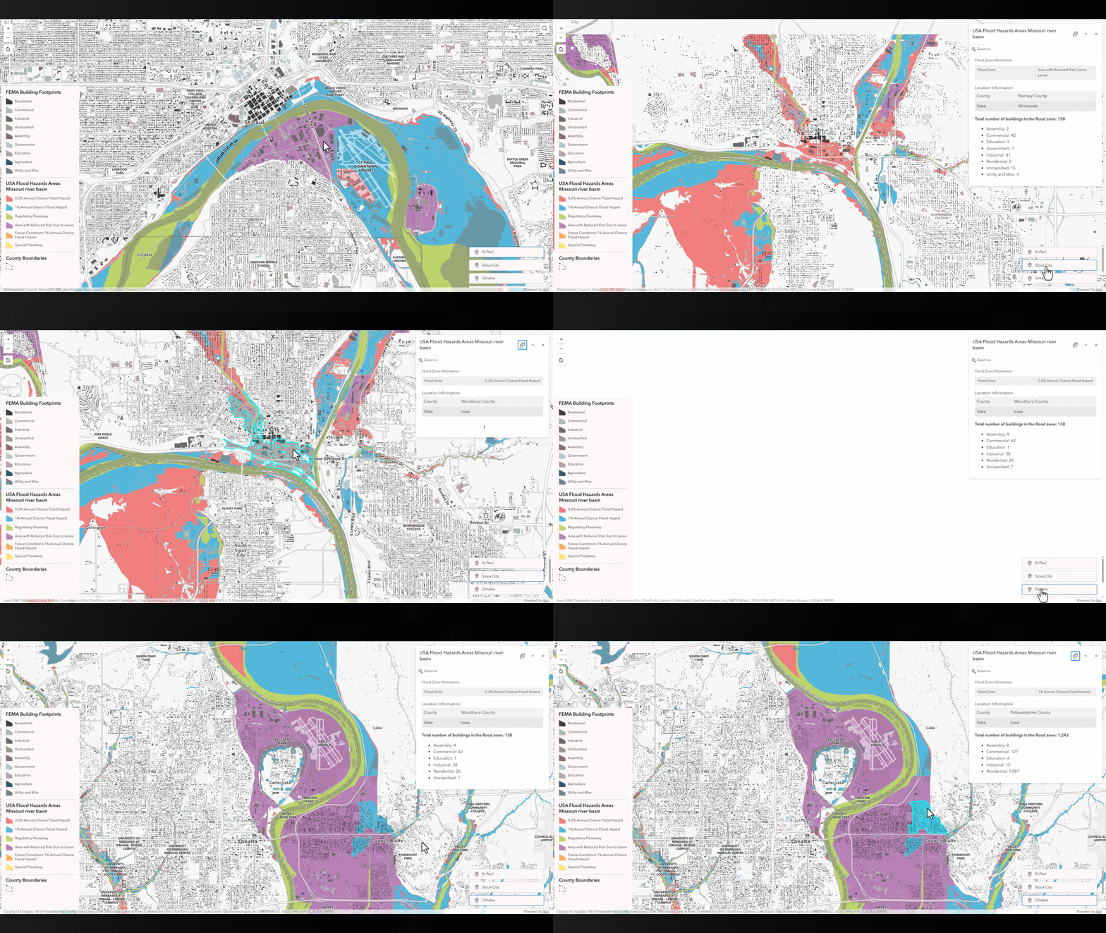
Even when every tool or widget in an application does not yet support Parquet feature layers, they can still provide a strong foundation for working with large datasets in an app. Users can quickly navigate to high flood threat areas and select a flood zone to see its county and state. They can also see the total number of buildings and a breakdown by type, providing a quick view of the potential impacts in that area.
The example below combines three Parquet feature layers: more than 100 million FEMA building records, Missouri Basin flood zones, and county boundaries. Users can quickly navigate to high flood threat areas and select a flood zone to see its county and state, along with the total number of buildings and a breakdown by type, providing a quick view of the potential impacts in that area.
New Parquet collection
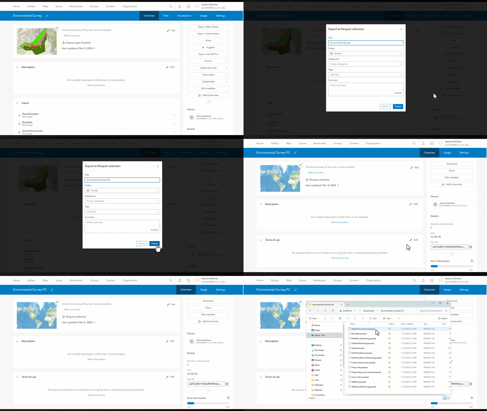
ArcGIS Online now includes Parquet collection as an export option for hosted feature layers and tables. A Parquet collection contains Apache Parquet files packaged in a zipped folder. When a hosted feature service contains multiple layers or tables, each layer and table is exported as a separate .parquet file within the collection. The Parquet files are not spatially optimized like those used with Parquet feature layers, but they provide an efficient way to store and process large volumes of data. Parquet uses Snappy compression, which can help reduce storage requirements.
This export format provides another way to move large volumes of geographic data between ArcGIS and cloud-native data storage and incorporate them into data lake workflows. Parquet collections can also be filtered as an item type in ArcGIS Online.
How to create a Parquet collection
- Open the item page of a hosted feature layer that you have permission to export to a different format.
- Click Export data.
- Choose Export to Parquet Collection.
- Enter the title and any other required item details.
- Click Export to create the Parquet collection.
- Once the export finishes, download the Parquet collection file.
Existing limitations
While support for Parquet feature layers continues to expand, there are some current limitations to consider when using them in your workflows. Support for these capabilities is planned for future updates. These limitations can help determine where Parquet feature layers are a good fit today and where another layer type may be more appropriate.
- No offline support: Parquet feature layers cannot be taken offline or used in disconnected workflows.
- Pop-ups: Arcade expressions using the FeatureSet() functions may not perform well with large datasets.
- Coordinate systems: All Parquet feature layers store spatial data in WGS 1984 in this release. As a result, they can only be used with Web Mercator or WGS 1984 basemaps.
- Created and updated using ArcGIS Data Pipelines: Parquet feature layers can only be created and maintained using ArcGIS Data Pipelines in the June 2026 update to ArcGIS Online.
- Cannot be used in the Analysis tools in the Map Viewer: Parquet feature layers cannot be used as inputs to the analysis tools in Map Viewer at this time.
Inherent limitations
- Read-only:Data cannot be edited directly. If the data needs to be updated, the layer can be overwritten.
- Web clients:Parquet feature layers can be used in apps that use the latest version of the ArcGIS Maps SDK for JavaScript.


Article Discussion: