Timber is an important commodity that is used in many aspects of everyday life. Once timber is harvested, it is usually loaded on to log trucks that deliver the timber to a mill where it is transformed into common paper products, lumber, and more. Depending on where the timber was harvested, there could be several mills capable of processing the logs into different products. Selecting the best location to transport logs can be a challenge for commercial forestry companies. Factors such as mill capacity, commodity price, and haul time and distance play a major role in determining which locations are the most economical. ArcGIS has ready-to-use routing and network analysis tools that can be used to estimate transportation costs, visualize haul scenarios, and understand the best options for getting logs to the mill.

Network Analysis in ArcGIS
Network Analysis can be used to model a variety of routing scenarios – like finding the quickest or shortest route between two locations, identifying the nearest location to a source, or generating travel times and distances from origins to destinations. Analysis is performed on an underlying network of connected roads called a network dataset. Therefore, accurate road data is the most important factor in any routing workflow. Quality road data can be difficult to find at the resolution or format needed to perform analysis. Other commercial routing and navigation applications include good quality road data but have limited analysis options and lack configurability to meet specific needs.
ArcGIS Online provides a high-quality road network and ready-to-use analysis tools that are designed specifically for routing workflows. With ArcGIS Online, there is no need to download road data or create your own road network. Hosted routing services enable you to perform analysis from a variety of desktop, web, and mobile applications and only requires an internet connection to do so.
Routing Considerations
Log trucks are often subject to certain travel restrictions or requirements that may limit which roads they can travel on. In many rural areas, small bridges and roads have height or weight restrictions. A fully loaded log truck can easily exceed the overhead clearance or weight limit. In more populated areas, companies may qualify for exemptions by avoiding certain types of roads or developed areas. Incorporating these considerations into a routing analysis can prevent safety risks and reduce costly mistakes, like having to turn around or back track.
The road data in ArcGIS Online includes attributes and parameters for modeling travel restrictions. Custom travel modes can be configured to reflect travel requirements and restrictions that log trucks must obey. For example, a custom travel mode can be created for log trucks that avoid roads with weight restrictions of 50,000 lbs or more, height restrictions of 12 ft or more, and prefer designated truck routes. Travel modes are specified when routing analysis is performed so the results are reflective of the rules configured.
Not all travel considerations are baked into the road data. Some events, like load-zoned bridges or damaged roads may exist and are managed independently of the road network. When you run an analysis tool, you can specify locations – also known as barriers – that need to be avoided for one reason or another. Features can be drawn directly on the map at the time of analysis or loaded in as a layer. The solver will find the least-cost path between the origin and destination that avoids the barrier features. Barriers can provide flexibility for modifying how routes are generated and can result in more accurate travel times and distances. Barrier features can be saved and persisted as a layer for use in future analysis.

Network Analysis in ArcGIS Online consumes credits. The number of credits used depends on the type of analysis you are performing. See Understand Credits for more information. If you don’t want to be limited by credits, the same analysis tools are available in ArcGIS Pro with the Network Analyst extension. If you choose to use Pro, you will need a road dataset to run against. ArcGIS StreetMap Premium provides enriched street data designed specifically for use in ArcGIS. StreetMap Premium includes a ready-to-use network dataset for analysis, along with geocoding and high-quality map display.
Many forestry organizations manage their own network of private forest roads. If the hosted road data in ArcGIS Online or StreetMap Premium isn’t detailed enough, you have the ability add in your own road features. StreetMap Premium Custom Roads is a special product that allows you to integrate your roads with the StreetMap Premium roads to generate a comprehensive, seamless road network that can be used for analysis.
Common Workflows
An average harvesting operation can produce dozens of truckloads of logs. A company may haul their own logs to the mill or contract it out to a 3rd party. The cost to haul timber primarily depends on the travel time and distance from the harvest to the mill. Finding the shortest or quickest route can reduce transportation costs, increase the number of trips a truck can make, and reduce unnecessary wear and tear on equipment.
Let’s look at some common workflows using the hosted routing services in ArcGIS Online.
Point-to-Point Routes
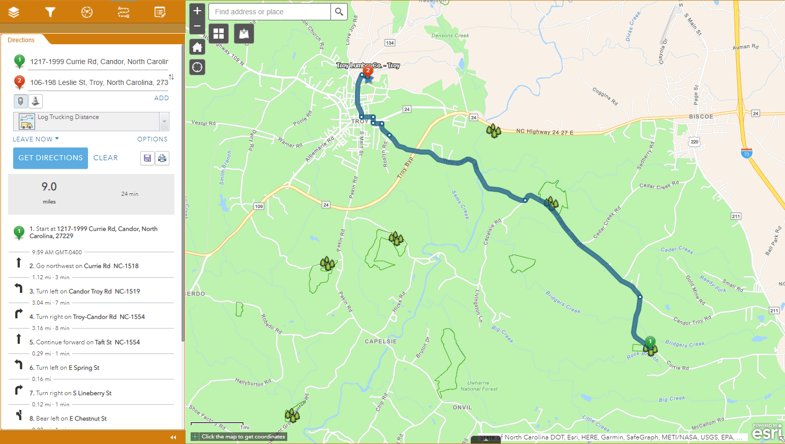
When you want to find the shortest or quickest route between a single harvest and single mill, use the Get Directions tool. The result will be the least-cost path between the two locations. You can set the travel mode, add restriction barriers, and even factor in traffic conditions. Once directions are created, you can make changes to the route and save the route as a layer.
Closest Facility Routes
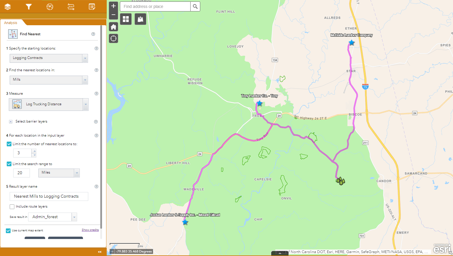
In some cases, there may be multiple mills in an area. The best mill to haul logs to may not always be a clear choice. The Find Nearest tool can be used to find the nearest mill to the harvest location. The near distance can be based on a straight-line distance or use travel time or driving distance as the measure. The tool can also be used to find a specified number of locations within a given distance and rank them based on proximity.
Bulk Routes
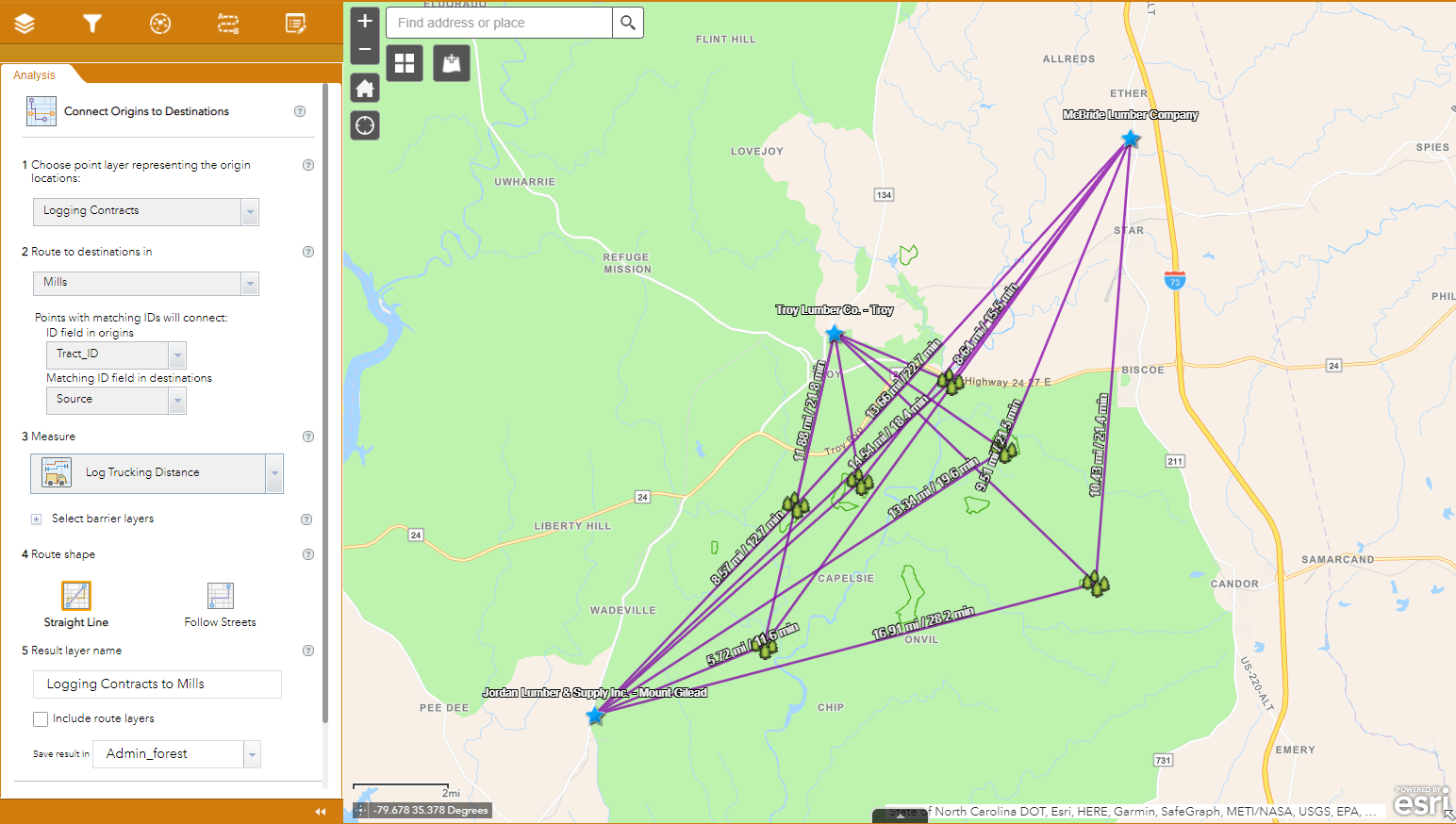
When you are planning timber harvests or evaluating timber sales, you may be interested in understanding all possible haul scenarios. Estimating transportation costs for each origin-destination pair is important to determine the best option. The Connect Origins to Destinations tool can be used to generate drive times and distances from multiple origins to multiple destinations.
Sharing the Results
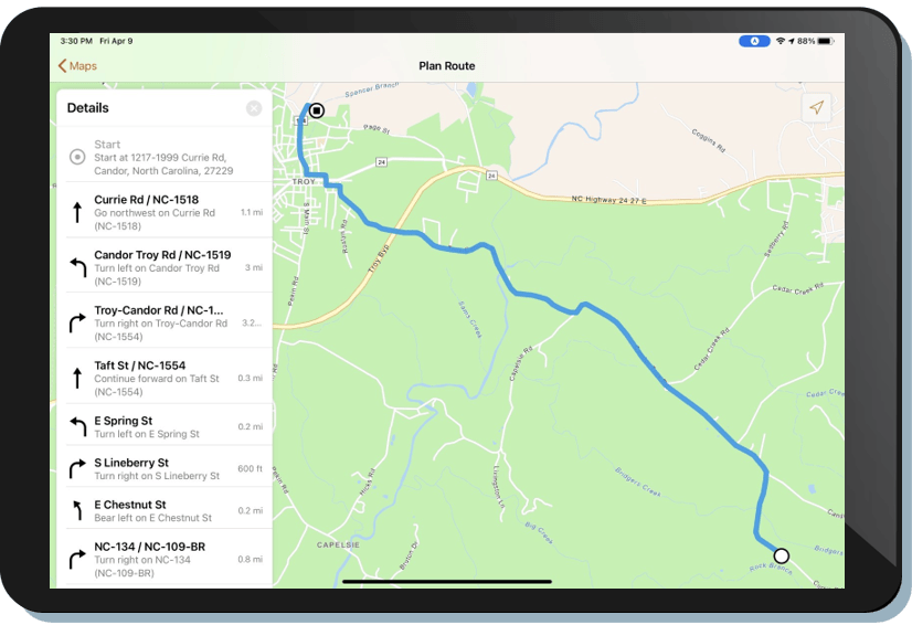
Results from network analysis tools are stored as new layers in ArcGIS Online by default. These layers can be added to maps for visualization, shared with others, or archived for recordkeeping. In some cases, you may want to share routes with field workers to provide guidance. Instead of sending or printing off directions, you can share the output of your analysis directly. Route Layers are a special type of item that include all the information for a particular route, such as stops and travel directions. Route Layers can be used in ArcGIS Navigator to provide drivers with turn-by-turn directions and voice guidance in both connected and disconnected environments.
Summary
ArcGIS includes a robust set of network analysis tools that can help streamline forestry logistics planning and execution. Ready-to-use data and services provide a standardized way to generate optimized routes and driving directions quickly and easily. Decision support tools allow you to better understand potential costs and allocate resources appropriately. Transform your log supply chain today with ArcGIS.


Article Discussion: