One of the tricky aspects of DEM production from lidar is related to the representation of water. It’s desirable for lakes and reservoirs to be flat, and for larger rivers to be level from bank to bank while also only flowing downward, never up. The enforcement of this behavior is commonly referred to as ‘hydro-flattening’. It’s done for cartographic, or aesthetic, purposes. Hillshades and contours, for example, will look and behave as expected when made from DEMs that have been properly hydro-flattened. Lakes and reservoirs are relatively easy to handle because they just get completely flattened. Rivers are where the greater challenge lies because they need to flow downslope, naturally following the surrounding terrain.
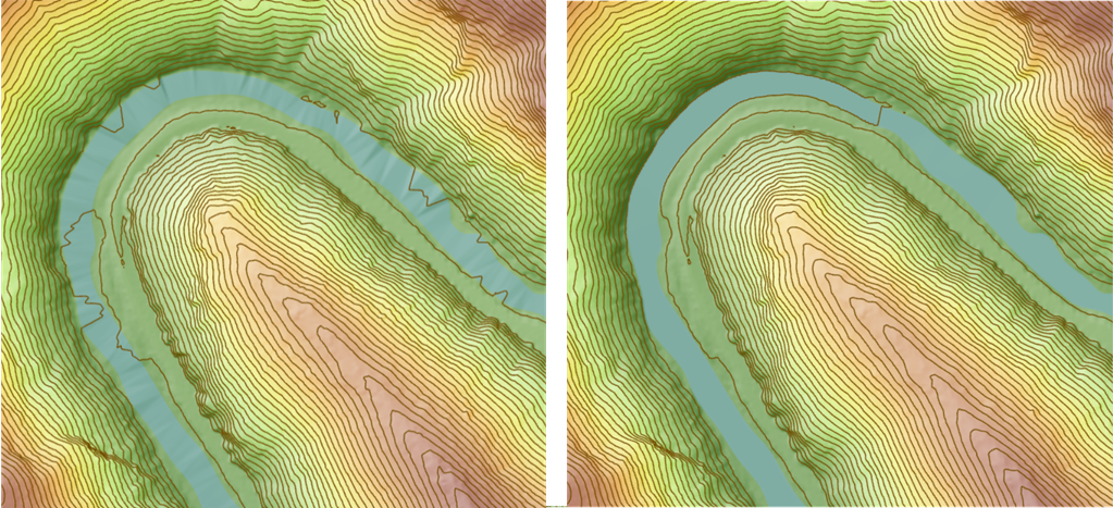
Color hillshade and contours made from untreated DEM on left, results from hydro-flattened DEM on right.
In ArcGIS Pro 3.0, the 3D Analyst extension introduces a new geoprocessing tool that facilitates hydro-flattening of river shorelines. It’s called Enforce River Monotonicity. It ensures river heights, usually obtained from lidar, always go in one direction (i.e., down) which is why the word ‘monotonicity’ is used; it’s uni-directional in Z. It also ensures the bank-to-bank height is consistent. The tool is a key piece of a larger workflow to make high quality DEMs.
General workflow for creating hydro-flattened DEMs from aerial lidar data using a LAS dataset:
- Obtain 2D polygons that represent larger rivers. For this workflow, larger rivers are those which average 30 meters or more in width. Sources for these polygons are varied. They can come from classified multi-spectral imagery (best captured at same time as lidar) or from previously compiled map data. For example, in the United States, there’s the National Hydrography Dataset, specifically NHDPlus HR. Water body polygons are usually represented as 2D features. These 2D features will be used to create 3D features.
- Classify ground points.
- Classify flight line overlap points so they can be filtered out, leaving the remaining points with a more consistent point density (optional).
- Classify ground points. Water may get (mis)classified as ground at this point. That’s okay.
- Reassign any ground classified points that fall inside the river polygons to water. Don’t include class 1 points in this step because these can represent overhanging vegetation, or other above ground feature, which you do not want classified as water.
- Use ground height values from the lidar data to create initial 3D water polygons. This can be accomplished using the Interpolate Shape tool with the option to ‘conflate nearest z’ when the input lidar is filtered to ground. The resulting polygons will likely have heights that go up and down along the path of the river. This can happen because of dense vegetation along the shoreline that reduces lidar ground sample density. Rocks and cliffs close to shore can also come into play. The 2D position of the polygons themselves are also a bit fuzzy because shorelines aren’t static or constant things. What we need to do is to adjust the undulations, always biasing the shoreline height to the lower lidar ground points found along any given stretch of the river.
- Hydro-flatten the 3D water polygons. Adjust the undulations of the height in the 3D water polygons to ensure that the height decreases along the downstream path of the river and is even from bank to bank. This can be accomplished through the new Enforce River Monotonicity tool.
- Reduce the potential for surface discontinuities near shorelines. Reclassify ground points that are close (e.g., within 1m) to shoreline polygons to class 20 (i.e., ignored ground) because lidar points too close to breaklines can cause undesirable sharp discontinuities in the resulting surface (optional).
- Add the hydro-flattening constraints to the source surface model. Incorporate the 3D lines produced by the Enforce River Monotonicity tool into the LAS dataset as hard breakline surface constraints. You can use the LAS Dataset Properties dialog in Catalog to do this or the Add Files To LAS Dataset tool.
- Produce the final cartographically improved raster surface. Create a DEM using the LAS Dataset To Raster tool with the following:
- Filter the input LAS dataset layer to ground classified points.
- Ensure input the LAS dataset layer 3D river surface constraint is enabled.
- Use the “Triangulation” interpolation type on the tool.
Additional resources:
USGS Lidar Base Specification (pg., 15-22)
Digital Elevation Models, Hydro-Flattening, and Hydro-Enforcement

Commenting is not enabled for this article.