We can’t wait to meet you virtually at the 2020 Esri User Conference! Be sure to register as soon as possible to unlock hours of technical workshops, keynote sessions and more. And, we have so much spatial analysis and data science content we are excited to share with you across the whole conference, catering to users of all levels. The following sections guide you through suggested technical workshops, demo theaters and showcase areas to explore, based on your area of interest.

You can view more details about each of the streaming live workshops below by following the links provided to the online agenda. Once the virtual User Conference platform goes live on July 13th, you’ll be able to view the streaming live and on-demand workshops by searching for their titles in the platform.
Getting Started with Spatial Data Science in ArcGIS
Whether you’re seasoned ArcGIS user who is looking to sharpen your Spatial Data Science skills or a data scientist looking to jump into spatial, here are a few sessions that will give you a good starting point for learning more.
- Streaming Live: Spatial Data Science in ArcGIS
- Streaming Live: Applying Spatial Data Science: A Complete Workflow
- Streaming Live: ArcGIS Notebooks: An Introduction
- Streaming Live: ArcGIS Pro: Analysis and Geoprocessing Overview
- On-Demand: Machine Learning in ArcGIS: An Introduction
- Streaming Live: Using Deep Learning with Imagery in ArcGIS
- Bring your questions to the teams! Search for Spatial Analysis and Data Science in the showcase.
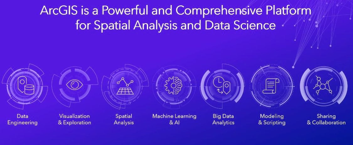
An Overview of Spatial Data Science in ArcGIS
Gain an oversight of all of the Spatial Data Science capabilities in the ArcGIS platform.
- Plenary Session – Part 2 – ArcGIS Technology & Applications
- Streaming Live: Spatial Data Science in ArcGIS
- Streaming Live: Applying Spatial Data Science: A Complete Workflow
- Streaming Live: Data Visualization for Spatial Analysis
- Streaming Live Spatial Analysis and Data Science: Q&A with the Product Team
- On-Demand: ArcGIS Pro: Your Data Science Workstation
- Streaming live: An Introduction to Analysis in ArcGIS Online
- Bring your questions to the teams! Search for Spatial Analysis and Data Science in the showcase.
Python and R in ArcGIS
Automate process and extend functionality using Python, R and other data science packages.
- Streaming Live: Python Across the ArcGIS Platform
- Streaming Live: ArcGIS Notebooks: An Introduction
- Streaming Live: ArcPy: An Introduction
- On-Demand: ArcPy: Building Geoprocessing Tools
- Streaming: ArcGIS API for Python: An Introduction to the Modules
- On-Demand: ArcGIS API for Python: Data Engineering using DataFrames
- On-Demand: ArcGIS API for Python: Performing Spatial Analysis
- On-Demand: The R‐ArcGIS Bridge and R Notebooks: An Introduction
- On-Demand: A Tour of the R‐ArcGIS Bridge
- Postconference seminar (additional fee): Python Scripting for GIS Users
- Postconference seminar (additional fee): Doing Spatial Data Science Using R and ArcGIS
- Bring your questions to the teams! Search for ArcGIS Notebooks, ArcPy, ArcGIS API for Python and R-ArcGIS Bridge in the showcase.
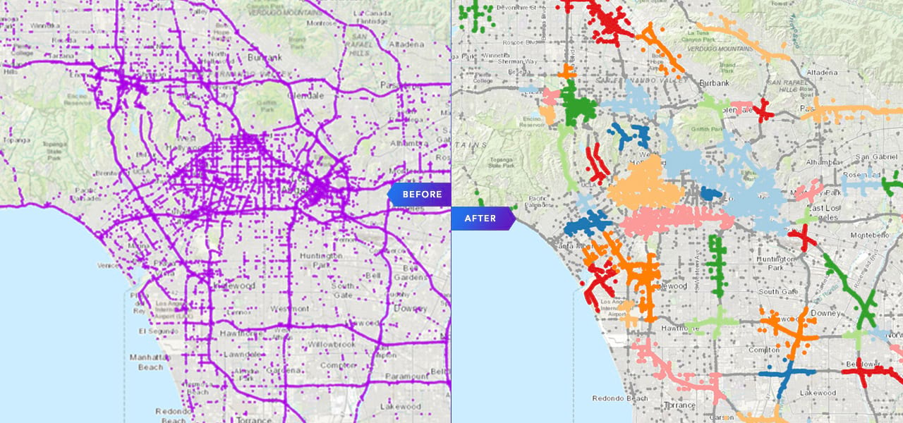
Spatial Analysis in ArcGIS Pro
Go beyond simple map visualizations by integrating location data into your analysis in ArcGIS Pro.
- Streaming Live: ArcGIS Pro: Analysis and Geoprocessing Overview
- Streaming Live: ModelBuilder: Tips and Tricks
- On-Demand: ModelBuilder: Advanced Techniques
- Streaming Live: ArcGIS Pro: Geoprocessing in Parallel Using Apache Spark
- On-Demand: Use Anything Other Than Web Mercator!
- Bring your questions to the teams! Search for Geoprocessing, ModelBuilder, Charts, Geometry Engine, Coordinate Systems and GeoAnalytics in the showcase.
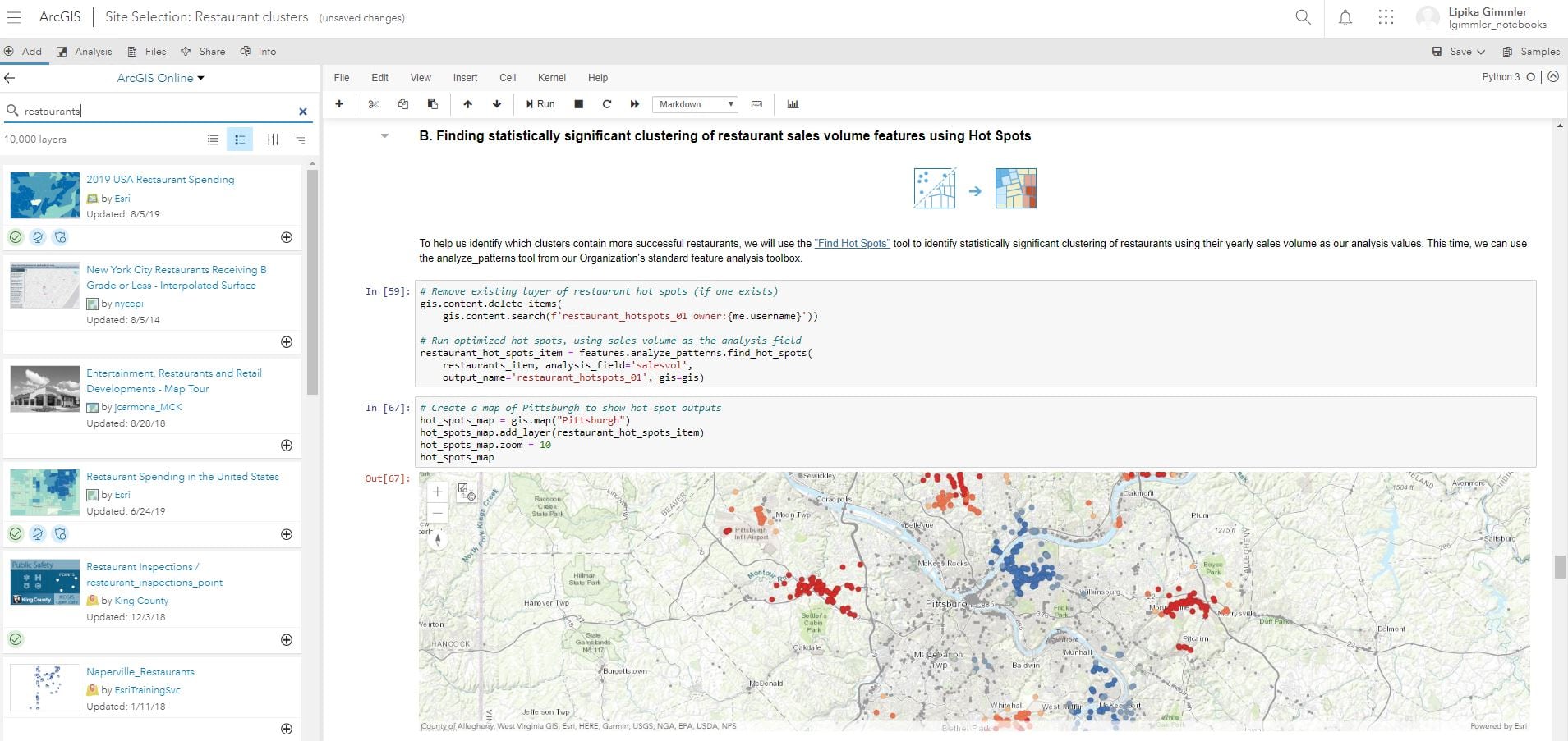
Spatial Statistics and Machine Learning
Spatial statistics and spatial machine learning empowers you to answer questions confidently and make important decisions analytically.
- On-Demand: Machine Learning in ArcGIS: An Introduction
- On-Demand: Machine Learning Explained: Finding Clusters
- On-Demand: Geostatistical Analyst: An Introduction
- On-Demand: Geostatistical Analyst: Kriging
- Bring your questions to the teams! Search for Spatial Statistics and Geostatistical Analyst in the showcase.
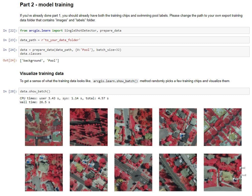
Imagery and Raster Analysis
Use advanced spatial modeling and the latest advancements in AI to discover spatial patterns in imagery and raster data.
- On-Demand: Spatial Analyst: An Introduction
- Streaming Live: Distance Analysis: Identifying Optimal Paths Using Rasters
- On-Demand: Finding the Best Locations Using Suitability Modeling
- On-Demand: Interpolating Surfaces in ArcGIS
- On-Demand: Hydrological Analysis Tools in ArcGIS
- On-Demand: Working with Multidimensional Data in ArcGIS
- Streaming Live: Using Deep Learning with Imagery in ArcGIS
- On-Demand: Deep Learning for Geographers
- On-Demand: Deep Dive into Deep Learning
- Bring your questions to the teams! Search for Spatial Analyst, Multidimensional Analysis and Deep Learning in the showcase.
3D Analysis
Get more out of your 3D data through modeling and analysis.
- Streaming Live: Lidar Classification and Feature Extraction
- On-Demand: 3D Feature and Sub‐Surface Analysis
- On-Demand: 3D Analyst: Surface Modeling with 3D Analyst
- On-Demand: Lidar in ArcGIS: An Introduction
- Bring your questions to the teams! Search for 3D Analyst in the showcase.
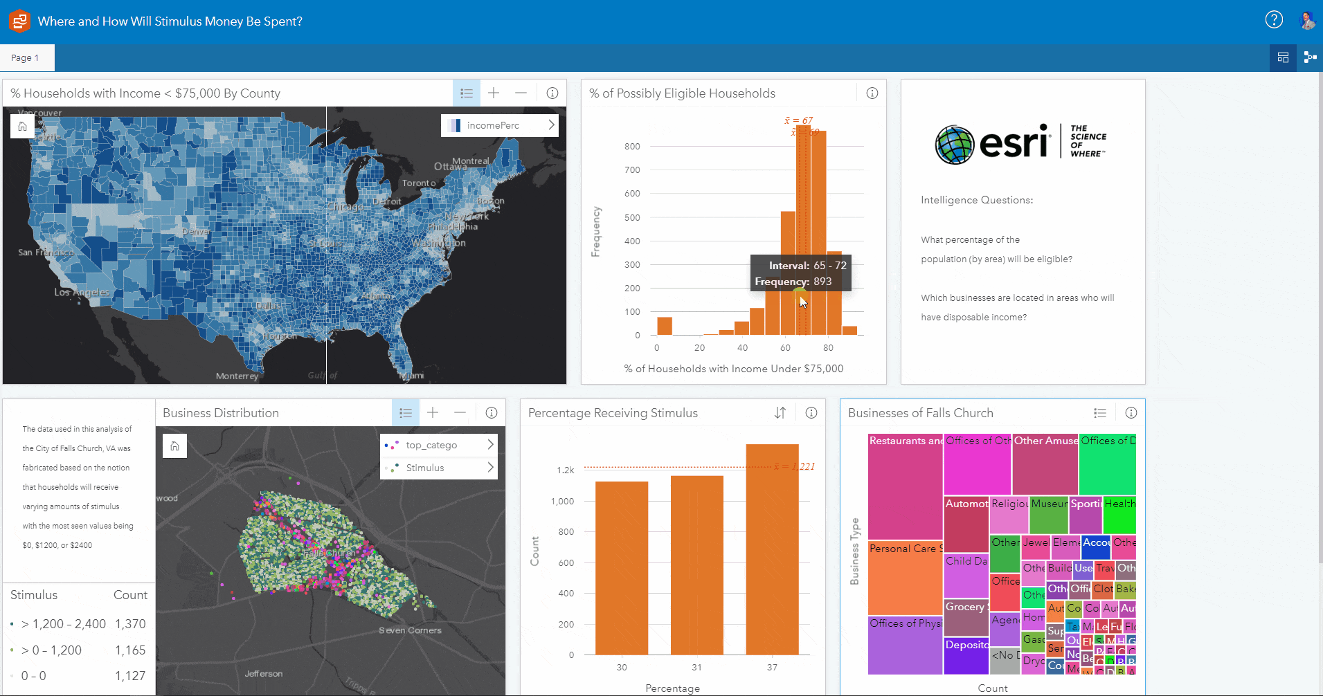
ArcGIS Insights
Analysis software that fuses location analytics with open data science and business intelligence workflows.
- Streaming Live: ArcGIS Insights: Data Visualization, Analysis and Science
- On-Demand: ArcGIS Insights: Best Practices
- On-Demand: ArcGIS Insights: An Introduction to Data Analytics and Visualization
- On-Demand: ArcGIS Business Analyst: An Introduction
- Bring your questions to the teams! Search for ArcGIS Insights in the showcase.
ArcGIS Business Analyst
Location-based intelligence for planning, site selection, and customer segmentation
- Streaming Live: ArcGIS Business Analyst: What’s New and Coming Soon
- On-Demand: Using Your Own Data with Enrichment and Infographics
- Bring your questions to the teams! Search for ArcGIS Business Analyst in the showcase.
Other sessions can be found in the full agenda for the conference. Be sure to register in advance!


Article Discussion: