What happens when a troupe of geodetic datums gather under a single coordinate reference system (CRS)? They form a datum ensemble and perform a harmonious datum dance!

While datum ensembles make it easier to integrate data from different sources, they also introduce tradeoffs, including reduced positional accuracy and the potential for misalignment when working with high precision data. This blog explains what datum ensembles are, when and why they were introduced, and how they affect daily GIS workflows. Using the World Geodetic System of 1984 (WGS 84) datum ensemble as an example, it highlights the practical implications and general nature of datum ensembles that many GIS users may not be aware of.
What is a datum ensemble?
A datum ensemble is a group of closely related realizations of the same terrestrial reference system (TRS) or vertical reference system (VRS). To understand this more clearly, let’s parse out the terminology.
A geodetic terrestrial reference system (TRS) is a 3D coordinate system centered at the Earth’s center of mass. It rotates with the Earth and uses standard meters for measuring distance. Its three Cartesian axes (X, Y, and Z) stay fixed in a stable orientation, even though the Earth’s tectonic plates move. In short, a TRS provides an Earth‑centered, Earth‑fixed coordinate system used for mapping, navigation, and positioning.
A terrestrial reference system is just an abstract idea – it doesn’t give us actual points on the Earth that we can measure or use directly. To make it usable, we need to connect the TRS to the real Earth. This is done by measuring and defining a set of physical reference points on Earth’s surface that follow the rules of the TRS. Today, this is done using various geodetic observing methods, one of which is with a global set of permanent GNSS tracking stations.
When we create this real-world version of the TRS, it becomes a terrestrial reference frame (TRF), also known as a geodetic datum. The TRF is what anchors the abstract system to the Earth so that geospatial professionals, including GIS users, can accurately measure positions.
A widely used TRS/TRF is WGS 84. WGS 84 is a reference system that becomes tied to the real Earth by using the measured coordinates of 17 Global Positioning System (GPS) tracking stations around the world. When WGS 84 is anchored this way, it becomes a realization, known as the WGS 84 terrestrial reference frame (TRF).
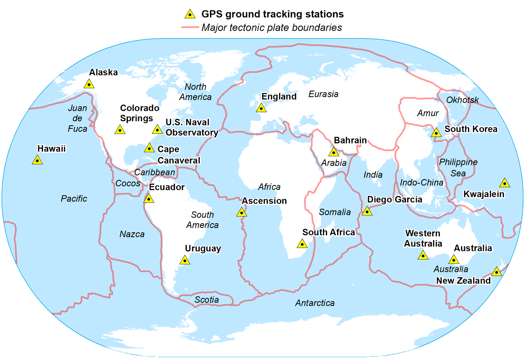
As technology improves with better instruments, better processing methods, and more tracking stations, we can create more accurate realizations (or versions) of a reference system. For WGS 84, there have been eight different realizations so far. Each realization is tagged with a “G‑number,” which refers to the GPS week during which satellite observations were collected to define that version (e.g. the current realization of WGS 84 is WGS 84 (G2296)).
Even though the WGS 84 TRS (the abstract definition) stays the same, each new realization becomes a slightly updated WGS 84 TRF, with small differences in coordinates. The underlying reason for this is that WGS 84 is a dynamic datum, meaning that coordinates change slightly over time – something we can dive into in another blog post!
Because all eight slightly different realizations of WGS 84 are closely related and based on the same TRS, they together represent the WGS 84 datum ensemble. As new data and better technology become available, we can expect more updated WGS 84 realizations in the future.
Why do we need ensembles?
The widespread adoption of WGS 84 Web Mercator basemaps allow users to easily overlay their own GIS data on top of online mapping layers. However, this convenience came with an important requirement: any dataset not originally referenced to WGS 84 needed to be transformed into WGS 84 to align with the basemap.
As more datasets were combined – or “mashed up” – on these WGS 84 Web Mercator basemaps, small positional misalignments began to appear. These discrepancies were typically subtle, but noticeable when overlaying multiple layers. Three primary issues contributed to this problem:
- Most datasets did not specify which realization of WGS 84 they used.
- Transformations to specific WGS 84 realizations were often unavailable.
- Transformations between different WGS 84 realizations were also unavailable.
Without this information GIS software had no reliable way to correctly align datasets tied to slightly different versions of WGS 84, even though the differences between those versions might only be a few centimeters.
The long-term solution to this challenge was the introduction of the datum ensemble. A datum ensemble allows multiple closely related realizations of a reference system, such as WGS 84, to be treated as a single group for most GIS applications.
In practice, new realizations of terrestrial or vertical reference systems often differ only by a small amount, typically on the order of centimeters. For many GIS use cases, especially those involving lower-accuracy data, these differences are negligible.
Datum ensembles simplify workflows by allowing users to group these nearly equivalent realizations together. As a result, datasets based on any of the included member realizations can be combined without explicitly transforming coordinates between them, because they are treated as effectively the same.
In summary, datum ensembles provide a practical way to manage consistency across datasets when high precision is not required. However, for high-accuracy applications, such as surveying, geodesy, or engineering, users should still work with the specific reference frame realization under which the data was collected and apply precise transformations where necessary.
Where did the datum ensemble come from?
The datum ensemble was introduced in the ISO 19111:2019 standard and adopted by the OGC. In these standards, datum ensemble is defined as
“…a collection of two or more reference frames that are realizations of one Terrestrial or Vertical Reference System and which for all but the highest accuracy requirements may be considered to be insignificantly different from each other.”
Therefore, GIS data that uses slightly different versions of the same reference system can all be assigned to one common, representative datum – the ensemble. This makes it much easier to combine and manage data without having to transform coordinates between very similar frames.
In short: datum ensembles let users treat very similar geodetic datums as the same one, provided high‑precision accuracy isn’t required.
On February 13, 2020, the EPSG Geodetic Parameter Dataset (Version 10.0) officially added the new concept of a datum ensemble following the ISO 19111:2019 and ISO 19162:2019 (WKT2) standards. At the same time, EPSG redefined WGS 84 as a datum ensemble rather than a single datum. This ensemble is identified as EPSG::6326.
This made the WGS 84 ensemble the very first datum ensemble in the EPSG geodetic registry. From that point on, Web Mercator became referenced to the WGS 84 datum ensemble instead of an individual WGS 84 realization.
How are datum ensembles constructed?
When building a Coordinate Reference System (CRS) – or a Geographic Coordinate System (GCS) in Esri terms – you normally assign it a single geodetic datum. However, modern standards allow a datum ensemble to be used in place of an individual datum.
A datum ensemble is treated just like a datum inside a CRS, but instead of representing one specific realization, it represents a group of closely related datums. All datums in the ensemble share the same ellipsoid and prime meridian, meaning they are almost identical at the basic geometric level.
Standards such as ISO 19111:2019 and OGC Topic 2 describe datum ensembles conceptually, and formats like ISO 19162:2019 (WKT2) show how real examples, such as the WGS 84 datum ensemble, are defined.
It is important to note that members of a datum ensemble do not need to share the same area of use, and their individual extents may also differ from that of the ensemble as a whole. For example, in the WGS 84 ensemble (EPSG::6326), each member applies globally, so their areas of use are identical to one another and to the ensemble itself. In contrast, the British Isles height ensemble (EPSG::1288) presented in the next section includes members with distinct, localized areas of use that fall within the overall spatial extent of the ensemble.
Datum ensemble examples
Standards such as ISO 19162:2019 and OGC WKT2 2.1.11 include real-world examples of how datum ensembles are written in Well‑Known Text (WKT) format. In WKT2, a CRS that uses the WGS 84 datum ensemble includes an ENSEMBLE element instead of a single DATUM. This element identifies:
- the name of the datum ensemble (e.g., “World Geodetic System 1984 ensemble”),
- the members of the ensemble (the different WGS 84 realizations, such as WGS 84 (G2296)), and
- the accuracy associated with the ensemble.
So instead of pointing to one exact WGS 84 realization, the CRS points to the entire group, because they are similar enough for most GIS uses.
The WGS 84 ensemble, when used within a CRS, in WKT2 format is shown below:
GEOGCRS["WGS 84",
  ENSEMBLE["World Geodetic System 1984 ensemble",
    MEMBER["World Geodetic System 1984 (Transit)"],
    MEMBER["World Geodetic System 1984 (G730)"],
    MEMBER["World Geodetic System 1984 (G873)"],
    MEMBER["World Geodetic System 1984 (G1150)"],
    MEMBER["World Geodetic System 1984 (G1674)"],
    MEMBER["World Geodetic System 1984 (G1762)"],
    MEMBER["World Geodetic System 1984 (G2139)"],
    MEMBER["World Geodetic System 1984 (G2296)"],
    ELLIPSOID["WGS 84",6378137,298.257223563,
      LENGTHUNIT["metre",1]],
    ENSEMBLEACCURACY[2.0]],
  PRIMEM["Greenwich",0,
    ANGLEUNIT["degree",0.0174532925199433]],
  CS[ellipsoidal,2],
    AXIS["geodetic latitude (Lat)",north,
      ORDER[1],
      ANGLEUNIT["degree",0.0174532925199433]],
    AXIS["geodetic longitude (Lon)",east,
      ORDER[2],
      ANGLEUNIT["degree",0.0174532925199433]],
  USAGE[
    SCOPE["Horizontal component of 3D system."],
    AREA["World."],
    BBOX[-90,-180,90,180]],
  ID["EPSG",4326]]
What many GIS users casually call “WGS 84” isn’t just one fixed datum. Instead, it is an ensemble of eight different realizations of the WGS 84 Terrestrial Reference System. The first version, called Transit, was created in 1984 using early satellite technologies. Over time, WGS 84 has been updated several times to improve accuracy.
Since 1994, each new realization of WGS 84 has been aligned to different ITRF realizations, usually within 10 cm or less, and each new WGS 84 version is generally within a few centimeters of the previous one.
Even with these differences, the WGS 84 ensemble continues to be the most widely used global reference frame. This is mainly because it is easy to access and is deeply built into most GPS devices, GIS software, and geospatial workflows.
For completeness, an example of a vertical reference system (VRS) datum ensemble is the British Isles height ensemble:
VERTCRS["BI height",
  ENSEMBLE["British Isles height ensemble",
    MEMBER["Malin Head"],
    MEMBER["Belfast Lough"],
    MEMBER["Ordnance Datum Newlyn"],
    MEMBER["Ordnance Datum Newlyn (Offshore)"],
    MEMBER["Ordnance Datum Newlyn (Orkney Isles)"],
    MEMBER["Lerwick"],
    MEMBER["Stornoway"],
    MEMBER["Douglas"],
    MEMBER["St. Marys"],
    ENSEMBLEACCURACY[0.4]],
  CS[vertical,1],
    AXIS["gravity-related height (H)",up,
      LENGTHUNIT["metre",1]],
  USAGE[
    SCOPE["Spatial referencing."],
    AREA["United Kingdom (UK) - offshore to boundary of UKCS within 49°45'N to 61°N and 9°W to 2°E; onshore Great Britain (England, Wales and Scotland) and Northern Ireland. Ireland onshore. Isle of Man onshore."],
    BBOX[49.75,-10.85,61.01,2.01]],
  ID["EPSG",9451]]
The table below lists geographic and vertical datum ensembles currently available in ArcGIS Pro 3.7 software.
| Datum Ensemble Name | WKID | |
|---|---|---|
| Geographic | World Geodetic System 1984 ensemble | EPSG::6326 |
| European Terrestrial Reference System 1989 ensemble | EPSG::6258 | |
| Greenland Reference 1996 ensemble | EPSG::1421 | |
| Vertical | British Isles height ensemble | EPSG::1288 |
| Denmark Lowest Astronomical Tide ensemble | EPSG::1377 | |
| Denmark Mean Sea Level ensemble | EPSG::1376 | |
| Dansk Vertikal Reference 1990 (DVR90) ensemble | EPSG::1371 | |
No doubt, many more ensembles will become available going forward. Keep an eye out for them!
Caveat emptor – let the ensemble user beware
Using a datum ensemble comes with important warnings:
- Data referenced to a CRS with a datum ensemble is deemed accurate to the ensemble’s stated accuracy level. For WGS 84 ensemble, this accuracy is 2 meters.
- If your data uses a CRS tied to an ensemble, you cannot tell which specific member datum it originated from. This means high‑accuracy data is assigned lower accuracy if it is labeled with an ensemble instead of its exact datum.
- If you mix high‑accuracy data using a specific datum with data tied to a datum ensemble, small misalignments may appear. For low‑accuracy GIS applications, using a datum ensemble is fine and often convenient.
- For surveying, engineering, or any high‑precision work, do not use a datum ensemble. Instead, assign your GIS data to the specific terrestrial reference frame (TRF) it was collected in.
Web Mercator projected CRS and the WGS 84 ensemble
WGS 84 Web Mercator is a very common projected CRS used by many commercial and open‑source datasets, as well as most web‑mapping applications. It is important to understand that Web Mercator is based on the WGS 84 datum ensemble. As a result, when working with Web Mercator maps, data is typically transformed on the fly into the WGS 84 ensemble so that everything aligns visually. The ensemble has an accuracy of about 2 meters, which means that datasets referenced to different WGS 84 ensemble members may differ by that amount.
In addition to being based on the WGS 84 datum ensemble, Web Mercator introduces increasing projection distortion for areas and distances measured away from the Equator. Because of this, positional differences between data referenced to Web Mercator and the WGS 84 ensemble may exceed the ensemble’s stated accuracy of 2 meters. This can lead to visible misalignment between:
- different GIS datasets, and/or
- your datasets and the Web Mercator basemap
The issue becomes more noticeable when high‑accuracy data is mixed with lower‑accuracy data for areas further away from the Equator, because everything gets “flattened” into the WGS 84 ensemble and displayed in Web Mercator with large projection distortion. When this happens, the high‑accuracy data effectively loses precision.
That’s why the general rule is: Only use a datum ensemble when you are not concerned about small positional differences between the ensemble’s member datums.
For work that requires high positional accuracy, you should always use a specific datum realization (such as a particular WGS 84 or ITRF version), not a datum ensemble. Datum ensembles are designed for general‑purpose mapping where small differences of a few centimeters, or even a couple of meters, don’t matter.
Additional resources
ISO 19111:2019 Geographic information — Referencing by coordinates
ISO 19162:2019 Geographic information — Well-known text representation of coordinate reference systems
OGC Abstract Specification Topic 2: Referencing by coordinates
EPSG Geodetic Parameter Dataset
WGS 1984 is not what you think!
Transforming between WGS84 realizations





Commenting is not enabled for this article.