Most spatial analysis projects begin long before the analysis itself.
Before you can find similar places such as affordable neighborhoods or build a predictive model for tasks such as estimating house prices, or even explore spatial patterns across communities, you first need location context. That often means gathering a plethora of geospatial datasets spanning across demographics, socioeconomics, and a multitude of other domains, and then figuring out how to bring them together into a usable contextual dataset for your applications.
For many workflows, preparing the data can take as much effort as the analysis. But what if that location context was already available?
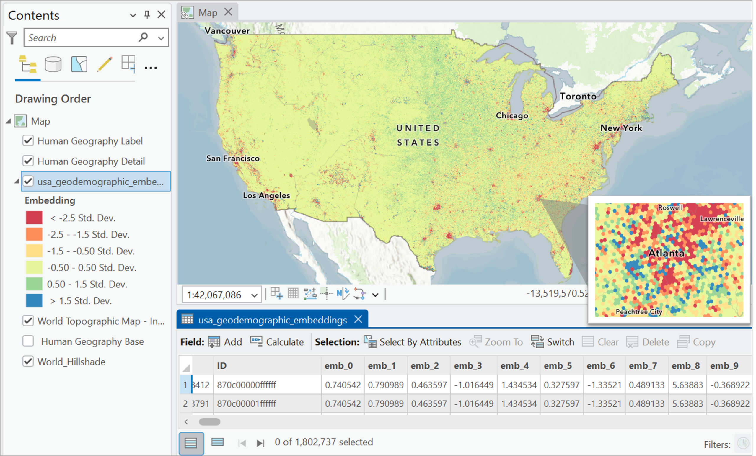
In this year’s Esri User Conference (July 2026), we introduce USA Geodemographic Embeddings, a new layer in ArcGIS Living Atlas of the World that captures demographic, housing, socioeconomic, and environmental characteristics for locations across the contiguous United States, Hawaii, and Alaska at the Uber H3 resolution 7 hex-bin geometry.
Designed for spatial analysis, machine learning, and GeoAI workflows, the embeddings provide a ready-to-use and reusable representation of geodemographic context that can be applied across a wide range of tasks directly in ArcGIS Pro.
Start with a place
Imagine you’re exploring an affordable place in your neighborhood and want to find similar places elsewhere in the country.
What are the steps that you’d follow to do this?
You’d probably select dozens of variables for describing affordable localities such as median family income, monthly housing costs, and so on. Then decide how much each variable should matter, followed by standardizing all the values. Finally, you’d end up building a custom similarity model.
With USA Geodemographic Embeddings, you can start with just the place. Yes, that’s all you need.
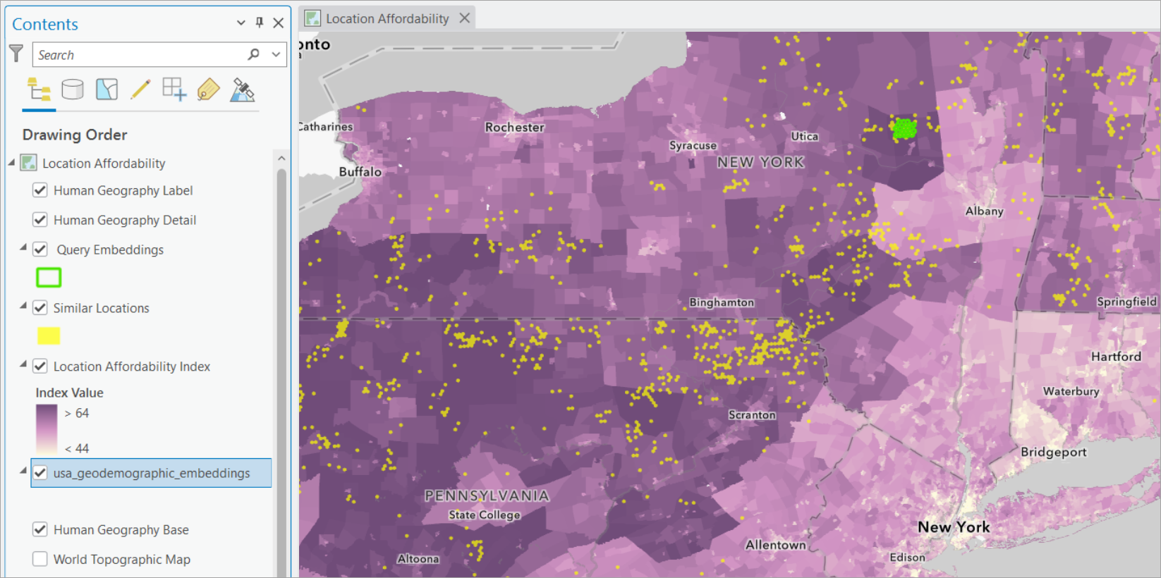
In an example workflow, a few embedding hex-bins covering some affordable locations near Utica, New York, (shown with green polygons) are used as query features for finding similar locations.
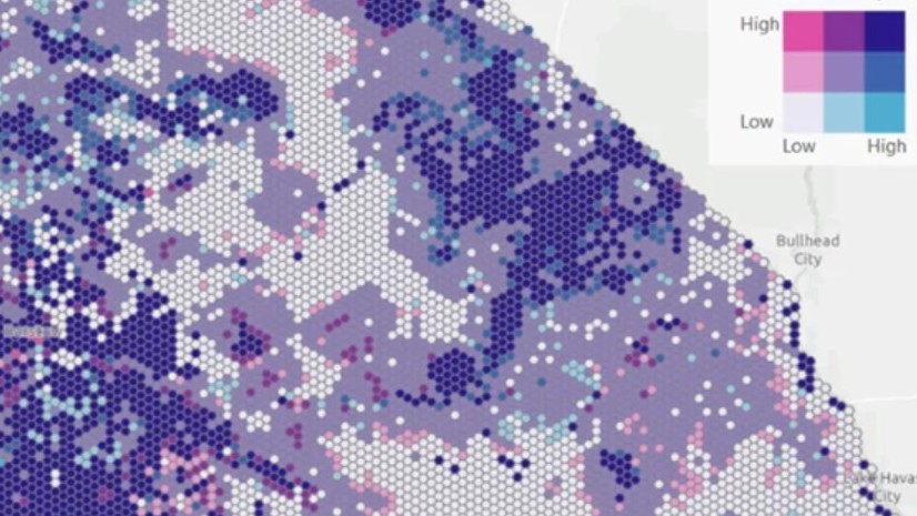
Using embedding-based similarity search with the Find Similar Features Using Embeddings tool, ArcGIS Pro identifies affordable areas in other states (shown with yellow polygons) that share similar underlying geodemographic characteristics. You can also take a look at the actual Location Affordability Index map, in shades of purple for comparison (darker shades indicate more affordability).
The result isn’t just geographic proximity—it’s contextual similarity.
Whether you’re evaluating retail markets, studying neighborhoods, or exploring comparable communities, the same workflow with USA Geodemographic Embeddings can help answer your question—where are places like this one?
Add context to your models
Predictive models heavily depend on the explanatory variables we choose to include.
A housing price model, for example, might use variables such as the number of rooms, median income, and so on. These factors explain part of the story—but not always all of it.
Location matters too.
The neighborhood surrounding a property, the demographic profile of nearby communities, housing patterns, and environmental conditions can all influence the housing prices in ways that are difficult to capture individually.
Because the embeddings in USA Geodemographic Embeddings are a distillation of many aspects of geodemographic context into a simple vector of numbers, they can be used alongside existing predictors to enrich downstream models. In the housing price example shown below, adding embeddings to the original predictor set improved model performance compared to using the original variables alone.
The goal isn’t to replace existing variables; it’s to complement them with additional geographic context.
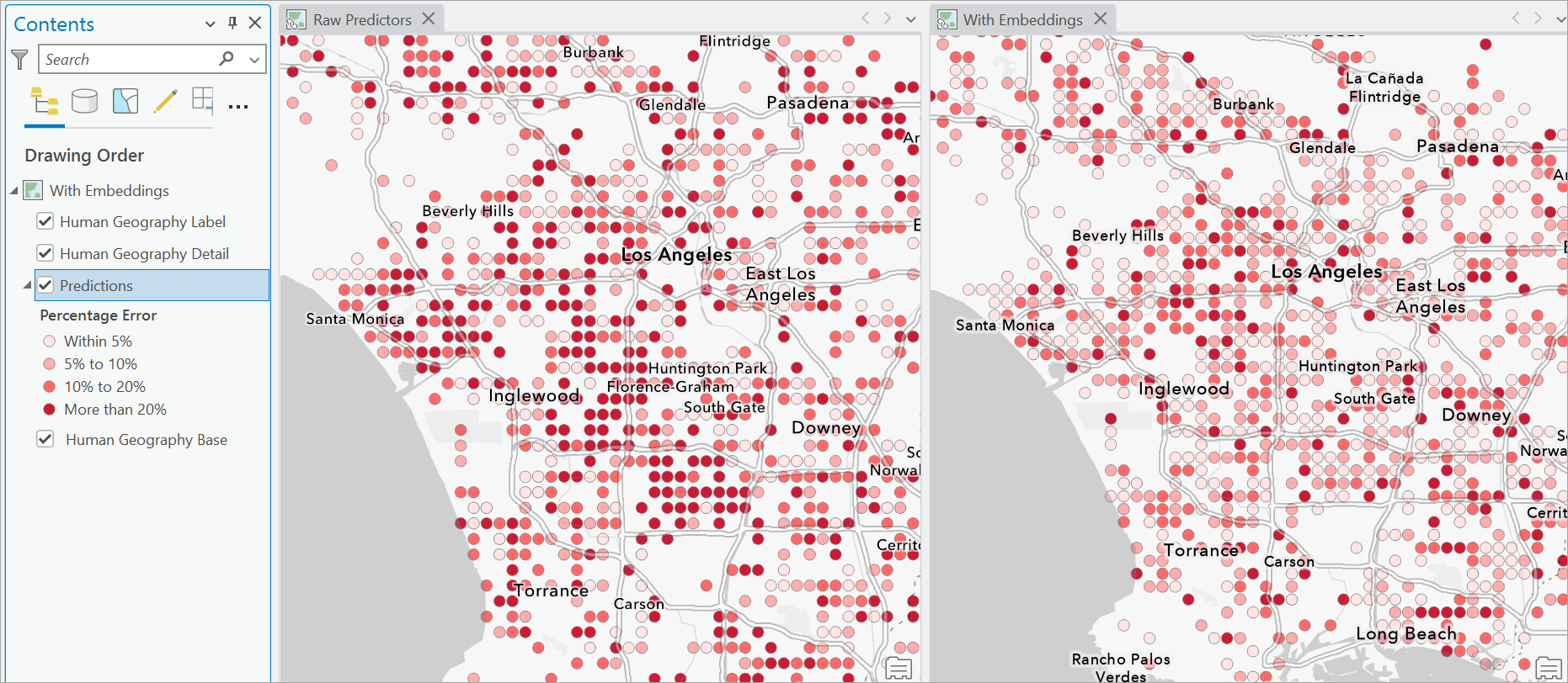
You might often find use-cases in which there aren’t any existing explanatory variables for the target you want to predict. The embeddings in USA Geodemographic Embeddings can be plugged in as the contextual predictors even then.
Explore patterns across places
Not every project begins with a similarity search workflow or a prediction. Sometimes the goal is simply to understand how places relate to one another.
Which communities share similar characteristics? Where do transitions occur across a region? Are there groups of locations that behave similarly despite being far apart geographically?
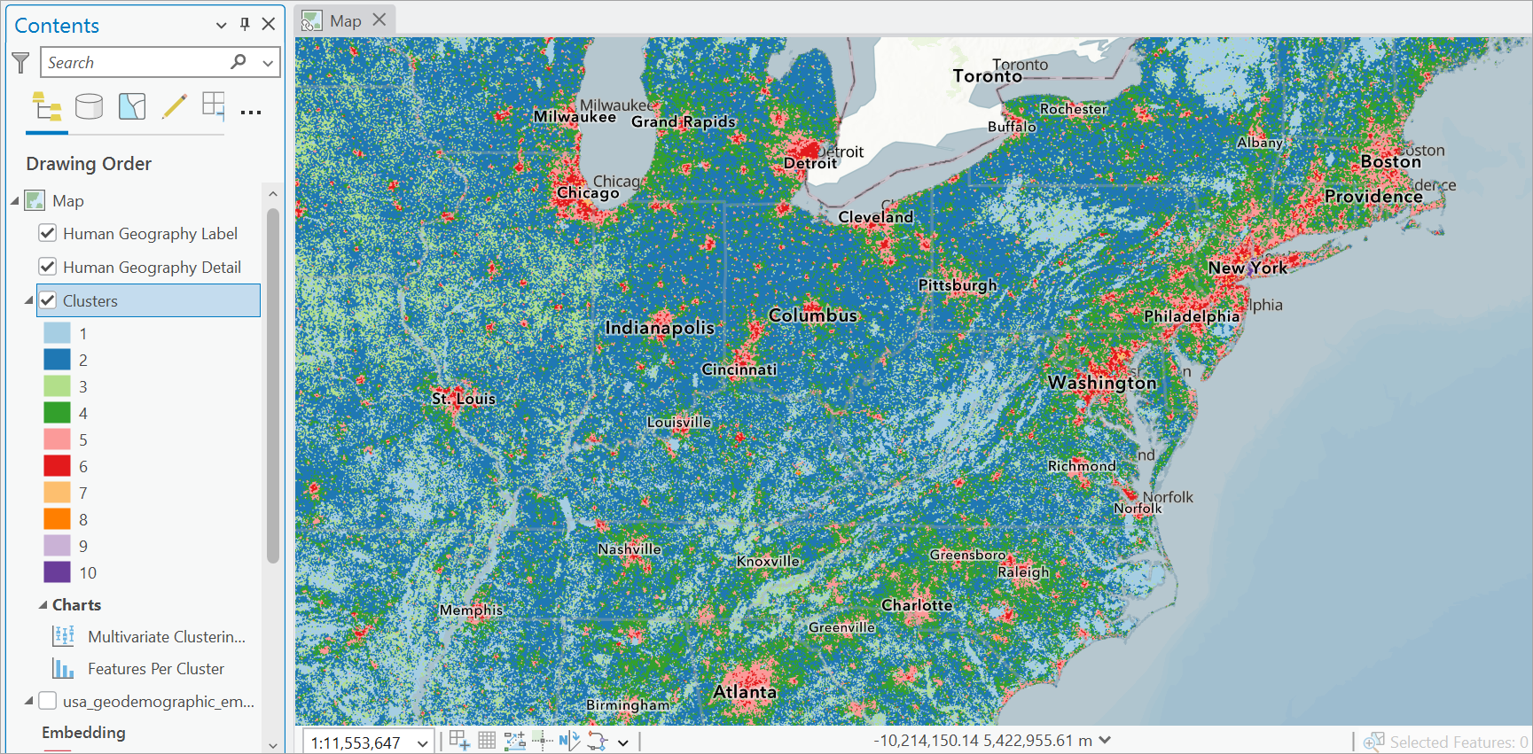
The embeddings in USA Geodemographic Embeddings can be used to answer these questions directly. Use them for finding clusters to help reveal patterns that may not be apparent when examining individual datasets separately.
A reusable layer for geographic context
By now, you must have learned one of the most interesting aspects of the embeddings in USA Geodemographic Embeddings—that they are not tied to a single application.
The same layer can support similarity search, clustering, model enrichment, and other GeoAI workflows. That too, without assembling a new collection of geodemographic and environmental variables for every new project.
Behind the scenes, the embeddings are generated using Esri’s Geodemographic Foundation Model (GDFM). For most users, however, the important detail isn’t how the embeddings are created.
It’s what they enable.
They provide a new way to add context into analysis—a way that is reusable, scalable, and ready to support the next generation of spatial analysis and GeoAI workflows.
Make the most out of the embeddings
Like any contextual dataset, USA Geodemographic Embeddings works best when used thoughtfully.
A good starting point is to treat the embeddings as one single feature rather than a collection of individual variables. The information is distributed across all embedding dimensions, so they are most effective when used together.
The embeddings are expected to perform best in workflows in which geodemographic context matters.
For predictive workflows, embeddings don’t have to replace existing explanatory variables. As you have seen above, they can be used alongside domain-specific data to provide additional context and help enhance downstream analysis.
If you’re exploring the embeddings for the first time, consider starting with a similarity search or clustering workflow. These approaches provide an intuitive way to understand how locations relate to one another before moving on to more advanced modeling tasks.
Get started
The USA Geodemographic Embeddings layer is available through ArcGIS Living Atlas of the World and can be accessed directly in ArcGIS Pro. The layer works with embedding-aware tools including Find Similar Features Using Embeddings, Merge Embeddings, and Extract Embeddings, model development workflows such as Train Using AutoML, and many other ArcGIS Pro tools, making it easy to incorporate them into existing projects.
We look forward to seeing how you use them for your workflows.


Article Discussion: