Military Tools for ArcGIS functionality is included with the standard ArcGIS Pro 2.6 installation.
ArcGIS Pro 2.6 includes all the functionality previously included in Military Tools for ArcGIS. If you are new to the suite of defense-based tools or want a refresher, primary functional areas include the following:
- Coordinate Conversion
- Distance and Direction
- Military Symbology Editor
- Visibility Analysis
Coordinate Conversion
Using Coordinate Conversion, you can input coordinates using one coordinate system and output them to different coordinate systems in multiple notation formats. The Coordinate Conversion tools are found in the Inquiry group on the Map tab.

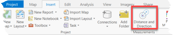
Distance and Direction
Using Distance and Direction, you can draw geodetic lines, circles, ellipses, and rings to visualize relevant information. Lines, circles, ellipses, and rings are created as features stored in a feature dataset in the project geodatabase and are added to the table of contents. You can export lines, circles, ellipses, and rings to a new feature class, shapefile, or .kmz file for further analysis and planning or use in other systems. The Distance and Direction tools are found in the Measurements group on the Insert tab.
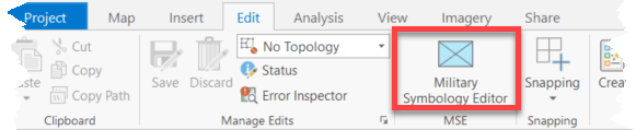
Military Symbology Editor
Using Military Symbology Editor you can search for basic symbols, modify attributes, preview complete military symbols, and save favorites. You can add these military symbols to the map by clicking the map or entering coordinates. The Military Symbology Editor tools can be added to a new or existing tab by customizing the ribbon.
Visibility Analysis
Using Visibility Analysis tools along with elevation data and observer information, you can produce linear line of sight (LLOS) and radial line of sight (RLOS) information. The Visibility Analysis tools can be found in the Workflows group on the Analysis tab.

What this means for the user
- When using ArcGIS Pro 2.6, there is no need to download or install additional items to get this functionality.
- All Military Tools for ArcGIS functionality is included in ArcGIS Pro 2.6.
- Esri will continue to support Military Tools for ArcGIS in ArcGIS Pro 2.2–2.5 as long as those product versions are supported.
- Only updates for critical bug fixes will be applied to Military Tools for ArcGIS in ArcGIS Pro 2.2–2.5.


Article Discussion: