
The 2026 Esri User Conference (July 13–17) in San Diego is just weeks away! It’s been a year of significant advancements for real-time GIS, and we can’t wait to share what’s new. Real-time GIS enables organizations to ingest, visualize, and analyze streaming data as it happens — powering operational digital twins, shortening the time from observation to decision. Join us to explore what’s new with ArcGIS Velocity and ArcGIS GeoEvent Server, the products that power these real-time capabilities across ArcGIS.

Join Us at the Showcase
| Day and Date | Time | Location |
| Tuesday, July 14 | 9:00 a.m.–5:30 p.m. | Halls A/B/C/D |
| Wednesday, July 15 | 9:00 a.m.–5:30 p.m. | Halls A/B/C/D |
| Thursday, July 16 | 9:00 a.m.–4:00 p.m. | Halls A/B/C/D |
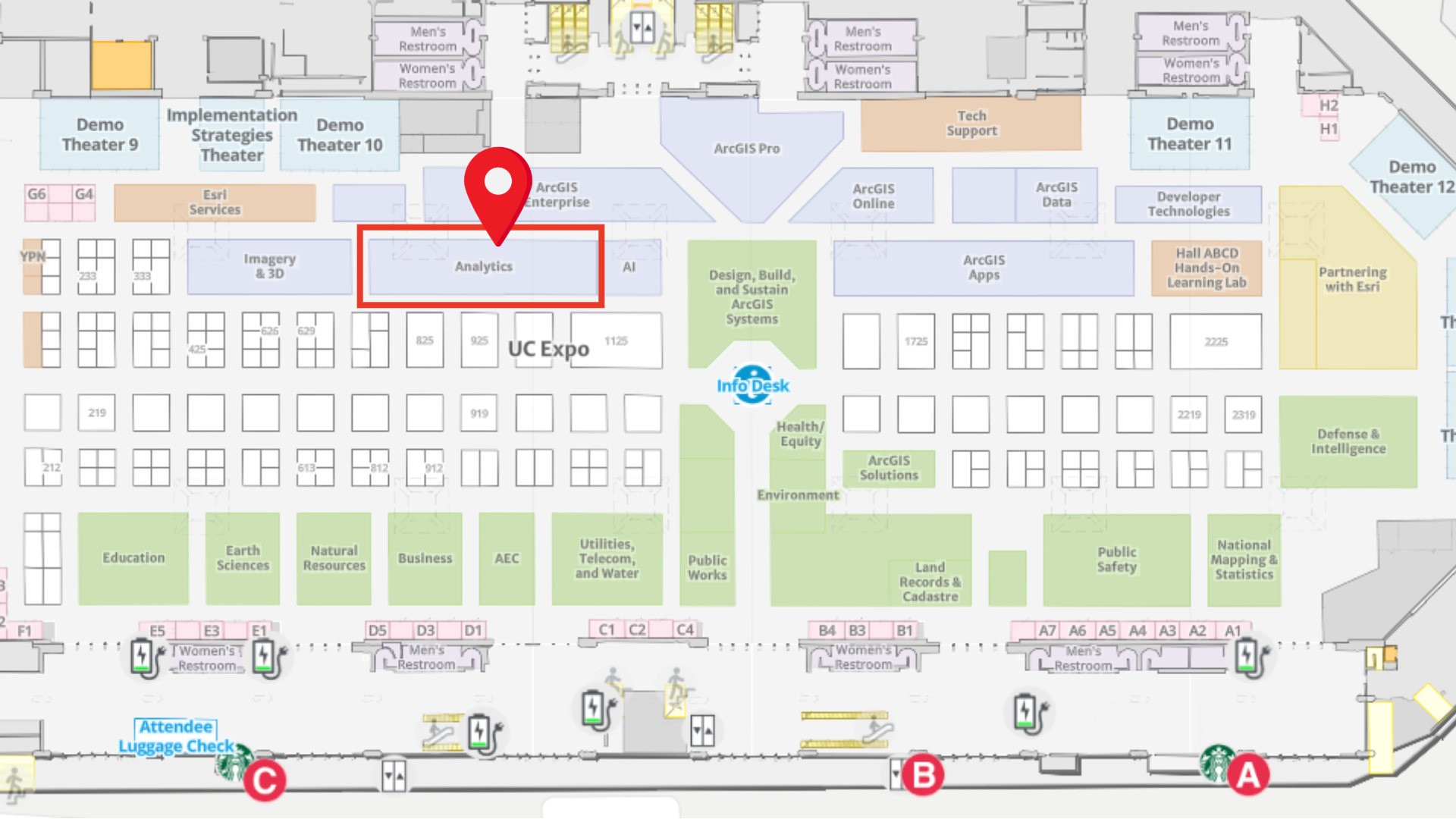
Explore the 2026 Esri UC Events Map via web and mobile (iOS or Android) to locate us in the showcase and navigate to the booth and sessions. You can also consult on-site interactive kiosks in the expo area to get directions at the event venue.
Whether you are interested in seeing the latest updates in ArcGIS Velocity and ArcGIS GeoEvent Server or looking for answers, our experts are available to help! We are located in the Analytics area within the Esri showcase. Stop by for a chat or to see a product demonstration.
Must-Attend Real-Time Sessions
We have curated a list of product-focused sessions to deepen your understanding of real-time GIS.
ArcGIS Velocity: An Overview
ArcGIS Velocity is a real-time analysis capability in both ArcGIS Online and ArcGIS Enterprise, enabling organizations to ingest, analyze, and act on data from Internet of Things (IoT) sensors. Join the discussion on how to connect to virtually any type of streaming data, perform real-time analytics and processing, and automatically disseminate information and alert personnel when specified conditions occur.
Presenters: Jeff Eisman and Ricardo Trujillo
Session Type: Technical Session
Offering 1: Tuesday, July 14, 1:00 PM–2:00 PM PT
Room 4 | SDCC
Offering 2: Wednesday, July 15, 8:30 AM–9:30 AM PT
Room 32 B | SDCC
ArcGIS GeoEvent Server: Migrating Workflows to ArcGIS Velocity
ArcGIS GeoEvent Server has powered real-time event processing in ArcGIS Enterprise. Now, ArcGIS Velocity is available for ArcGIS Enterprise, so organizations can modernize and scale their real-time analytics workflows using advanced real-time architecture. This presentation provides practical guidance for transitioning GeoEvent Server workflows to Velocity, including best practices for connecting to real-time feeds, designing equivalent or enhanced analytic logic, managing performance, and integrating with the broader ArcGIS system.
Presenters: Nicole Phaneuf and Sam Juarez
Session Type: Technical Session
Tuesday, July 14, 2:30 PM–3:30 PM PT
Room 1 B | SDCC
ArcGIS Velocity: Applying Real-Time Analytics
Explore the analytic power of ArcGIS Velocity. This presentation demonstrates how to detect incidents in real time, enrich sensor data, automate processing using scheduled big data analytics, and uncover patterns and anomalies in high-volume historical datasets.
Presenters: Yini Song and Joanna Nishimura
Session Type: Demo Theater Presentation
Wednesday, July 15, 10:00 AM–10:45 AM PT
Demo Theater 6 | SDCC
Real-Time GIS: The Road Ahead
Discover the future of real-time GIS at Esri. With ArcGIS Velocity available for ArcGIS Enterprise on Windows and Linux, organizations can now deploy real-time analyses in self-hosted environments. This presentation highlights new capabilities, deployment options, and the product road map. Speakers also discuss the future of ArcGIS GeoEvent Server and how to plan the transition to ArcGIS Velocity.
Presenters: Hayley Miller and Josh Joyner
Session Type: Technical Session
Wednesday, July 15, 2:30 PM–3:30 PM PT
Room 24 B | SDCC
Additional Sessions Where You Will Find Real-Time Content
In addition to product-focused sessions, real-time GIS will be featured across many sessions at UC.
Reimagining Right‑of‑Way Management with Real-Time Workflows
This session highlights how organizations are modernizing land and asset management using real-time GIS and advanced data models. It shows how automated change detection and modern parcel management tools improve coordination, accuracy, and decision-making.
Session Type: User Presentation
Tuesday, July 14, 10:00 AM–11:00 AM PT
Pacific Ballroom Salon 26 | Marriott
Public Works as a Platform for Innovation
This presentation demonstrates how public works departments are transitioning to enterprise platforms that provide real-time awareness and advanced analytics. It highlights how technologies like digital twins, AI, and drones are enabling innovation.
Presenters: Adam Carnow
Session Type: Demo Theater Presentation
Tuesday, July 14, 4:00 PM–4:45 PM PT
Demo Theater 5 | SDCC
ArcGIS: A System for National Security
This session explores how ArcGIS enhances intelligence workflows by integrating diverse data sources into a unified operational picture. It highlights real-time ingestion and advanced analytics to support mission execution.
Presenters: John Fry and Katharine Weintraub
Session Type: Technical Session
Wednesday, July 15, 10:00 AM–11:00 AM PT
Room 5 A | SDCC
ArcGIS: Data-Driven Operations for Public Safety
This session shows how organizations integrate real-time and static data to support public safety operations and improve decision-making.
Presenters: Colin Cate and Brooks Shannon
Session Type: Demo Theater Presentation
Wednesday, July 15, 11:30 AM–12:15 PM PT
OPS Center Demo Theater | SDCC
Improving Transit On-Time Performance
This session provides an overview of the Transit On-Time Performance solution and shows how to track performance metrics in real time and analyze trends.
Presenters: Mike Dagle
Session Type: Insight Talk
Wednesday, July 15, 1:40 PM–2:00 PM PT
State and Local Government Expo Theater | SDCC
ArcGIS: Maritime Security
This session demonstrates how ArcGIS integrates static and real-time data to support maritime and border security operations. It highlights best practices for combining data into actionable insights.
Presenters: Colin Cate and Carl Walter
Session Type: Demo Theater Presentation
Thursday, July 16, 1:00 PM–1:45 PM PT
OPS Center Demo Theater | SDCC
ArcGIS Velocity: Public Safety Workflows
This session demonstrates how real-time workflows can be implemented within your infrastructure using ArcGIS Velocity. It highlights use cases such as watch centers and feed aggregation.
Presenters: Anthony Schultz and Kevin Armstrong
Session Type: Demo Theater Presentation
Thursday, July 16, 2:30 PM–3:15 PM PT
OPS Center Demo Theater | SDCC
Resources
Here are a few additional resources:
- ArcGIS Velocity product information, resources, and user community
- ArcGIS GeoEvent Server product information and user community
- Read about our real-time data providers and sources
- Explore, save, and share a custom real-time session agenda
Haven’t registered for the user conference? It’s not too late. Join the in-person event, register for digital access, or watch the Plenary Session only.
Register Here
See you in sunny San Diego!

Article Discussion: