You may have recently read a blog titled “Five Considerations When Implementing an Enterprise Imagery Solution.” It emphasized two key points:
- Imagery data is vast and unstructured
- Companies need to harness the power of big imagery data by enabling people to acquire it, store it, share it, process it, and analyze it
The blog mentions the ArcGIS system of systems as a valuable tool for leveraging imagery assets and integrating them effectively with your enterprise IT infrastructure. This integration can provide maximum value to your organization. Each type of data has its own significance and contributes to the organization’s ability to make consistent, informed, and sustainable decisions. Understanding the reasons behind the importance of imagery as a data source is crucial for utilizing it effectively. It helps to uncover the underlying motivations and benefits of incorporating imagery into your analysis and decision-making processes.
Imagery is big data that represents reality … or does it?
If we subscribe to the notion that “A picture is worth a thousand words,” then it follows that “seeing is believing,” right? As humans, we have an inherent fascination with imagery including optical illusions that deceive our senses. This fascination is fueled by our ability to effortlessly process visual information, the emotional impact it has, and the associated with visual content. Imagery has a unique power to tell stories that captivate our attention. Whether you are sharing information with colleagues, field workers, or decision-makers, incorporating imagery into story maps and operational dashboards amplifies the impact of a messages in profound ways.
When imagery is authoritative, it enhances communication by visually representing data in a compelling way. By incorporating imagery into your communication strategy, you can engage your audience and convey complex concepts more effectively. This is particularly valuable when presenting information to stakeholders, decision-makers, or the general public. Authoritative imagery adds credibility to your application as it comes from reliable sources, building trust and confidence in the information being presented. Ultimately, leveraging authoritative imagery can significantly enhance communication and make your message more impactful.
The growth of imagery as an enterprise asset
Every day, imagery and other remotely sensed data grows exponentially. When it comes to remote sensing, sources and sensor formats play a crucial role in providing data in larger quantities, at a higher velocity, and from an increasing number of sources. Modern Geographic Information Systems (GIS) must recognize and effectively utilize this vast amount of rich information due to its abundance.
In the past, imagery served as a simple backdrop or “picture” to enhance maps, with its knowledge and greater capabilities locked up inside. However, recognizing imagery as a true source of information unlocks its potential, allowing integration and analysis within a GIS framework. This integration enables users to extract valuable information about the dynamic reality surrounding them. As a GIS user, you can monitor changes over time, assess environmental conditions, optimize resource management, and evaluate the effectiveness of actions and decisions.
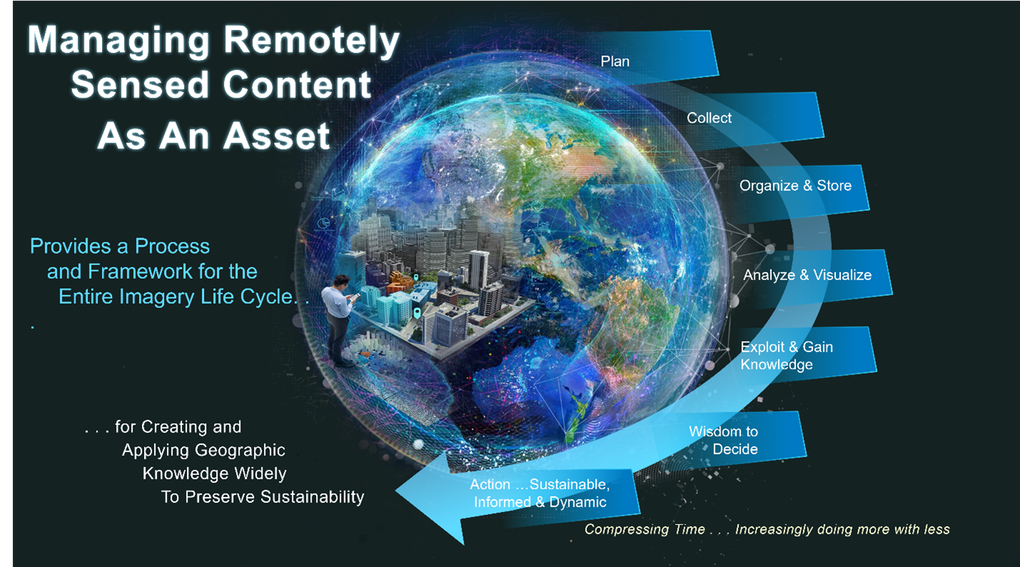
Managing imagery from collection to value
Effectively managing imagery throughout its lifecycle, particularly in enterprise environments, requires a clear and decisive approach. When utilizing content from satellites, aircraft, drones, or terrestrial sensors that provide imagery, lidar, or thermal energy, you are actively capturing reality. If your goal is to visualize a digital representation of your reality, gain knowledge, or make informed decisions, your content must be authoritative. Without authoritative content, your decisions will lack accuracy. Essentially, the question “why imagery” should be based on the need to provide an accurate and authoritative representation of our world.
To effectively grow remote sensing assets, it is important to follow a systematic approach. This includes:
- Planning and collecting data: Identify the specific needs of your applications and plan the data collection process accordingly. This may involve selecting suitable sensors, determining optimal flight paths or satellite orbits, and considering factors like resolution, coverage, and temporal frequency.
- Organizing and storing data: Once collected, it is crucial to organize and store the data in a structured manner. This ensures easy accessibility and efficient retrieval when needed. Consider using a data management system or a geospatial database to store the data. It is also important to establish appropriate metadata and indexing to facilitate search and retrieval.
- Automated analysis and visualization: Leverage automation tools and algorithms to perform analysis on the collected data. This can include image classification, change detection, feature extraction, and spatial modeling. Additionally, utilize visualization techniques to effectively communicate the results. This can involve creating maps, charts, or interactive visualizations.
- Gaining knowledge and wisdom: Continuously learn from the analysis and visualization results to gain insights and knowledge. This knowledge can then be applied to make informed decisions and derive actionable intelligence.
By following these steps, you can ensure that your remote sensing assets are effectively utilized and contribute to the success of your applications.
A picture is worth a thousand words…
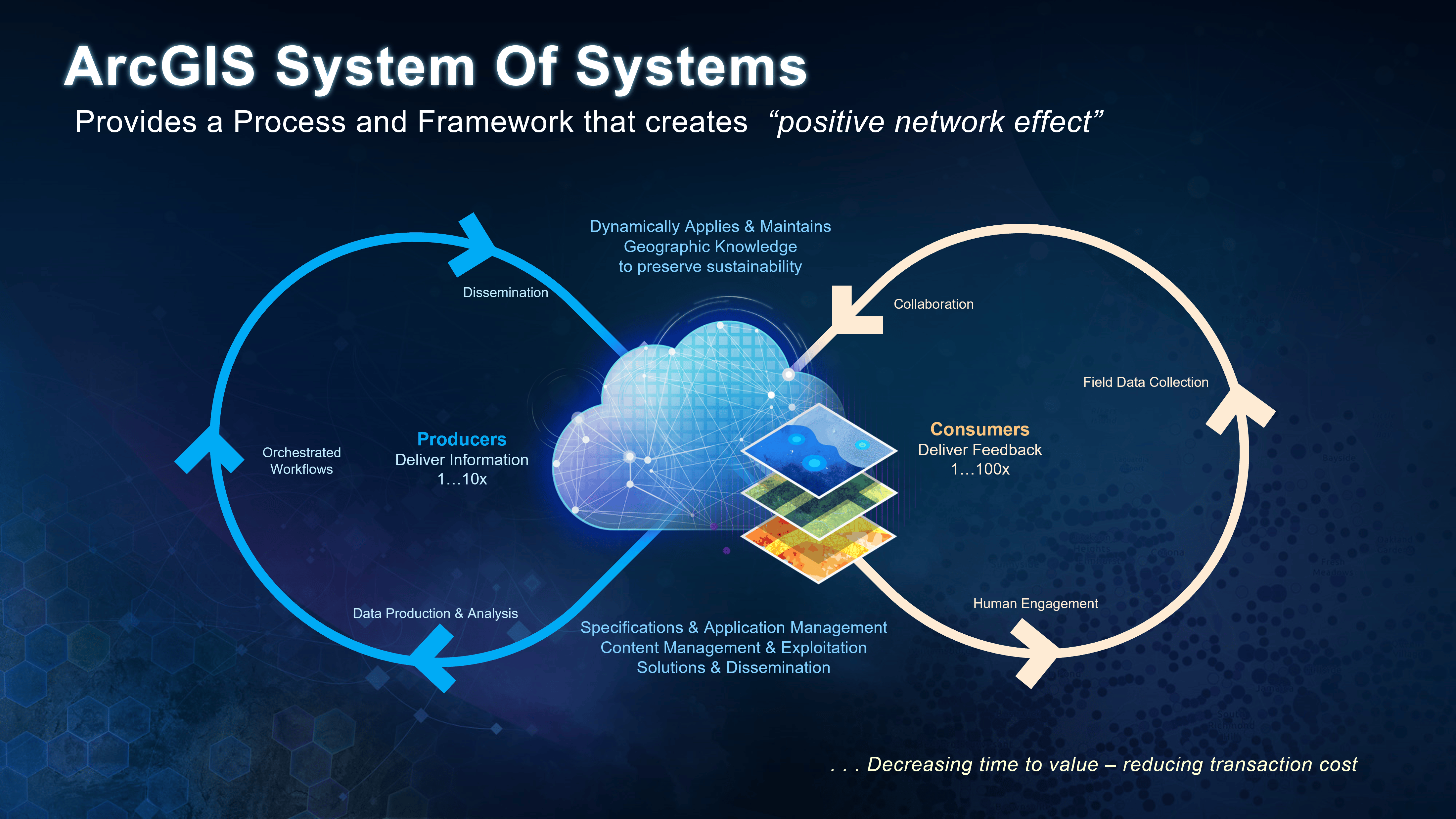
Leveraging imagery assets
Successfully leveraging imagery assets allows for the compression or reduction of the time required to derive value from their use. This compression not only reduces the time to value but also enables you to accomplish more with less. While the value of capturing and storing big imagery data is widely recognized, the process of managing this big “pixel data” may feel, well, big. If you’re feeling overwhelmed by this challenge, you’re not alone.
This series is dedicated to addressing this issue and providing guidance so you can successfully tackle the challenge. Our goal is to outline the important steps, from beginning to end, that will set you on a path to successfully transform – and exploit- your imagery/data so it becomes a valuable enterprise asset. Plan. Acquire. Process. Manage. Publish. Apply. Repeat. Our vision is to empower you to succeed by providing assistance in utilizing the ArcGIS system of systems effectively, regardless of your skill level. This will enable you to enhance and expand your imagery assets while also reducing the time required to achieve valuable outcomes. By compressing time, you can allocate the saved time to other important tasks and responsibilities. Subsequent blogs will dive more deeply into each outlined step.
How does imagery help my organization
Imagery provides an irreplaceable foundation for a wide range of applications, especially the business of governance, agriculture, and land records management, urban planning, disaster management, environmental monitoring, and defense, to name just half a dozen.
The ArcGIS system of systems is a platform to help you, providing efficient and secure access, management, visualization, and exploitation of your critical imagery assets. To illustrate that, let’s look a little closer at imagery management from the business side by discussing “network effects.”

Article Discussion: