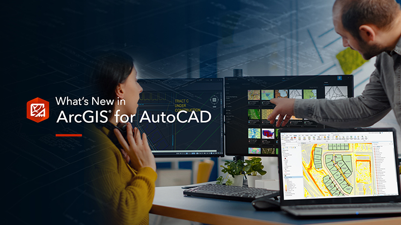
Are you responsible for ensuring your team’s CAD workflows are efficient, maintain proper standards, and incorporate accurate and relevant data? Did you know that you can integrate geographic information systems (GIS) into your work without disrupting your team’s established workflows, providing them with authoritative geospatial data, for better-informed decision-making?
ArcGIS for AutoCAD is an app for Autodesk AutoCAD and Civil 3D that enables CAD professionals to participate in the GIS process, all from within their familiar CAD environment. Inform designs with trusted geospatial data, reduce rework, and better collaborate with your GIS counterparts for information sharing. Let’s look at three example workflows bringing GIS into the CAD environment.
Adding geographic context to your CAD drawings
GIS coordinate systems allow CAD professionals to geolocate their drawing, identifying where the drawing is located relative to the surface of the earth. With ArcGIS for AutoCAD, adding a GIS coordinate system is simple, and does not interfere with your CAD workflows.
ArcGIS for AutoCAD provides several options for assigning coordinate systems to your drawings. These include keyword search, specifying a well-known ID (WKID), supplying a custom coordinate system, and even just carrying over the coordinate system assigned using built-in functionality from your desktop design tool.
Check out the video below to see how it is done.
Now you’ve added a GIS coordinate system to your drawing. What next? Well, the drawing is ready to add curated geospatial data. See your drawing in context with real-world, satellite imagery by adding an Esri map. Search for map layers from the ArcGIS Living Atlas of the World to gain a better understanding of the environment around your drawing such as soil information, property boundaries, wetlands areas, and U.S. Electric Power Transmission Lines. Further, incorporate publicly available layers such as the FEMA National Flood Hazard Layer (NFHL).
Does your organization have GIS? Get data directly from your own organization’s GIS database by logging into ArcGIS Online or ArcGIS Enterprise within ArcGIS for AutoCAD to bring in web feature layers directly to your drawings.
GIS in design and field workflows
Imagine you’re a civil engineer, and to take the next step in your project efforts, you need information that can only be gathered out in the field. To ensure the project delivery goes smoothly, you need up-to-date site information, and with ArcGIS for AutoCAD, you can have the up-date-information with geospatial context.
Publish feature layers from your drawing using ArcGIS for AutoCAD, which are then consumed by the mobile worker while visiting the project site. Then, using ArcGIS Field Maps, the mobile worker adds attributed geometry and even attachments to the layers. Updates to the layers are then published, and you synchronize these updates from within your CAD environment. You now have the information you need to keep moving forward.
Check out this video below to see how this workflow is carried out across the office and field using ArcGIS.
Industry specific templates to streamline workflows
Using ArcGIS for AutoCAD, you can easily create templates for industry-specific workflows like water and electric utilities, public safety, and natural resources. These templates allow CAD managers to provide their CAD technicians with stored coordinate system definitions, web and document feature layer definitions, project areas, web map and image layers along with all the standard CAD layer definitions and block symbology.
Now the CAD user is a direct participant in the GIS process and can edit GIS data and attributes right within their AutoCAD or Civil 3D drawing, with their traditional workflows uninterrupted.
Check out the video below to learn more about ArcGIS for AutoCAD template feature layers, which jumpstart template creation, and the value that comes with organizing your CAD drawings more like GIS.
CAD and GIS working together
GIS is a system that creates, manages, analyzes, and maps all types of data. ArcGIS for AutoCAD allows CAD professionals to use GIS data directly within their AutoCAD workflows, informing designs with spatial context. CAD drawings integrated with GIS can serve as a system of record between CAD and GIS professionals, with two-way data synchronization between AutoCAD and ArcGIS. You participate in the GIS process without leaving your tool of choice, be it AutoCAD or Civil 3D, and extend the value of CAD as a dataset that can be consumed throughout ArcGIS.
Download ArcGIS for AutoCAD today at no cost to start integrating GIS into your CAD workflows!


Article Discussion: