In the ArcGIS Business Analyst Pro 3.2 release, enhancements have been made to Territory Design. Territory design tools and workflows are included with ArcGIS Business Analyst Pro and allow you to create territory solutions. A territory solution contains everything you need to create, automatically balance, and modify point-based or boundary-based territories for any scenario, such as building sales regions or identifying franchise boundaries by ZIP code. These updates improve the manual territory editing process. The following is a brief overview of what to expect with the latest software version.
Redesigned Modify Territories pane
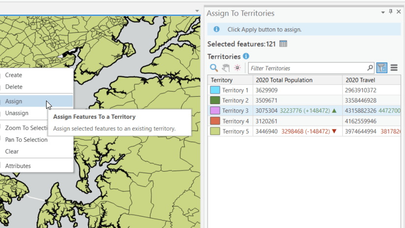
The Assign Territories pane is now named the Modify Territories pane. This pane is redesigned to include support for locking and unlocking territories, viewing base feature attributes, and other common territory management capabilities.

As you edit territories, you’ll find all the common territory management commands in one place in the Modify Territories pane, like Assign, Unassign, Create, and Delete. These commands were previously located on the ribbon; however, they are now more conveniently grouped with other similar features for managing territories.

Locking and unlocking
The process of locking and unlocking entire territories is now available in the Modify Territories pane. Find a territory and click the lock/unlock button. Previously, the only way to do this was through the attribute table. Territory centers can also be locked and unlocked.

You can also lock and unlock selected base features in the map using the context menu. This is helpful when you want to freeze a few underlying ZIP codes and not the entire territory. When territories are re-solved, locked territories never change assignments.

Explore base features
Speaking of base features, the Modify Territories pane allows you to drill into territories and view their underlying geographies and attributes. In the example below, base features are selected in the map and interactive. Learn more about each individual feature and their statistics on the Modify Territories pane. Previously, the only way to do this was through the attribute table. Another advantage of this is that the symbology for the base features and territories in the pane corresponds to the map.

New parent column
And finally, the Modify Territories pane now includes a parent column. The parent column shows territory hierarchy assignments at each level. For example, you can see which territories belong to districts, or which districts belong to national regions. In the image below, for example, the Smith territory belongs to Zone 1. At the lowest level, the parent column shows which individual base features belong to territories. This is helpful as all levels in a territory solution are built from the base features level.

We are excited about these new features and are already working on the next round of updates. If you have feedback or ideas for Business Analyst, check out the Esri Community and consider adding an ArcGIS Business Analyst Idea.


Article Discussion: