Another CityEngine release is already upon us! We changed our release cycle this year so CityEngine 2018.0 released last week, a full three months earlier than usual. This means that while there aren’t a ton of new features, you can now enjoy new versions of CityEngine sooner. So you can expect to see CityEngine 2018.1 sometime in early Q3 instead of November. Take a look below to find out about just some of our release highlights. You can learn more about all of our new features and fixes in the 2018.0 release notes. Go to My Esri to upgrade to CityEngine 2018.0.Or, if you are new to CityEngine, try it out now with a fully functional free trial version.
Instant quantitative visibility assessments
With CityEngine 2017.1, we introduced Visibility Tools that give you insight into what is visible in your city from a given viewpoint. In the 2018.0 release, we take this feature a step further by adding Statistics for the Viewshed and View Dome tools. Finally, all your questions about visibility assessment like, “How much of Central Park can I see from my Manhattan hotel room?” or “How much ocean view will I have from my balcony in my future Miami Beach apartment?” can be precisely answered. With the new interactive statistical outputs of the Viewshed and View Dome tools, you can calculate quantitative visibility assessments in a split second. These tools allow planners to compare the impact of development scenarios on vistas to the city’s landmarks, and real estate developers can now quantify visibility qualities as inputs to their assessment valuation models.

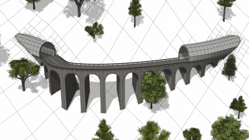
Modeling on curved shapes
The release highlight for the CGA language is the introduction of the insertAlongUV operation. With this operation, you can wrap arbitrary 3D models around any polygonal surface with texture coordinates. This allows you to bend 3D models such as guard railings, tunnel panels, or arches along curved streets, or generate contemporary architecture by populating window or shadow panels over free-form surfaces.
Premium VR experience for urban planning reviews
With CityEngine 2018.0, we strengthen our investment in game engines. Unreal Studio, the new royalty-free tool for enterprise workflows with the Unreal engine, will feature two new templates for CityEngine users. The first template allows you to visualize CityEngine data in real-time. The other template, which will be published soon, allows urban planners to easily create premium VR experiences (HTC Vive). This template works with CityEngine data set up in a given hierarchy and provides an intuitive table-top experience where you can review design scenarios in an immersive setting.

…and one more thing
CityEngine is now available with a Chinese user interface. Welcome procedural modeling enthusiasts from China!
PS – Follow Esri CityEngine & Geodesign on Facebook, Twitter, and Instagram.

Commenting is not enabled for this article.