
The holiday season is the busiest time for organizations managing fleets and handling all kinds of delivery operations. From cross-city moves to last-minute holiday orders, companies are constantly challenged to improve efficiency, ensuring goods arrive at their destination on time and drivers adhere to plans, all with the goal of elevating customer satisfaction, increasing cost savings, and optimizing asset utilization.
Esri’s routing service is fundamental for achieving success with routing processes. Two operations of the ArcGIS Routing service, Last-Mile Delivery and Snap to Roads, are particularly beneficial for organizations seeking to enhance their routing applications and solutions this season.
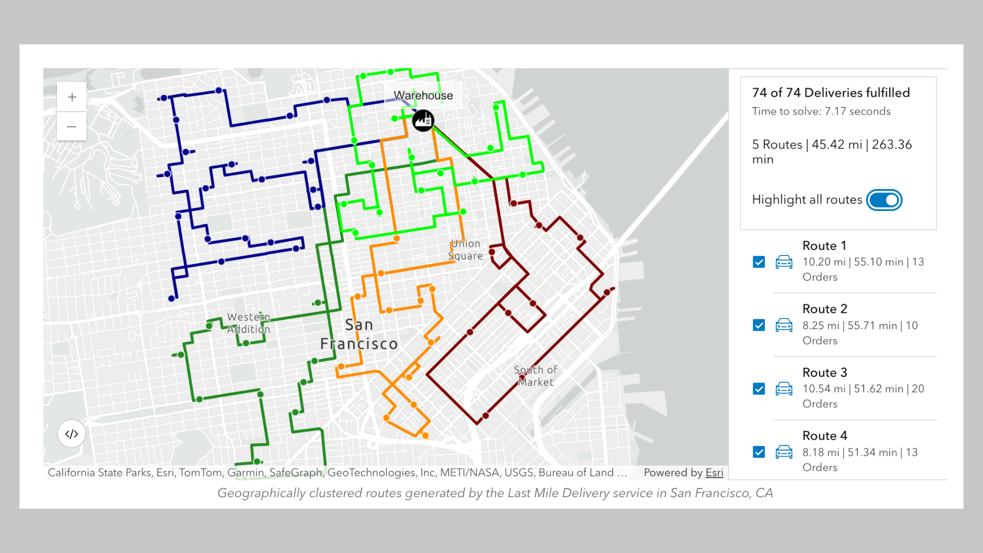
Last–Mile Delivery solves complex challenges often associated with the final leg of delivery. An e-commerce company may dispatch three or more drivers to fulfill multiple orders for each customer who made a purchase during a holiday sale. The drivers may be expected to deliver packages to multiple locations within a major city. Without an effective solution designed to solve fleet routing problems, drivers may lack optimal routes to collectively fulfill these orders.
Esri’s Last-Mile Delivery solution addresses this by providing geographically clustered routes, enabling drivers to deliver to customer locations in close proximity to each other. It supports route planning, ensuring drivers have the most efficient delivery path, thereby reducing the time spent on the road.
At a time when companies in logistics and retail tend to experience a surge in order volumes, decreasing operational costs through smarter routing techniques, such as leveraging the Last-Mile Delivery operation, can support organizations in making smarter decisions during the holiday season.
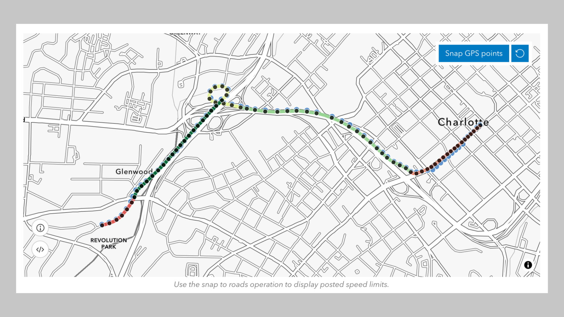
The Snap to Roads operation supports fleet and driver monitoring, contributing to improved route planning, analysis, and adherence. It aligns GPS points to road segments, improving the accuracy of GPS information and making it easier for businesses to determine the appropriate delivery routes. Operators within organizations who are managing routing solutions can see what routes drivers have taken and can also compare GPS attributes such as speed with road characteristics like speed limits.
This is helpful for reporting speed limit violations by drivers that could ultimately impact the safe fulfillment of orders. It could also help to ensure that organizations stay compliant, ultimately helping them mitigate risks and reduce costs associated with traffic violations.
By providing reusable routes for future deliveries, Snap to Roads increases productivity for drivers and saves them time. Additionally, it helps businesses efficiently navigate delivery routes and conserve resources such as fuel or vehicle maintenance costs.
How Can Businesses Utilize These Operations?

Developers building or enhancing routing applications and solutions that power deliveries can simply integrate these functionalities. To get started, they can sign into an ArcGIS Location Platform or ArcGIS Online account.
For detailed information on how to use Snap to Roads or Last Mile Delivery, please explore the following Esri Developer guides:
Discover other helpful topics such as building a routing service application and more.
Subscribe to the Esri Developer Newsletter to discover more developer offerings and updates.


Article Discussion: