
In this episode of Developer’s Lounge, Luke Smallwood, a software development team lead at Esri, reflects on his own journey as a developer and offers a behind-the-scenes look at how his team is shaping the future of geospatial AI.
With the recent release of ArcGIS Location Platform, the team is extending ArcGIS capabilities to Model Context Protocol (MCP) clients, giving developers broader access to location services and accelerating the pace at which they can build and deploy applications. It’s a significant step in Esri’s ongoing mission to bring the power of ArcGIS to new platforms and audiences.
In this conversation, Luke takes us deeper into his team’s work — the problems they’re solving, the vision driving their decisions, and what it means for developers embracing AI-driven workflows.
"For me, the key point about the MCP support for ArcGIS Location Services is that it gives users easy access to location insights. Without writing a single line of code, you can empower an agent to answer questions about a location of interest. That brings the power of spatial information to new audiences with as little friction as possible." - Luke Smallwood
1. Hello, Luke! What’s the story behind your first line of code, and how did it lead you to where you are today?
I did some BBC BASIC back in high school, and the main thing I took away was the importance of leaving gaps between the numbers of your lines, so you could insert something later without having to update the entire code.
The first time I remember being really excited about coding was in a Java module as part of my GIS masters at university. We were introduced to some of the concepts of Object-Oriented Programming, with the exercise being to model a goldfish. Ironically, my memory of the goldfish program is pretty hazy, but I do remember excitedly showing my partner that I could type in a number to feed the fish, and it would get bigger. Somehow, she failed to grasp the full significance of that but here I am twenty something years later, still feeding those fish!
At Esri, I am a Group Software Development Lead tasked with creating developer-focused location services. I collaborate with devOps, software, and product engineers to develop full-stack solutions that scale to meet our customers’ needs. My role involves a huge amount of variety, including:
- API design
- Writing code or tests
- Meeting users and requirements gathering
- Preparing user documentation and example apps
I really love the fact that each day is different and that I get to collaborate with a great bunch of people to solve new and challenging problems.
2. One of the major projects your team has been working on is exposing ArcGIS Location Services to Model Context Protocol (MCP) clients. Can you share how this began and why you believe there is a need for it?
My team builds location services for developers. One of our key missions has always been to share the amazing GIS functionality that Esri creates with new users. In the past we’ve looked to make new RESTful APIs as developer friendly as possible by adopting standards like OpenAPI but we’re always on the look-out for ways to make things more accessible.
MCP is a game-changer in that space, because the protocol means that any client can instantly learn about and access our technology. And for me, the really powerful part is that, by following this protocol, we can collaborate with AI technologies to offer a clear, structured API over our authoritative RESTful services. That means less work is left to an AI to figure out for itself, and results can be more accurate and more predictable for the end user.
As to how we got started with MCP, it actually grew out of an R&D project that some of our engineers picked up at the end of 2025 because they thought it sounded kind of cool. Then we looked at what they had built, and we all started to think it sounded interesting. And the more we looked into it, we started thinking it was actually quite important. We started speaking to users about it and realized it was going to be essential.
Learning about MCP, and the AI landscape, has been a huge learning curve for my team – but it’s something that we are really excited to share with users.
3. What location services are currently being exposed to MCP clients?
At the moment, we are focusing on empowering MCP agents with a broad set of functionality that covers the range of location services at Esri. We’ve got tools that provide:
- Geocoding
- Reverse Geocoding
- Route Finding
- Elevation
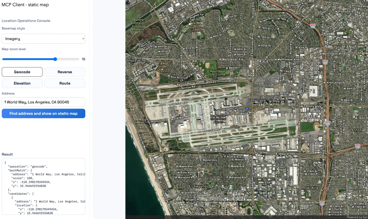
- Displaying on a static map
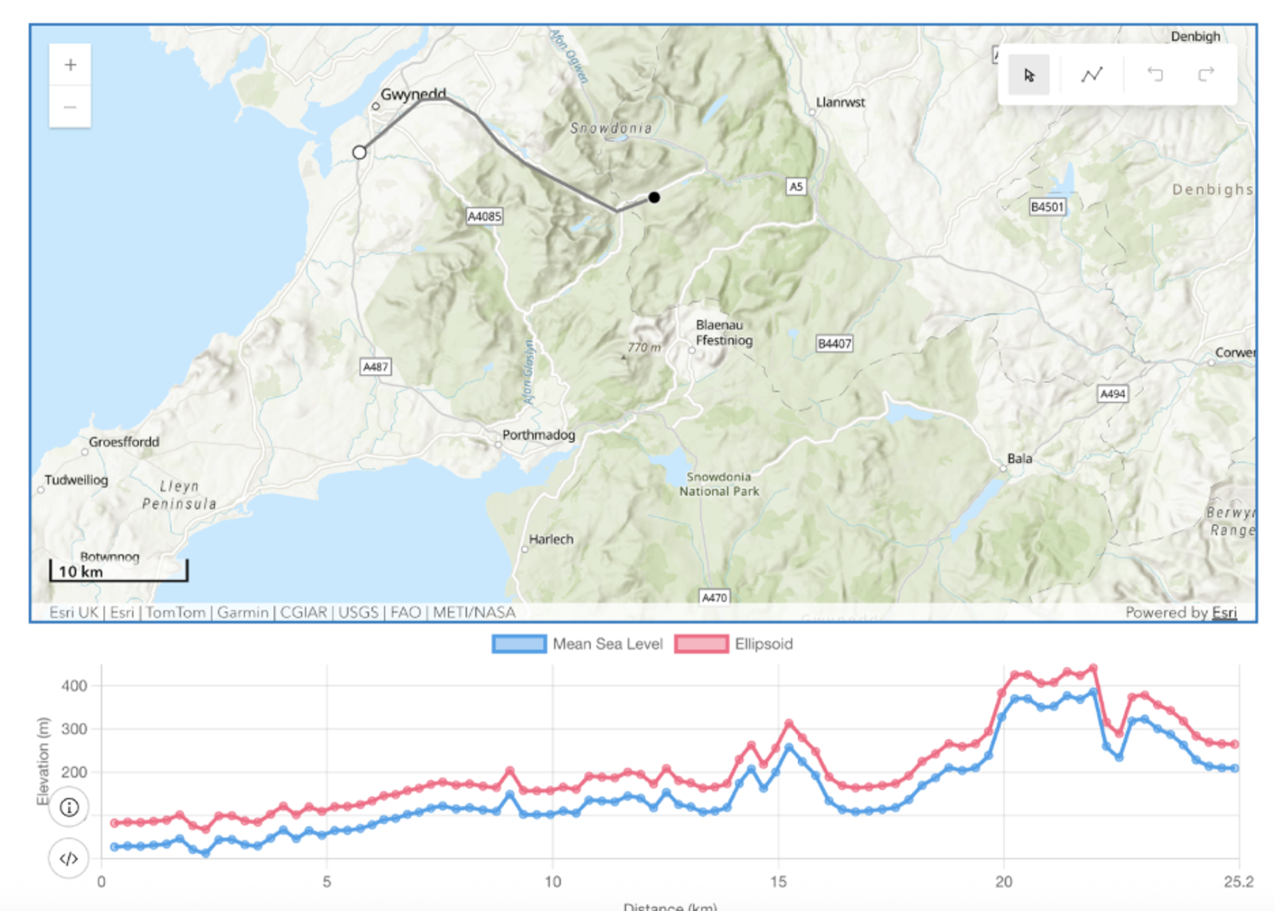
We’ll be rolling out additional features and capabilities from other services (such as GeoEnrichment and place finding) in the coming months – so join the Early Adopter Community and stay tuned!
4. Why do you think this is important to developers and their AI workflows?
For me, the key point about the MCP support for ArcGIS Location Services is that it gives users easy access to location insights. Without writing a single line of code, you can empower an agent to answer questions about a location of interest. That brings the power of spatial information to new audiences with as little friction as possible.
We are concentrating on building something that is standard-compliant, secure, hosted and backed by our detailed knowledge of the underlying technology. We’re doing the hard work so that all a developer needs to do is point their MCP client at the URL, provide authentication and they have access to location intelligence.
5. Could you provide some practical examples for prompts developers can use to be more effective as they leverage this offering?
A real light-bulb moment for me was understanding that a single prompt can access several of our tools in one go. To begin with, if I wanted to display a route map, I would spoon feed the agent by asking:
- “What are the coordinates of this address?”
- “What are the coordinates of that address?” and then,
- “Can you give me a route from this coordinate to that one?” and finally,
- “Show me this polyline on a map”.
That worked, but with access to all the tools, the agent can combine them much more effectively if I just say: “Give me a map of the route from this address to that one”.
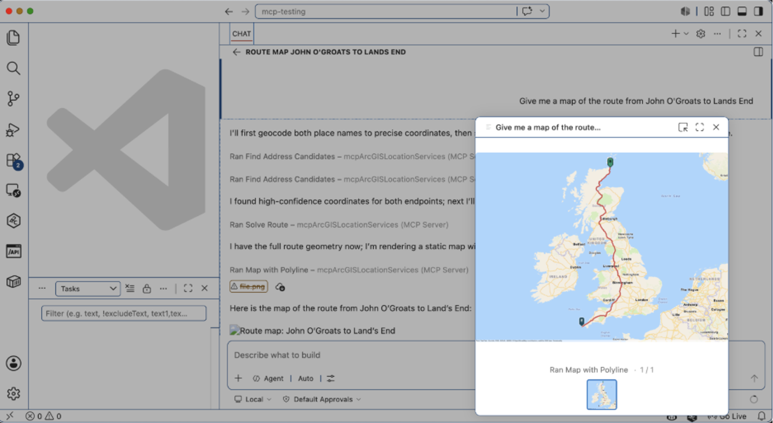
Some other good prompts are:
- What is the elevation of {address}?
- What is the highest point on the route from {start_address} to {end_address}?
- Show me these addresses on a map, {address 1}, {address 2}
You can see more details of these example prompts on our documentation site.
6. How can developers access the MCP server to add geospatial capabilities from ArcGIS to their workflow?
Our documentation guides provide a great place to get started: they walk you through setting up authentication and have examples for configuring a range of clients such as GitHub Copilot, m365 and Claude. I’d also recommend that people check out the Model Context Protocol Getting Started page for an overview of the technology.
Here’s an example of connecting the MCP for ArcGIS Location Services to AWS Bedrock:
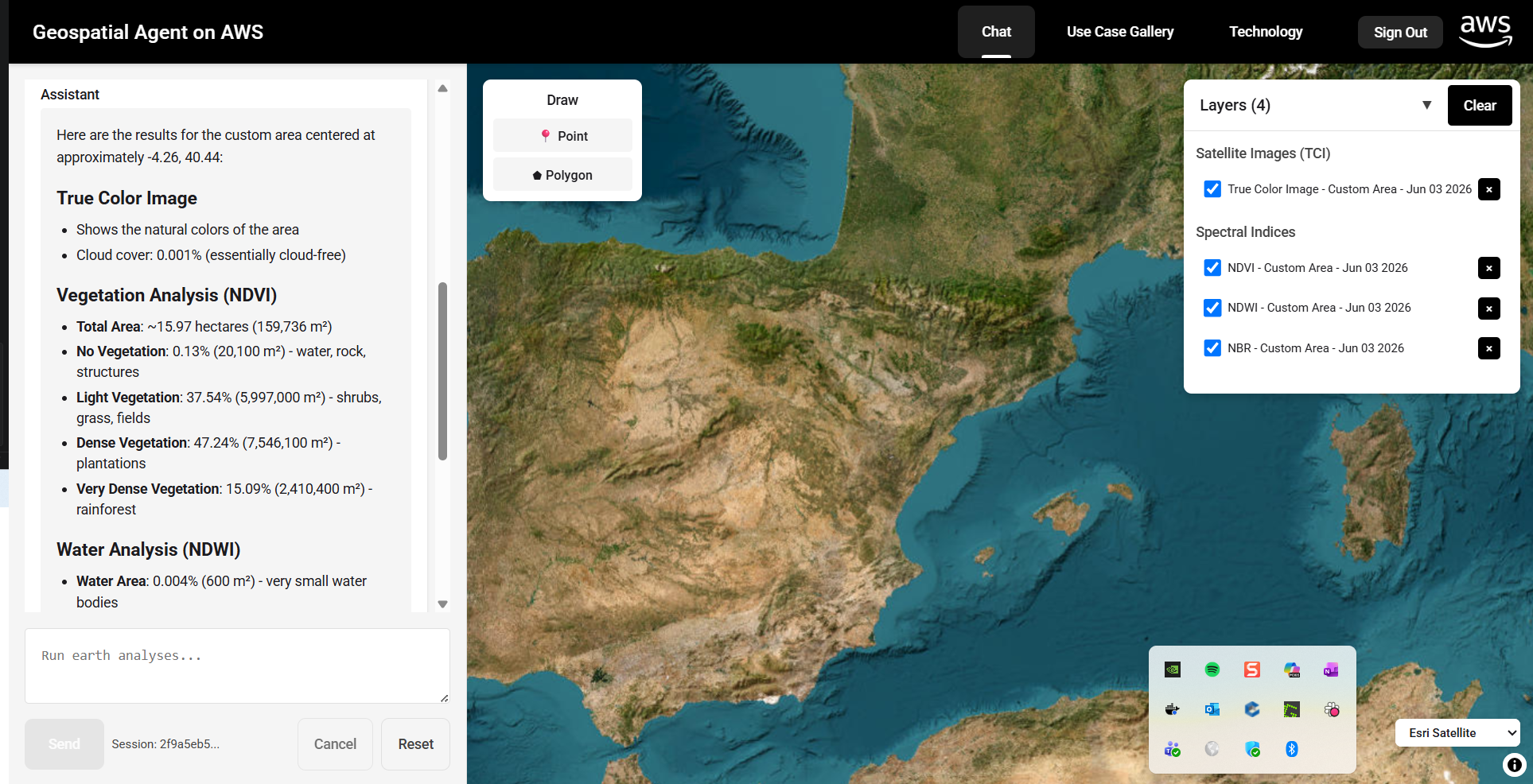
7. MCP support for ArcGIS Location Services is currently in beta. What does this mean for users, and how can they test the functionality?
The best way to get access to MCP support for ArcGIS Location Services is to join the Early Adopter Community. It includes useful resources to get you started and also has various feedback mechanisms so you can get in touch with the development team.
MCP support for ArcGIS Location Services is in beta because we want to make sure that what we are building meets our users’ expectations – the more feedback we receive, the better. The functionality is in beta, so we may change the way that some tools are implemented, but we don’t plan to remove capabilities. The great thing about MCP is that every time your client connects it gets initialized with the latest set of tools, so you don’t need to do anything to stay up to date.
One thing to call out is, although the MCP is in beta, the underlying location services are not, so you will be charged for usage against those in the normal way.
8. Is there anything else about MCP support for ArcGIS Location Services that you would like to share with our audience?
I’d also like to mention that there is a parallel MCP effort underway at Esri which you can access via the same Early Adopters Community. MCP support for ArcGIS Enterprise focuses on exposing GIS capabilities from an organization’s enterprise deployment to an MCP client.
Our project sits alongside that (in fact you can combine the two into a single session) and it gives you access to global, authoritative data to help you make better informed decisions about location.
Look out for more interviews in our Developer’s Lounge series!

Don’t forget to subscribe to the Esri Developer Newsletter and follow Esri Developers on LinkedIn to discover more developer offerings and updates.




Hello,
Nice CV and nice article!
Just wondering how you render your map in VS Code with Give me a map of the route from this address to that one