Note: If you have reached this blog post from the Having a bad case of vertigo post and want to learn more about what’s causing these issues, you can skip ahead to the Further education section.
RTK drones are a great addition to high-grade surveying workflows because they allow you to cover a large area quickly and with high precision to help meet your clients’ requirements. What happens, though, when you process your imagery in ArcGIS Drone2Map or Site Scan for ArcGIS and then your output elevation model values are very different from the basemap’s elevation layer? Or you notice that the 3D textured mesh sinks far below the surface, or hovers above it?
To understand why this may be happening, you need to first understand the basic definitions of vertical heights and the different vertical systems. A detailed explanation is provided in the Further education section below, but to summarize it, we can say that some RTK systems offer ellipsoidal or orthometric height values, or both, and it’s important to review your user manual (or contact your vendor) to understand which values are shown.
Esri elevation layers always reference orthometric height values. If your drone collects data in ellipsoidal heights, this may be one of the reasons your outputs differ from the elevation layer. Most clients would probably like to work with orthometric heights (above sea level), since that is the most common system in use today.
You can check if your RTK values are refencing an orthometric or ellipsoidal datum by using the Sample Heights for World Terrain map. Navigate to the location of your project area and click any pixel:
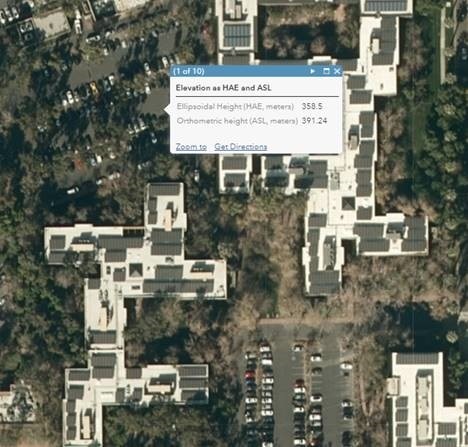
A pop-up window will show the elevation values of that location in ellipsoidal and orthometric heights.
If you are not able to change the values by configuring your drone’s RTK hardware, you can configure Drone2Map to import the image metadata with ellipsoidal heights (see the choose a vertical reference section in the Vertical reference topic in the Drone2Map help). If you are working in Site Scan, after uploading the images and before you start processing, you can set the input image vertical datum to a specific ellipsoid datum, and then the output to a specific orthometric datum. If you are trying to add your output products to an ArcGIS Online Scene, please be aware that it uses ellipsoidal heights from the EGM96 ellipsoid so make sure your Z values are using the same datum.
Overall, when you collect imagery with drones and RTK, it is crucial to understand which reference system your hardware generates and what system is required by your client. If you need to convert your system, the general recommendation is to configure your hardware accordingly, or set the image altitude values to the desired system.
Co-authors: Cody Benkelman, Mark Barker, Taren Woelk
Further education
Let’s review the literature regarding vertical reference and the different vertical datums. But first, we need to cover some basic terms:
Vertical coordinate system—Defines the reference for height values and ensures the data is vertically located in relation to other data.
Vertical datum—A surface to which the vertical coordinate system is referenced. Two types of surfaces can be used: ellipsoidal (spheroidal) or orthometric (geoidal/gravity related).
Geoid—An equipotential, or level, surface of the earth’s gravity field, which is approximately the mean sea level (MSL). The geoid is influenced by the composition of the earth, so it has nonuniformities in its slope, considering its surface is an analytic surface as opposed to a mathematical surface (ellipsoid).
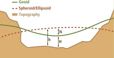
In the illustration above, the green line represents the geoid surface. It gently curves to follow the topography. The dashed line represents the surface of the ellipsoid. The h is the height above the ellipsoid (HAE). In this case, height is a negative value. Geoid undulation, N, is the distance between the spheroid and geoid surface. The orthometric height, H, is related to the ellipsoid height by the following:
h = H+N
If your head is spinning, that’s OK—this topic is complicated, and researchers are working hard on better understanding and calculating geoid undulation and the earth’s gravitational field.
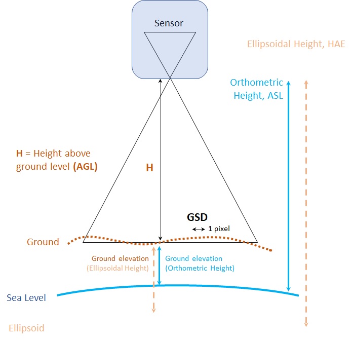
It’s important to understand that there can be many different height values:
- Height above ground (AGL) — In this case, you or your client are interested in seeing only the difference in elevation values between two points on the surface, point clouds, or 3D mesh created in the software.
- Orthometric height (ASL) — In this case, you are looking for the height above sea level, which is how we usually describe heights of objects. This height is generally used when describing the heights of natural features, for example, the height of Mount Everest—29,032 feet (8,848 meters) —or Mount Kilimanjaro—19,341 feet (5,899 meters).
- Ellipsoidal height — This case is rarely requested but may come up with some clients who choose to work in a separate, custom vertical system. Ellipsoidal height is the native measurement made by GPS, but in most cases, GPS values are translated to orthometric height. If you have GPS data from a surveyor (for example, for ground control points), you’ll want to verify if it is expressed as ellipsoidal or orthometric height.
The following diagram illustrates the different heights:

Thanks for the great summary. Many people think the world is round (vs the Oblate Spheroid it really is). I found this 3D print file from NASA to be a great way to show people why it is so hard to get an accurate Z value. (3D model here)
Thank you for this article. We have been using D2M with a Phantom4 Drone (without RTK – however with Ground Control Points) – and elevation always turned out to be perfect.
Now we bought a DJI Mavic 3 Enterprise RTK Drone (using SAPOS GNSS correction service in Germany) in conjuction with GNSS surveyed ground control points and we have terrible trouble regarding elevation in D2M (Sitescan seems to do a lot better)
For one thing we don’t find the M3E in the pulldown list of supported drones/cameras. Are we looking at the right place? or is just missing?
Any help would be greatly appreciated. (ole.seidel@alta4.com)