ArcGIS Excalibur, transforms the way analysts search, discover, and work with imagery—all in a web-based app. Excalibur modernizes and enhances image-based workflows by unifying traditionally separate geospatial and imagery-based views into a single integrated experience. With an easy-to-use, web-based experience, Excalibur has the power to improve daily decision-making across different organizations.
The December 2020 release ArcGIS Excalibur enhances ways in which users access imagery and introduces new capabilities that improve management of observation collection workflows.
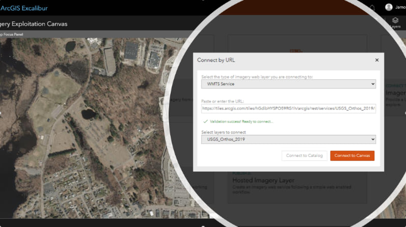
Access imagery or Web Map Tile Services
ArcGIS Excalibur continues to expand support to Open Geospatial Consortium (OGC) standards. With a single click, users can easily access Web Map Tile Services (WMTS), enabling analysts to work with a common type of raster content that offers high performance and increases scalability. Accessing WMTS makes it easier for analysts to complete simple exploitation tasks.
Saved Searched Queries
To gain quick access to imagery, analysts can create and save user-defined search queries from their active imagery search. This newly implemented single-click experience enhances the imagery search and discovery workflow.

Batch Editing Observations
Using the new Batch Edit Observation Tool, users can select and make changes to multiple observations – improve productivity by saving time during the quality review process.
Stay in the Know
ArcGIS Excalibur continues to transform imagery workflows through constant improvements in response to customer input and expanding capability of ArcGIS. To learn more about Excalibur and add it to your organization’s ArcGIS Enterprise deployment, get in touch with an Esri representative at go.esri.com/excalibur or visit our YouTube Playlist.


Article Discussion: