
Background
The Washington Surveying and Rating Bureau (WSRB) is a not-for-profit organization that provides accurate, objective data to support equitable insurance underwriting across Washington State. Through its subsidiary, BuildingMetrix, WSRB delivers actionable geospatial intelligence to insurers, emergency responders, and public safety agencies.
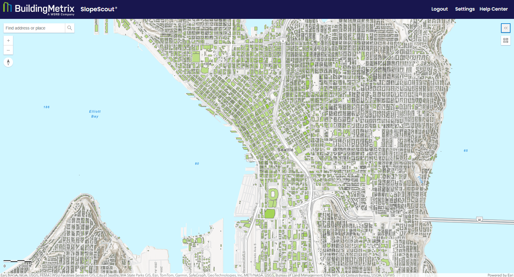
In partnership with GCS, WSRB and BuildingMetrix developed SlopeScout, a cloud-native platform that uses the ArcGIS ecosystem to deliver structure-specific slope and terrain risk analysis from a simple address lookup. Built on ArcGIS Enterprise, ArcGIS Server, and ArcGIS Maps SDK for JavaScript, SlopeScout automates workflows traditionally performed by GIS specialists, transforming how the insurance industry and emergency management agencies evaluate terrain-related risk.
The Challenge
Slope and elevation are critical yet consistently overlooked factors in property risk assessment. Properties on steep terrain face significantly higher exposure to landslides, debris flows, wildfires, and seismic events. Despite this, accessing and interpreting slope data has historically required specialized GIS expertise, placing it out of reach for most underwriters and emergency planners.
Insurers typically relied on static topographic maps or raw Digital Elevation Models (DEMs) that demanded manual interpretation, a process that was slow, inconsistent, and impossible to scale. No existing tool offered automated, address-specific slope analysis. Terrain insights were locked behind technical specialists, and meaningful integration into insurance workflows was virtually nonexistent. The result was risk evaluations built on incomplete data and emergency planners without the terrain intelligence needed to accurately identify and respond to hazards.
The Solution
WSRB and BuildingMetrix partnered with GCS to design and deploy SlopeScout, a web application built on Esri’s ArcGIS platform from the ground up. By harnessing the breadth and depth of the ArcGIS ecosystem, the team delivered an enterprise-grade solution quickly, without compromising on analytical rigor or user experience.
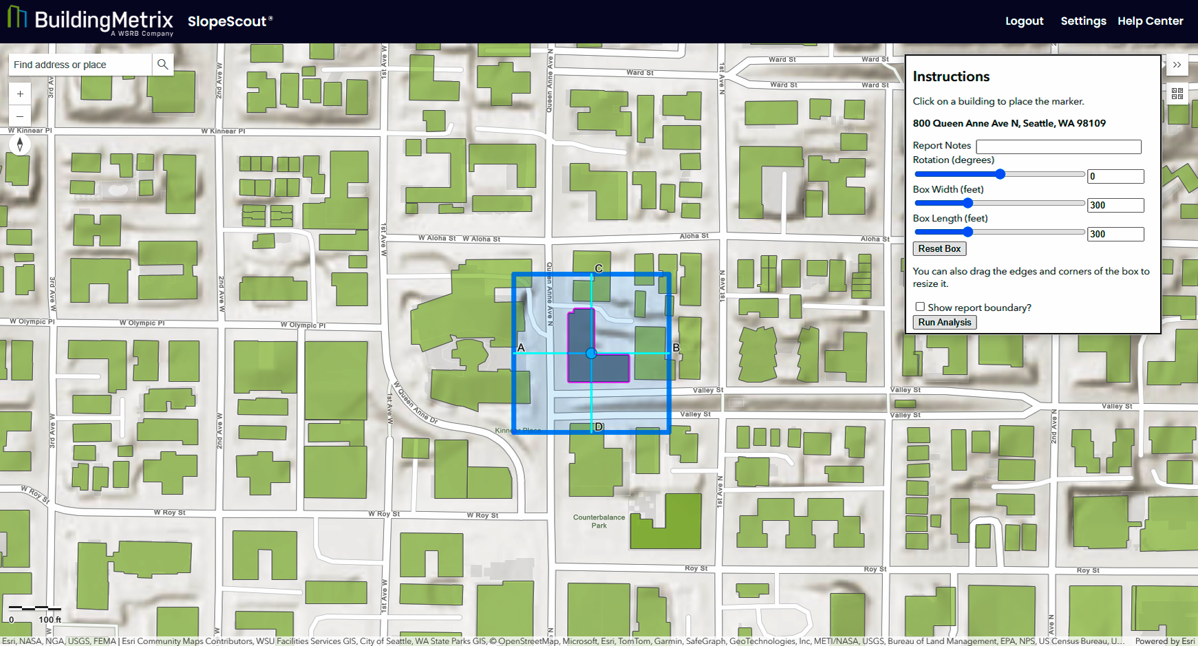
At the core of the platform, ArcGIS Enterprise and ArcGIS Server host secure Geoprocessing Services that automate slope calculations and terrain analytics at scale, eliminating the need for dedicated GIS teams. The interactive, web-based interface is built with the ArcGIS Maps SDK for JavaScript, enabling intuitive, address-based property lookup to anyone regardless of technical background. The backend geospatial processing is handled by ArcPy, with statewide high-resolution DEMs managed through Mosaic Datasets for seamless, consistent terrain coverage across Washington State. Dynamic, print-ready reports are generated using configured ArcGIS Print Templates, with rich cartographic context provided by ArcGIS Online basemaps.
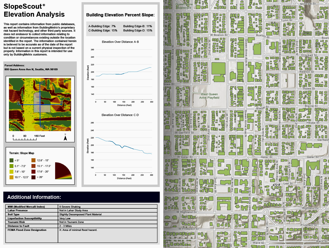
Together, these interconnected ArcGIS components form a secure, scalable, and low-maintenance cloud-native platform, showing how the ArcGIS ecosystem can support scalable, real-world operational workflows. Users simply enter a property address to instantly receive a downloadable report featuring slope heatmaps, elevation profiles, and building footprint overlays. Each report is further enriched with authoritative multi-hazard datasets including FEMA flood zones, seismic risk zones, lahar flows, fault lines, tsunami inundation zones, and soil liquefaction risk maps, giving decision-makers a comprehensive, multidimensional view of property exposure.
"Before SlopeScout, evaluating slope risk often required pulling information from multiple sources and manually interpreting terrain data. Using ArcGIS technology, we were able to build a web-based application and transform this once complex process into a practical workflow. SlopeScout empowers everyday users to harness fast, property-specific insight that previously required significant manual research and GIS expertise."
The Impact
By leveraging the power of ArcGIS, SlopeScout has fundamentally changed how terrain risk is evaluated across the insurance industry and public safety sectors.
For underwriters, the platform eliminates manual GIS analysis, dramatically reducing turnaround times and enabling faster, more accurate policy decisions. Insurers can now price policies for high-risk properties with greater precision, improving alignment with reinsurance models and creating fairer outcomes for policyholders. Professional-grade visualizations, made possible by ArcGIS’s robust mapping and reporting capabilities, strengthen documentation for both internal review and external stakeholders.
Beyond insurance, SlopeScout has become an essential tool for emergency management. Fire mitigation specialists use slope data to model fire behavior and prioritize defensible space strategies. Emergency planners integrate elevation insights directly into evacuation planning, improving community preparedness and response to natural disasters.
SlopeScout sets a new standard for accessible geospatial intelligence. Powered by the ArcGIS ecosystem, it demonstrates how Esri’s platform can bridge the gap between complex spatial science and everyday operational decision-making. The result is a scalable, future-ready solution that empowers insurers, public safety officials, and community planners to act with greater speed, precision, and confidence.
About the Parnter
GCS, an Esri Gold partner, is a geospatial information technology (IT) services company based in Missoula, MT. The team is comprised of geospatial IT and cloud-certified professionals who help organizations unlock and enable GIS technology. Since 2002, GCS has been an Esri Business Partner; and in 2022, GCS was recognized as an Esri Cornerstone Partner for twenty years of commitment to Esri and ArcGIS technology.
This article was co-authored by Fred Spataro, Vice President of Solutions, GCS. Fred Spataro leads the professional services team, ensuring the delivery of high-quality geospatial solutions tailored to client needs. With a wealth of experience dating back to 1996 working with Esri technology, Fred brings a deep understanding of the geospatial landscape.
This article was co-authored by Pavin Browne, Senior Content Strategist, Producer, and Videographer with WSRB. Pavin Browne has seven years of content writing experience across several industries. He has a passion for research and enjoys creating unique and thoughtful marketing content
Learn more about ArcGIS Maps SDK for JavaScript by visiting our page on esri.com or exploring our detailed documentation. Stay up-to-date with the latest releases, events, and educational resources by subscribing to the Esri Developer Newsletter. Connect with a community of web developers on our Esri Community pages and follow us on X (@EsriDevs) for real-time updates and insights.

Article Discussion: