Whether you’re building a logistics app, a consumer-facing product, or considering an internal business integration, location intelligence is often what separates a good experience from a great one. ArcGIS Location Platform gives organizations access to Esri’s market-leading location services through easy to deploy tools and authentication methods, no full GIS deployment required. Its consumption-based business model means you only pay for what you use, and a generous monthly usage allowance enables you to test and try services.
This blog article will walk you through the location capabilities available through ArcGIS Location Platform, where they fit into real-world applications, and what you can do with them. Jump to what interests you:
Maps
What are basemaps?
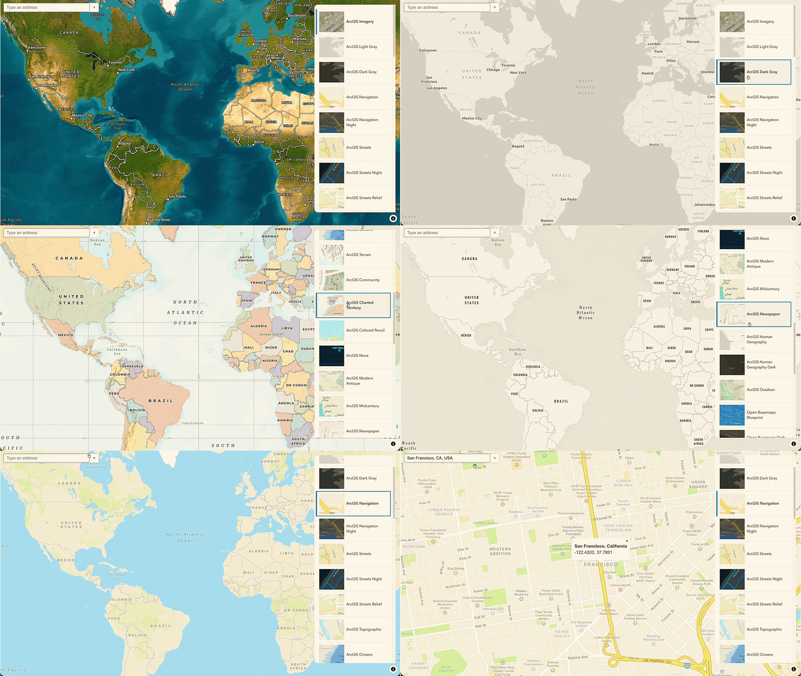
Most location-aware solutions need a map to orient the user. Basemaps are the geographic foundation your app is built on. They provide the visual context that makes data meaningfully rooted in a larger story. ArcGIS Location Platform gives you access to an extensive global collection of prestyled ready-to-use basemaps designed by Esri’s team of professional cartographers.
How do you use basemaps in an app?
An auto insurer might use a basemap to build a claims dashboard for adjusters reviewing accident scenes. Using a streets basemap, an adjuster could understand intersection geometry and traffic patterns at the crash location. Then switching to satellite imagery, they could check for visibility obstructions like trees or overpasses. If you have unique software or hardware requirements, you might consider leveraging static basemap tiles which keeps the services working quickly.
What can a basemaps service do?
The following is what you can do with basemaps in ArcGIS Location Platform:
- Select a map style. Choose the style that best fits your solution with the ArcGIS Basemap Styles service. Daytime and night-time navigation styles are available, as well as satellite imagery, or even mid-century style to transport users to another time.
- Display styles designed by Esri’s cartographers. Use ArcGIS Basemap styles to show authoritative data from Esri and partner providers.
- Access open data styles. Reference data from the Overture Maps Foundation (an open-data initiative of which Esri is a member), including streets, satellite, and more creative designs, with Open Basemap styles.
- Customize your basemap. Tailor the map to match your brand and audience:
- Style. Apply your own color scheme, emphasize or deemphasize geographic features or labels, use custom symbols, and change text fonts to match branding.
- Language & Localization. Select the language that is best for your app, with over 40 languages offered. Or use localization, to label locations with the local language’s name.
- Worldview. Display a country-specific view of disputed boundaries for an experience with your audience in mind.
- Get pre-rendered PNG map tiles. Use the ArcGIS Static Basemap Tiles service for low-bandwidth environments or clients without WebGL support.
- Create and embed static map images. Easily add static maps into your apps and solutions where an interactive map may not be ideal with the ArcGIS Static Maps service. Place points, lines, polygons, and multiple geometries.
Geocoding and Search
What is geocoding?
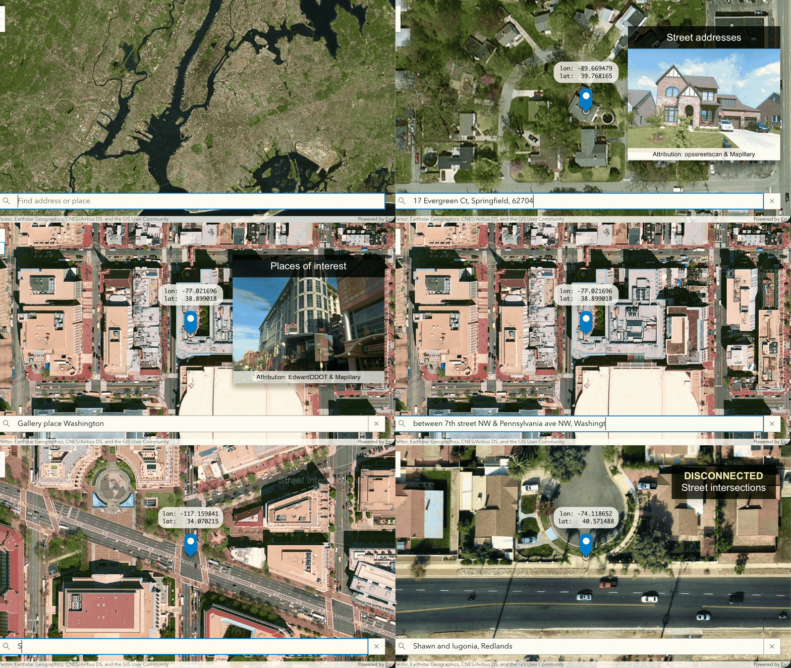
Geocoding is foundational to adding location capabilities to solutions. Any time a user types an address, or you need to place a point on a map, you’re typically relying on this service. ArcGIS Geocoding service converts addresses and place names into coordinates, and coordinates back into readable addresses. The service pulls from authoritative sources including community, commercial, and governmental data providers to support covering more than 90% of the world’s population.
How do you use geocoding in an app?
An e-commerce platform needs to validate customer addresses at checkout. As the user types, the autosuggest capability surfaces candidates in real time. Once an address is selected, the coordinates are stored in the order record and used downstream for routing and delivery tracking.
What does a geocoding service do?
The ArcGIS Geocoding service can do the following:
- Validate addresses. Built-in strategies verify, correct, and standardize address inputs for data quality with address validation.
- Convert a place name or address to a coordinate. Convert one or more addresses or place names into coordinates with geocoding. Returns a complete address, a precise location, and a ranked list of address candidates for incomplete inputs.
- Search for places. Find businesses, landmarks, and points of interest by name or category with place geocoding. Even search by category such as restaurants, gas stations, or schools in your local language.
- Suggest locations as users type. Return address candidates as users type with autosuggest, reducing input errors and improving the search experience.
- Geocode large datasets. Upload a dataset of addresses and geocode them all at once with batch geocoding.
- Turn coordinates into addresses. Get a human-readable address or place name from a coordinate using reverse geocoding. Useful for tapping on a map or resolving a device’s current location.
Routing and Directions
What is a routing service?
A routing service helps users get from point A to point B. The ArcGIS Routing service is a full network analysis engine. It handles everything from simply generating turn-by-turn navigation for a single trip to optimizing the routes of an entire delivery fleet. It can factor in dependencies such as traffic, multiple stops, fleet constraints, or service territories.
How would someone use a routing service in an app?
A logistics company runs a fleet of 40 delivery vehicles. Each morning, the routing service ingests all that day’s delivery addresses, vehicle capacities, driver start locations, and time windows, then returns an optimized sequence of stops for each vehicle that minimizes total drive time and fuel cost for the organization.
What can you do with a routing service?
The ArcGIS Routing service can do the following:
- Find routes and directions. Find the quickest or shortest route between two or more stops, ordered optimally or in a fixed sequence, with routes and directions. Supports live and historical traffic. Generate turn-by-turn directions in multiple languages, with real-time recalculation when the device goes off route.
- Optimize the order of stops. Find the most efficient sequence to visit multiple destinations with optimized routing.
- Refine GPS points to align with roads. Enhance the quality of route analysis to improve operations and compliance with snap to roads. Align historical GPS point records with the actual route taken to ensure accuracy.
- Determine the optimal location for a facility. Find the best location for a new facility given existing demand in an area and competing locations nearby, with location-allocation.
- Find the nearest facility. Find the nearest facility to a given point or set of points, considering the actual travel time, with closest facility routing.
- Generate service areas. Create polygons representing the area reachable from a point within a given travel time or distance with service areas.
- Determine the cost of routes. Calculate least-cost travel paths between many origins and many destinations with a travel cost matrix.
- Route a fleet of vehicles. Determine the most effective and efficient routes for a set of vehicles that need to visit a set of locations while keeping travel costs to a minimum, with fleet routing (VRP).
- Plan stops for even the last package. Generate tightly clustered routes in dense urban areas to reduce unnecessary detours for the final delivery, with last-mile delivery.
Places
What is a places service?
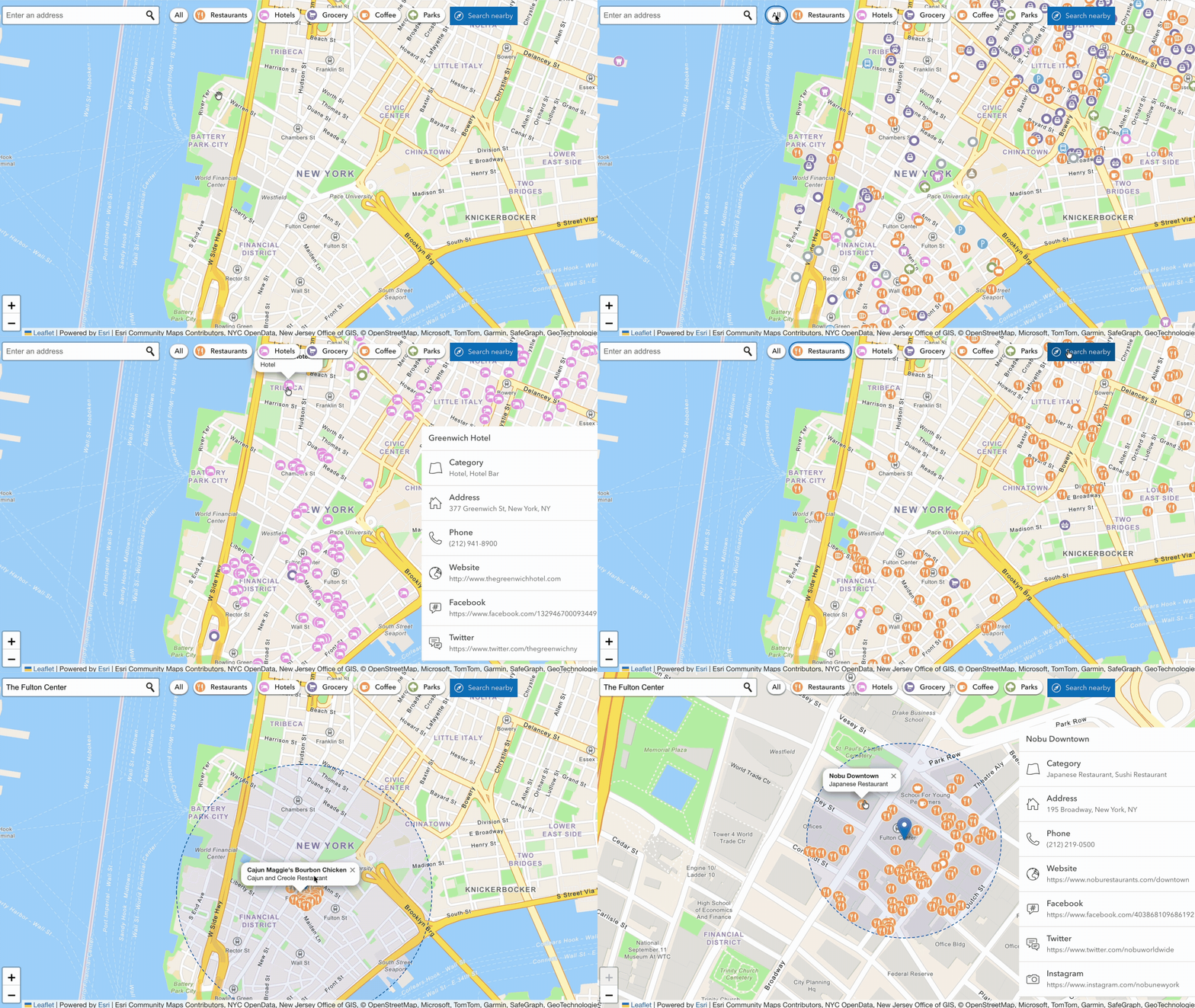
A places service helps answer “what’s nearby?” by revealing relevant locations such as schools, parks, stores, and transit, based on a given set of coordinates. The ArcGIS Places service gives you access to millions of points of interest (POI) across more than 1,000 categories. The categories cover everything from retail locations and public facilities to natural landmarks. The regularly updated, global data spans both the built environment and the natural landscape.
How would someone use a places service?
A real estate portal may want to bring an area to life for prospective buyers. Using a places service, they can show off what’s near any given listing. A neighborhood profile populates nearby schools, parks, grocery stores, and public transit options, pulled dynamically based on the listing’s coordinates.
What can you do with a places service?
The ArcGIS Places service can do the following:
- Search for places nearby. Return all the places within a given radius of a location, such as the geographic position of a device or a selected point on a map, with nearby search.
- Find places within a map extent. Search for and display places within the current map extent using bounding box search. Filter by category and text, as well as return attributes like name, location, place ID, and category data.
- Get details for a place. Retrieve rich attributes for a place including address, phone number, website, ratings, and cost information with place details.
Data Enrichment
What is a data enrichment service?
Data enrichment helps you understand the people and places associated with a location by adding demographic, behavioral, and environmental context to your data. With the ArcGIS GeoEnrichment service, you can easily integrate ready-to-use data sets that span over 170 countries and regions from Austria to Zimbabwe. You bring a point, a polygon, or a standard geography like a zip code, and the service returns detailed facts about the people and places within it.
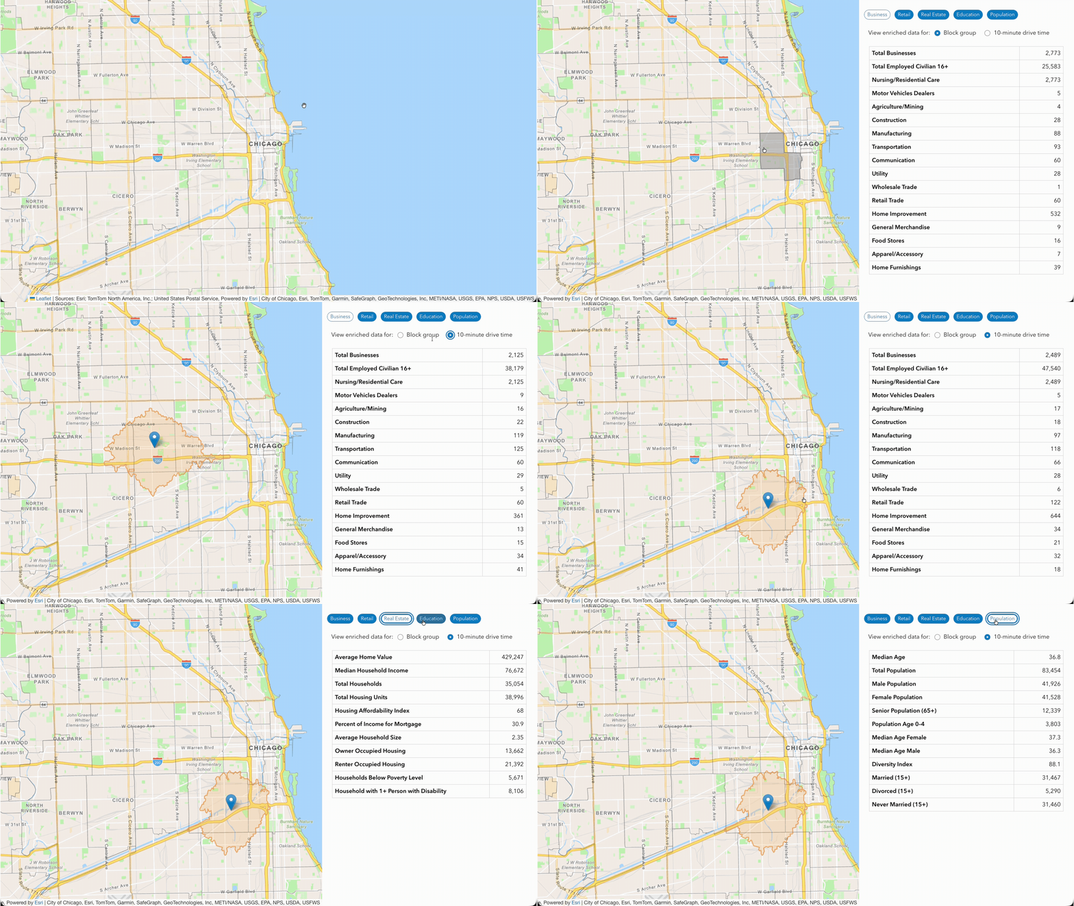
How would someone use a data enrichment service?
A Customer Relationship Management (CRM) software company might leverage data enrichment to provide end users with a greater understanding of a region. Demographics such as age, household size, education, and more as well as behavioral data like consumer spending can help a sales representative assess a prospect’s needs.
What can you do with a data enrichment service?
The ArcGIS GeoEnrichment service allows you to do the following:
- Discover global and local data. Find a global and local portfolio of rich authoritative datasets to meet your data enrichment needs with global data search and local data search. Query information about people, places, and businesses with areas of interest.
- Enrich custom geographies. Retrieve data for not only typical areas, such as a zip code or a county, but custom geographies like a sales territory with custom study areas.
- Generate actionable information. Create shareable reports, infographics, and authoritative data tables that can be used in applications, analysis, and visualizations with reports.
Elevation
What is an elevation service?
An elevation service provides height data for developers to integrate in their solutions for additional context about the terrain. The ArcGIS Elevation service has reliable, accurate data for any point on Earth. Whether that’s above ground, below ground, or below sea level. The Elevation service returns both ellipsoidal height (geometric distance above the reference ellipsoid) and orthometric height (height above mean sea level).
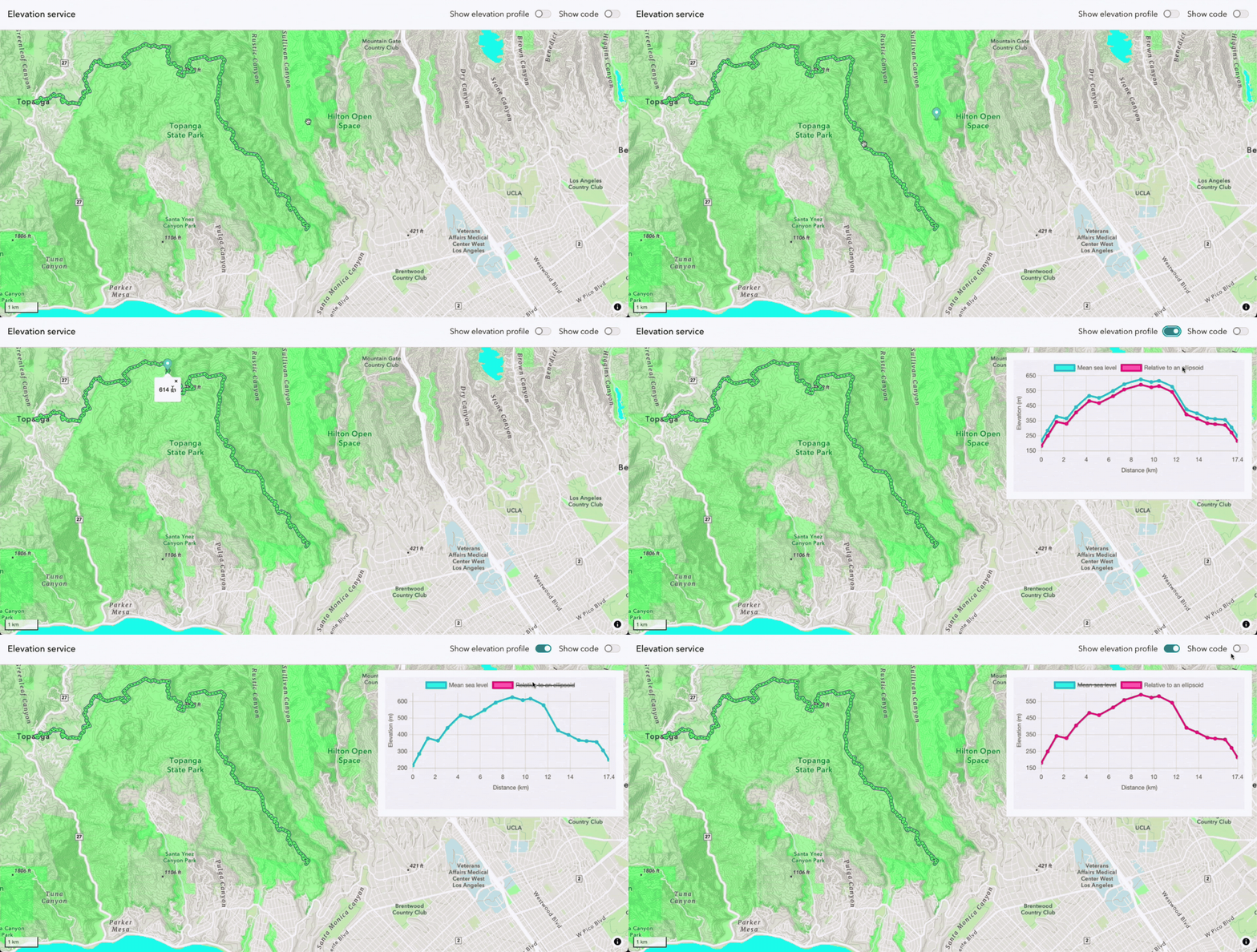
How would someone use an elevation service?
An adventure app for hiking could leverage elevation to let users plan trails with confidence. Using an elevation service, the app could show exactly what terrain looks like before a hiker ever steps on the path. Whether they are interested in the overall elevation gain or a specific point on the map, this information could help users assess their abilities or train towards a goal.
What can you do with an elevation service?
The ArcGIS Elevation service can do the following:
- Retrieve elevation values for a single point. Return the height above ground level or mean sea level for one location with point elevation.
- Retrieve elevation values for multiple points. Get elevations for multiple points in a single request with multiple point elevations, suitable for path profiling and bulk terrain analysis.
Getting Started
Location is a meaningful part of today’s world. Easily integrate the location services that are the most relevant to your solution through a convenient API key. Then add others as your application evolves.
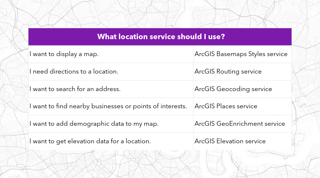
Ready to try ArcGIS Location Platform? Create your free account today!
Interested in staying up to date? Sign up for the Esri Developer Newsletter and follow Esri Developers on LinkedIn to get the latest.


Commenting is not enabled for this article.