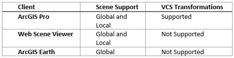
The ArcGIS Platform has many applications that support vertical coordinate systems. ArcGIS Pro is a powerful rich client that supports vertical coordinate systems (VCS) in both global and local scenes. Thin clients such as ArcGIS Earth and the Web Scene Viewer also support vertical coordinate systems. This blog will focus on support of global scenes across the platform. If you would like to check out the support for local scenes click here and for an overview on Vertical Coordinate Systems click here.
VCS Quick Overview
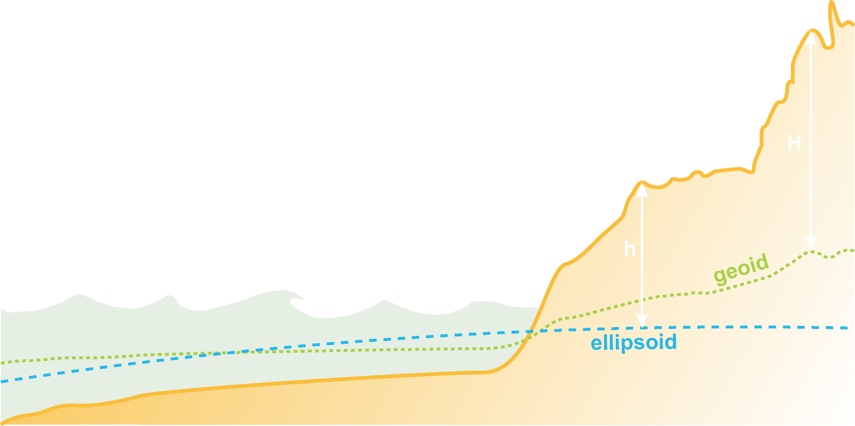
Before discussing why we need a VCS let’s talk about what a VCS is. A VCS defines the origin for height or depth values. A VCS is composed of the following components:
The key question we need to ask is why do we need a vertical coordinate system in the first place? The answers are similar as to why you would need a horizontal coordinate system (HCS). You need to be able to accurately locate real world features in your scene. This is especially important if you will edit the data, create new data, or perform analysis. GIS users know full well how frustrating it can be to come across undefined data or incorrectly defined data so it is essential not only to have the correct HCS but a VCS as well
Some additional questions you need to ask are what units should I be using and am I modelling phenomena with positive heights above a surface or positive depths below a surface? Also, are these phenomena influenced by gravity and atmospheric forces that require a gravity-related VCS or are the vertical values relative to an ellipsoidal surface.
Adding Data
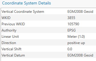
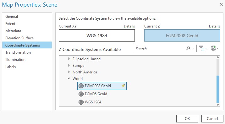
Currently, in ArcGIS Pro, a Global scene will have a horizontal coordinate system of WGS 1984. By default, no vertical coordinate system is defined. As a user, you have the option to define an ellipsoidal vertical coordinate system or the EGM2008/EGM1996 gravity-related vertical coordinate system. When you use an ellipsoidal vertical coordinate system, you must ensure that it matches the geographic coordinate system. For example, if z-value height is defined in NAD 1983, the geographic coordinate system must be defined in NAD 1983 also, not WGS 1984.
Sharing Data
Layers in your global scene are particularly useful when sharing across the platform to ArcGIS Earth or a portal. In addition to scene services, feature services, elevation services and image services support VCS.
When creating a scene layer keep in mind the following scenarios:
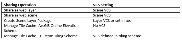
- The share as web layer and share as web scene workflow gathers the HCS/VCS information from the ArcGIS Pro scene properties
- The Create Scene Layer Package Tool gathers the HCS/VCS information from the layer properties. These settings can also be manually set in the tool.
The same rule applies when sharing a feature layer to ArcGIS Online. If performing the share as web layer or web scene workflow, the HCS/VCS information are taken from the scene properties.
To create an elevation service for ArcGIS Online, start off with the Manage Tile Cache Tool with LERC compression. This will create a tile cache that is set to use an horizontal coordinate system of Web Mercator Auxiliary Sphere with no vertical coordinate system. To utilize your own spatial reference and tiling scheme consider using the Generate Tile Cache Tiling Scheme tool with LERC tile format. Once this is exported to a Tile Package and published to ArcGIS Online, it can be added to a local or global scene. If you are sharing directly to portal then you can bypass these two tools and perform the share as web layer workflow to share directly as an elevation layer.
Web Scene Viewer
Once your data has been shared as a scene layer, feature layer, or image layer to Portal or ArcGIS Online you are able to display it in the Scene Viewer. The Scene Viewer does not support vertical transformations so all data will need to be in the appropriate vertical coordinate system for a global scene, which can be WGS 1984 or EGM2008/EGM96. Additionally, units of the HCS and VCS will need to be the same so everything will need to be in meters. If you are working with cached services (Scene Layers, Vector Tile Layers, Tile Layers, Elevation Layers) you will need to ensure everything is in the same coordinate system as well as same tiling scheme.
ArcGIS Earth
As a thin client, ArcGIS Earth currently supports a global scene only. What this means to you is that only WGS 1984 or WGS 1984 Web Mercator Auxiliary Sphere are supported for horizontal coordinate systems. It is not currently possible (Version 1.6.1) to set a vertical coordinate system. Datasets that have vertical coordinate systems can still be displayed in ArcGIS Earth. Cached data such as tile layers, scene layers, and image layers will need to adhere to the same coordinate system and tiling scheme in order to display in ArcGIS Earth.
Use cases
Note: The following use cases are examples only and are not professional recommendations on how data should be set up.
GPS Stations
Project Requirements
![]()
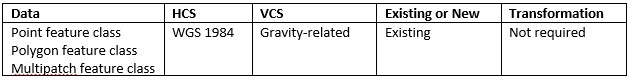
In this scenario, a GIS Analyst has a global set of GPS stations that are in the ITRF 2008 HCS/VCS. ITRF is frequently used for earth-based research but the GIS analyst would like to share this data out to the ArcGIS Platform for the public to view it. To achieve this outcome, the analyst will need to add the data to a global scene in ArcGIS Pro and apply a transformation. Since the VCS transformation is an ellipsoid to ellipsoid transformation a standard equation-based geographic transformation will apply for this case. After performing the transformation in the global scene properties, the data is ready to share. To complete the workflow, the analyst will use the share a web scene workflow. Once shared, the data is ready to be viewed in the Scene Viewer or in ArcGIS Earth.
![]()
Earthquake Points
Project Requirements

A GIS Analyst would like to map locations of earthquakes across the planet. They would like to visualize the points below the surface at the correct depth where the earthquakes occurred as well as edit the points if necessary when the epicenter is updated. They have decided to use WGS 1984 as the horizontal coordinate system and EGM2008 depth as the vertical coordinate system. They have the data in tabular format so all that needs to be done is to create a new point feature class with the proper HCS/VCS. Since earthquakes originate beneath the surface of the Earth, the EGM 2008 depth is necessary. Z values will represent positive down values in units of meters. Once they have loaded the data into the 3D-enabled dataset they will be able to visualize the earthquakes at the accurate depth and edit as necessary.
Weather (temperature, wind speed, pressure)
Project Requirements
Modeling global weather phenomena is a key use case for using vertical coordinate systems. Weather variables such as temperature, wind speed, and pressure are measured at certain heights and maintaining the accuracy of these measurements over time is key. A GIS Analyst recently received new weather observations and needs to add them to an existing feature class. For this use case, a global gravity-related VCS is necessary. EGM 2008 will be used for this specific data. Z values represent positive up and will be measured in units of meters. Having a vertical coordinate system ensures the data is accurately added to the dataset at the proper height and can then be further used for analysis and visualization.


Article Discussion: