Mapping

Announcing the new Ocean basemap

By Aileen Buckley, Mapping Center Lead
BCS award - thumbnail

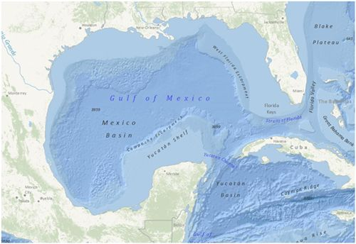
The Ocean Basemap (Ocean_Basemap) map service was published recently on ArcGIS Online (services.arcgisonline.com, server.arcgisonline.com). This global map shows the sea floor of the oceans, along with both surface feature names and subsurface feature names. The Ocean Basemap is designed for use by GIS professionals interested in bathymetry, marine science and conservation, and ocean mapping.


Currently the Ocean Basemap service is available globally down to 1:1,000,000. The smallest scales use a global bathymetry dataset from the General Bathymetric Chart of the Oceans GEBCO_08 grid. At 1:1,000,000 scale, the bathymetric data in U.S. waters is from the National Oceanic and Atmospheric Adminstration (NOAA).

For information on how to use the Ocean Basemap, see Using your own basemaps (and projection) with the ArcGIS.com map viewer.

If you have questions or feedback, please post them in the ArcGIS Online forum.

About the author

Dr. Aileen Buckley has been making maps since she was an undergraduate student. She has a Bachelors in Geography and Spanish from Valparaiso University, a Masters in Geography from Indiana University, and a Ph.D. in Geography from Oregon State University. She is a senior product engineer on the Living Atlas team, and her work focuses on determining and sharing best practices for mapping and analysis with modern GIS. She publishes and presents world-wide on many aspects of mapping and GIS. She is a co-author of Map Use: Reading, Analysis, Interpretation, and she is a co-editor for the Atlas of Oregon. Aileen is a former president of CaGIS (the U.S. cartographic association) and is actively involved with the International Cartographic Association in which she is the lead delegate for the United States.

Connect:
0 Comments
Inline Feedbacks
View all comments

Next Article

Join Hacktoberfest 2023: Celebrate Open Source with Us!

Read this article