With the June update to ArcGIS Online, there are some big updates such as the enhanced interface and experience with item pages, new smart mapping styles, and added features for the scene viewer. The same goes with configurable apps. Rolling out in this release will be four new apps, impactful updates to two others, and an improved experience for choosing which web map, web scene, or group your app will consume.
New Basic Viewer
A new version of the Basic Viewer is now available that has better support for accessibility in reference to the objectives in Section 508. All previous functionality and configurable parameters are still present, but there are updates to the UI look and feel. Included in the accessibility updates are options for alternative text and better keyboard navigation support.
New Time Aware
The Time Aware app takes advantage of time enabled data within a web map. New with this release is an updated version of this experience but with added functionality to better control the date/time formatting, as well as managing and showing time data that is updated frequently or live. Date and time formatting has its own tab in the configuration panel where control of the time slider’s display of the date range can be managed. Also, a custom date format can be declared if these options do not provide enough control. Another new tab contains the parameters for handling time enabled data that is updated frequently. This gives the option to look at only features that were created within a specified amount of time compared to the present. For example, all features created in the last 4 hours. The range’s end time in this case is set as the run time of the app.
Introducing: Story Map Cascade (beta) and Story Map Crowdsource (beta)
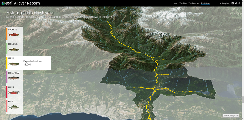
Our Story Maps team has rolled out two new and exciting apps that are in beta. The Story Map Cascade (beta) app is similar to the current Story Map Journal app, in that it is designed to tell a story through various forms of content such as maps, 3D scenes, images, videos, and more. What Cascade introduces is a full-screen scrolling experience that blends narrative text, content, and media using transition effects to produce a seamless and consistent story for the audience that is easy to navigate. Maps and 3D scenes included in Cascade can be static, automated in a specific sequence, or interactive for the audience to explore. To see this beta app in action, check out The Uprooted and A River Reborn, which are two great examples that are perfect for the Story Map Cascade’s purpose.
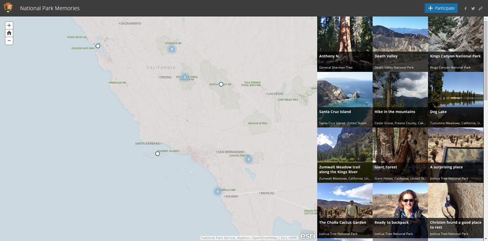
Also new to the Story Maps collection is the Story Map Crowdsource (beta) app. This app is designed to create a crowd sourcing experience that allows anyone to contribute their photos and comments to a specified topic. Users can log in to the app using their social media account, ArcGIS account, or use a guest option. As an app creator, you can choose to screen the submissions using a review and approval process that is managed through the builder, or choose to have submissions appear on the map automatically.
Updates to 3D Data Visualization
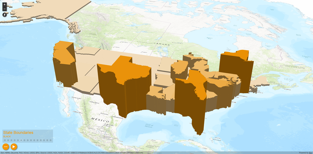
New visualization options are available to app creators of 3D Data Visualization. When this app was introduced in the last release, only point extrusion was available. Now, we have included polygon extrusion and point pulse. Polygon extrusion works in the same way as point extrusion, but extrudes entire polygon boundary areas. Point pulse visualizes point data as pulsing circles that animate outward across the map.
Updates to Crowdsource Manager
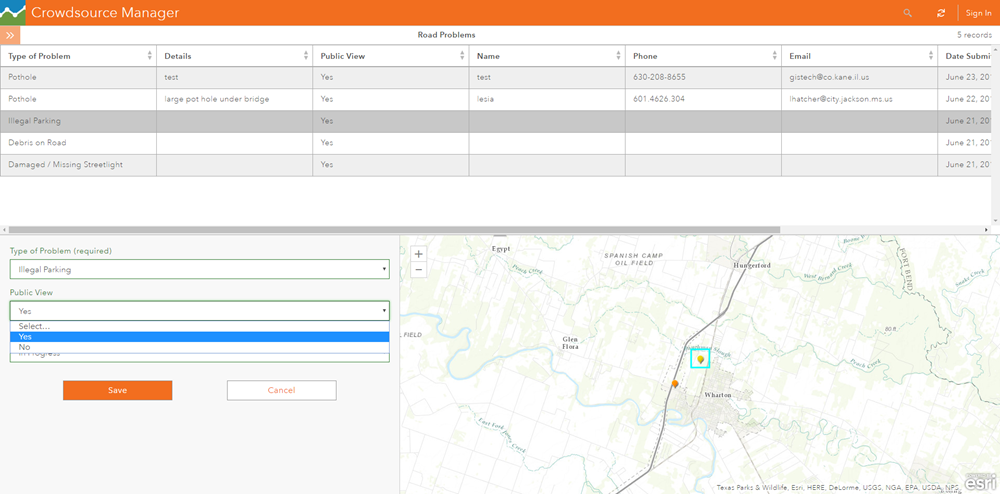
The Crowdsource Manager app introduces several key updates. There is now support for non-editable layers, allowing them to be used as reference layers along with editable layers. Editing of report attributes has been moved out of the table and into a form style editing experience. This is also true for related records that are associated with each report. Additionally, it is now possible to update attributes of multiple records at a time by using CTRL + left click to select multiple rows from the table or features from the map. Media that is referenced in popups or included as attachments can now be viewed in a larger, gallery style format rather than just thumbnails.
Creating Apps from Item Pages
In the past, a hosted app could be created from the set of configurable apps in three ways: the map viewer, the My Content page, or item page of the source app from the gallery. New with this release and in conjunction with the overall enhancements to the item pages, there is now a button within the item pages of web maps and web scenes that allows app creation called “Create Web App”. This provides the same experience as the other three methods by presenting a selection gallery to choose a desired configurable app and then being directed to the configuration panel of that app to get started. Since the app creation process is initialized from the item page of a specific web map or web scene, that map or scene is already set as the chosen target for the app. At anytime, a different web map, web scene, or group can be chosen by using the enhanced map/scene browser.
Enhanced Browse Experience for Web Maps and Web Scenes
The browse experience has been enhanced when choosing a web map, web scene, or group within the configuration panel of an app. The UI has been updated to reflect that of the app search window found in other parts of ArcGIS Online. Preset filters to browse content are present and include searching all public content, only content owned by you, or all content shared with your organization. A search box is offered allowing items to be found via search terms that cover both titles and tags. For particular apps that allow the selection of multiple maps or scenes, the experience has been enhanced to make it easier to select and deselect various items within the browse window: left-click to select, left-click again to deselect.


Article Discussion: