Earth observation (EO) data is becoming increasingly important for monitoring and assessing the world we live in as typical data collection methods can often be costly and inaccessible. EO data is obtained remotely from satellites orbiting our home planet, and can be used to improve decision-making across a wide array of sectors. Agriculture is one of the key industries that benefits most from EO data.
The frequent, repeatable, and transparent information provided by satellites can inform agricultural assessments and identify potential food security impacts. With the help of EO-based information (such as crop and soil health), experts can better forecast potential food shortages. With this information available early on, decision makers can then ensure humanitarian aid reaches the populations most affected by environmental and climate shocks.
Satellite information can be tremendously beneficial for our communities and livelihoods, and putting this information into the hands of farmers, policy makers, and economists can have profound impacts on global food security.
One of the groups leading the charge is NASA Harvest, NASA’s global food security and agriculture program, dedicated to advancing the uptake of satellite Earth observations by public and private organizations to benefit food security, agriculture, and human and environmental resiliency in the US and worldwide. A critical step to increasing the use of EO data is to first increase end users’ trust in these products. To build this trust, satellite-based products and models need to be validated and their accuracy tested. A key piece of this effort is the collection of ground truth data to validate the satellite-based products. However, there is currently a lack of necessary ground data, and most notably across less-developed countries.
To address this data gap, NASA Harvest, in partnership with the United Nations Food and Agriculture Organization (UN FAO) Global Information and Early Warning Systems Network, tested methods for the collection of critical ground data for the development of cropland and croptype maps across pilot countries in sub-Saharan Africa. They used ArcGIS Survey123 to pilot an easier and more accurate way of obtaining ground truth data sets, covering cropland and croptype mapping needs and contributing to yield forecast estimation for complex small holder agricultural lands. With more ground data available, NASA Harvest can now validate its EO-based products and models with the aim of providing more reliable early warning systems to support food security decisions.
Small land holds, big data gaps
Satellite imagery is incredibly accurate when mapping larger agricultural systems with clear field boundaries and cropping regimes. However, even at high resolution, satellite imagery lacks the detail required to map the world’s small holder agricultural systems. In many countries, small holder agricultural fields – as the name suggests – are small (>.5 ha), and therefore subject to mixed cropping with multiple crops planted together in the same season. In some cases, these farms can have incredibly complex field boundaries that are hard to identify and require someone to physically walk the field boundary with the farmer present to accurately map it.
The mapping of field boundaries – commonly called field boundary delineation – not only allows for a better understanding of cropped areas, but also provides more accurate data to train machine learning models to predict crop yields and crop impacts should disaster strike.
And as you can imagine, crop conditions can change quickly throughout a season hit by flooding, drought, and pests.
“Satellite data is the first and easiest tool to monitor changes to agriculture at scale and identify where impacted areas may be, but ground data to verify and validate these satellite products is lacking,” explains Christina Justice, principal faculty specialist at the University of Maryland Geographical Sciences Department and the Food Security and Early Warning Co-Lead for NASA Harvest. “NASA Harvest recognizes the power of satellite data to help inform food security decisions and where humanitarian aid is needed most.”
Collecting accurate ground truth data has its challenges.
It is no secret that ground data collection can be costly (travel to farms, data storage, computing expenses, etc.) in addition to a typical lack of internet connection when traversing rural fields. Data collection processes should be simple, easily understood by users, mobile, and available offline – quite a distance away from the paper forms that have been used in the past for rapid crop assessments.
Even with a move to digital forms, the data collected on the historical open-source forms are contained to purpose-built dashboards limiting who in the Ministry of Agriculture can access them. Though freely available, the open-source solution required extensive training limiting the software knowledge to a few specialists who could use and maintain the system.
To improve the national assessment’s data quality, the consortium sought to standardize and modernize this data collection while encouraging in-country field staff to collect crop assessments regularly – even without a reliable cell signal.
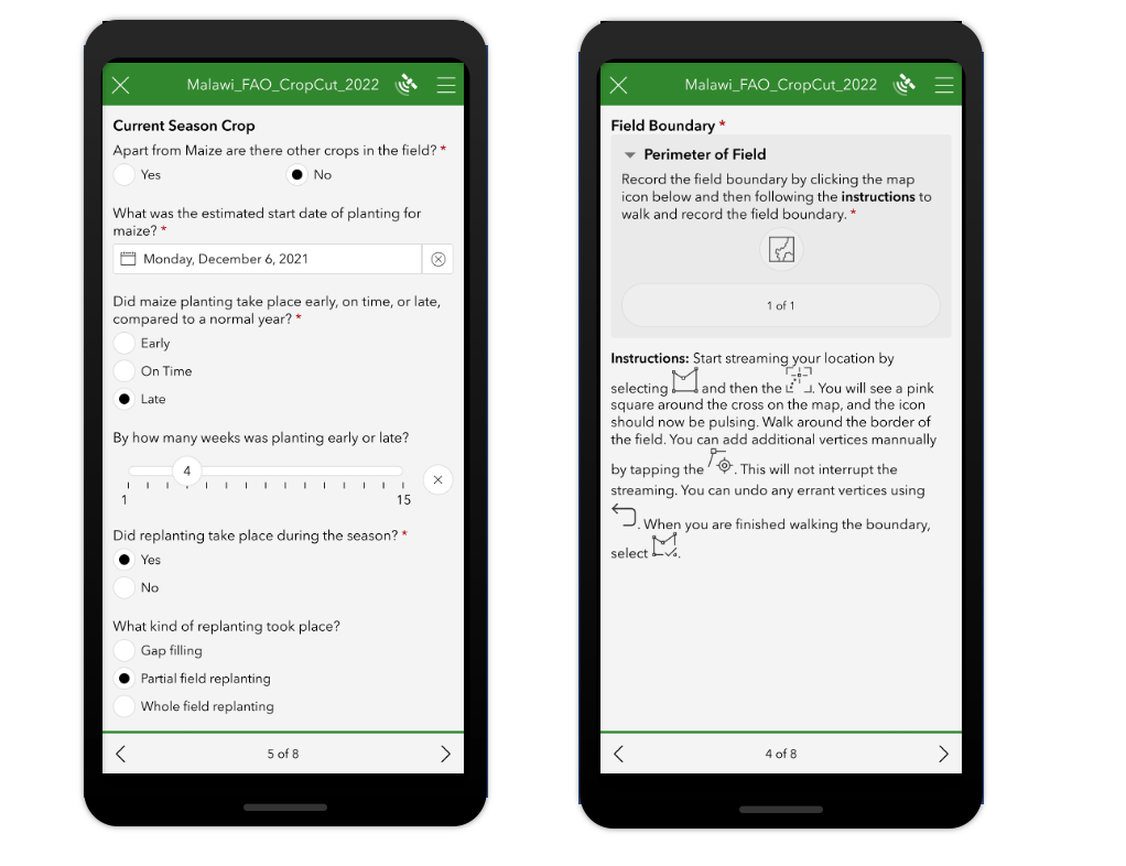
FAO in partnership with NASA Harvest are working toward a more ideal digital format with the use of Esri’s ArcGIS Survey123 application. Implementing Survey123 (dubbed “HarvestNow” by NASA Harvest developers), the enumerators can easily collect data offline on tablets as they walk through fields, thus streamlining data collection and analysis. As an added benefit, the resulting data and assessments are exponentially more accessible.
Time to modernize
With a vision to digitize ground data collection, NASA Harvest prioritized geo-locating crop types in Malawi and running a rapid crop assessment campaign in season. This pilot project tested the hypothesis that local experts familiar with the culture, land and language, could be equipped with tablets or phones to collect data about the agricultural lands and help inform national assessments. If it worked, it could then be rolled out on a larger scale and used by the Ministry to support their regular crop assessments.
As NASA Harvest wanted to invest in a scalable solution that could allow for consistent data collection globally, the organization required technology that was both easy to use and could be effectively transferred to other regions.
The solution: Survey123
After hearing about ArcGIS Survey123 from a colleague, Justice saw the benefits of this tool and its capabilities on the backend. Not only did Survey123 allow her to complete tests on a laptop away from the office, she also found it incredibly easy to use.
The team was familiar with Survey123 from other projects and was impressed by the options available to them out of the box as it allowed developers to prioritize other projects instead of building capabilities for a digital form. As Survey123 is included in ArcGIS Online, they could also make public-facing dashboards to show the Ministry of Agriculture the results nearly in real-time.
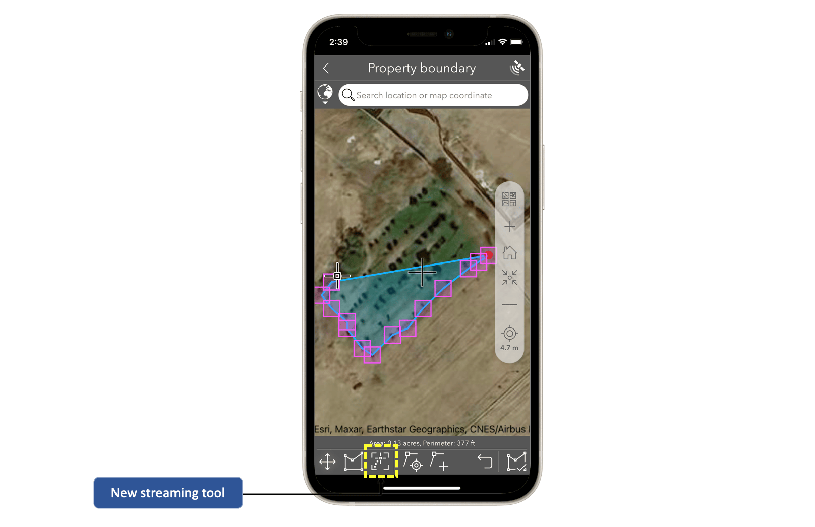
However, Survey123 lacked a crucial feature: A streaming service. Survey123’s annotation tools worked well for clear, long boundaries that could be identified and drawn on a map, but NASA Harvest required something that would accurately collect both the size and shape of a field boundary as a polygon. This would help the organization calculate the area of each holding with limited user intervention as the data was collected by FAO’s field boundary representatives who walked the fields with farmers.
Not one to be discouraged, Justice approached Ismael Chivite, product manager, ArcGIS Survey123, to understand if a streaming field boundary collection feature could be created.
“Thankfully, the Survey123 development team saw the real potential for this streaming feature in application to both this and other user needs and took on the project,” explained Justice. “Working collaboratively, within a month, we had a beta feature ready to test in the field campaign.”
Improved form, improved data
As the technical partner on the project, NASA Harvest developed the survey used in the field for both the crop assessment and critical yield data. When ready for use, they simply used Survey123 Connect to publish it to ArcGIS, allowing field agents ready access to begin collecting data.
“When users got the hang of it, they found it easy and used it quickly,” said Justice. “The Survey123 team developed it better than we could have ever imagined with the ability to determine the level of accuracy and user-friendly features for easy data collection.”
The solution included a basemap which improved the experience for the enumerators. After trial and error, the teams realized that they could download the local basemaps to the Survey123 field app for use offline giving them the ability to collect information across the entire area without using cellular data.
“With the basemaps, our teams were also able to see the local roads and terrain and visualize the results of their work in real-time,” explained Justice. “Having the field boundaries visible on the screen was an exciting new feature that allowed the teams to share with the farmer and communicate both the field size and shape.”
With its offline data collection capabilities, Survey123 allowed the team to complete their work anywhere without of the need of cellular data, and then simply connect to Wi-Fi at the end of the day when they were back at the office to send their forms. This limited the cost to the team and provided the flexibility they required.
A successful pilot
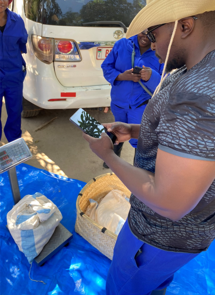
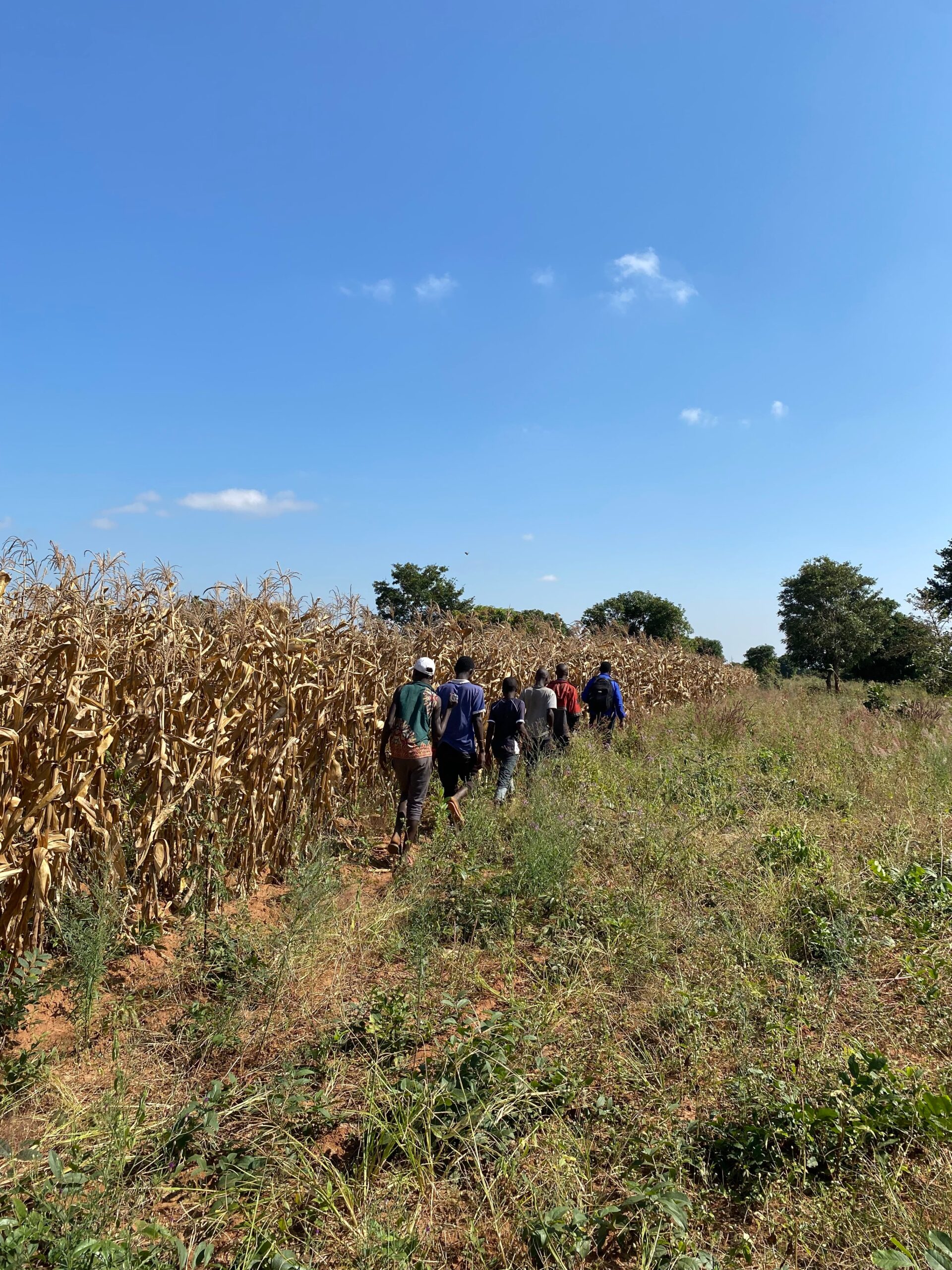
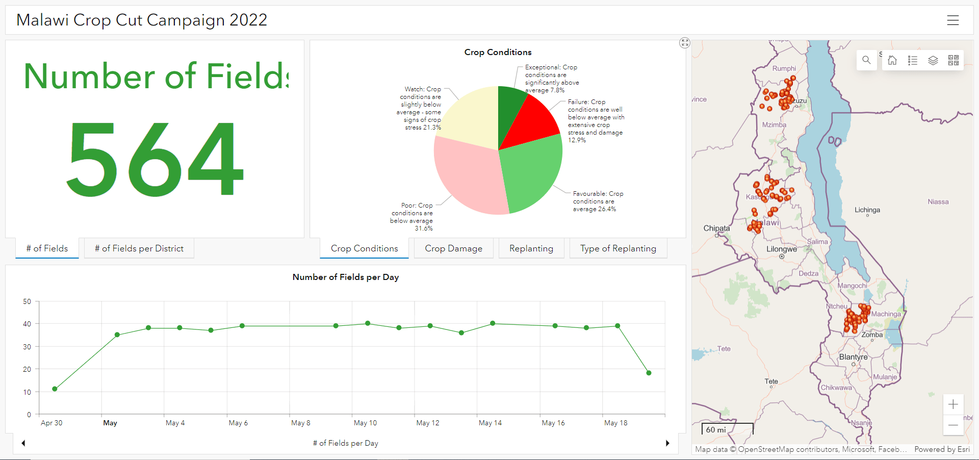
Throughout the 30-day campaign, 20 field agents equipped with tablets visited up to four fields per day in teams of two across three districts resulting in over 560 visits. Along with collecting the field boundaries, they geo-located crop types, yield data, and held farmer interviews to understand more about the cropping season and impacts from delayed rains, pest, drought, flood, enhancing the data.
At the end of each day, they uploaded their data and everyone could monitor the progress of the campaign in an ArcGIS Dashboard. The Dashboard helped the team monitor the campaign progress providing analysis of the data as it came in. It allowed them to keep track of the information collected and campaign leads which helped to spatially understand the impact of pests, drought and even floods on farmers’ fields.
By using Survey123, Justice confirmed their data collection process is much more streamlined. She is also grateful to have baseline surveys NASA Harvest can build off of as it expands its data collection in the future.
“To truly develop an accurate early warning system based on EO, there is a critical need to collect ground truth data that can help inform our models and products,” said Justice. “There is no substitute for this for small land holders, and there is big potential for the tool to be used and applied to regular operational activities of multiple ministries across the world.”
After the success of the pilot in Malawi, NASA Harvest expects to expand this data collection method in other areas. Until then, in post-analysis they can compare the yield estimates to the actual yields collected with Survey123 to build out forecasting models to ensure those who need aid receive it.
About NASA Harvest
NASA Harvest is NASA’s Global Food Security and Agriculture Program within the NASA Applied Sciences Program, operating as a public good consortium led by researchers at the University of Maryland. The consortium is comprised of over 50 partners around the world and across the agricultural sector, from public industry, to humanitarian organizations, to government and academic institutions. Since 2017, NASA Harvest has been committed to strengthening Earth’s food system resilience to climate shocks by enabling the uptake of valuable Earth observation applications. With a focus on food security and early warning, agricultural yield forecasting and land use mapping, the consortium continually improves humanitarian and agency response to food system shocks. EO data applications are developed alongside stakeholders to ensure information and aid reaches the most affected populations by targeting where relief is needed most. Learn more at nasaharvest.org.

Article Discussion: