ArcGIS Urban is the ultimate multitool for planners, offering you the ability to seamlessly sketch and analyze the impacts of proposed development or zoning changes, while providing the convenience and productivity of a user-friendly web-based application.
We invite you to discover ArcGIS Urban at this year’s Esri User Conference in San Diego, CA from July 11-14, 2023 (haven’t registered yet? There’s still time!). With so many fascinating sessions to choose from, here are our recommended sessions for discovering the potential of ArcGIS Urban with essentials for getting started and practical insights for real-world applications.

Tuesday July 11
- Geodesign and Digital Twins: The Road Ahead (10:00 AM PDT)
- Visualizing Growth and Development to Make Informed Decisions (1:00 PM PDT)
Wednesday July 12
- ArcGIS Urban: An Introduction and What’s New (1:00 PM PDT)
- ArcGIS Urban: Implementing VR for Immersive Collaborative Urban Planning (2:30 PM PDT)
Thursday July 13
- ArcGIS Urban: Implementing Urban Planning Workflows (2:30 PM PDT)
All UC 2023 session times and dates are subject to change.

Geodesign and Digital Twins: The Road Ahead
What are “digital twins”? See how digital twins are revolutionizing the way we visualize and design our cities and discover ways to create your own with ArcGIS Urban, ArcGIS City Engine, and ArcGIS GeoBIM.
Add to your schedule: Tuesday, Jul 11 | 10:00 AM – 11:00 AM PDT
🌎 If you’re interested in digital twins, check out Planning for the Future and Your Guide to Empower Resident Collaboration with GIS.
ArcGIS Urban: Implementing VR for Immersive Collaborative Urban Planning
Curious how a VR headset could help you foster deeper and more meaningful stakeholder engagement? Learn how game engine technology can elevate your next planning project with interactive, visually compelling experiences built with ArcGIS Urban.
Add it to your schedule: Wednesday, Jul 12 | 2:30 PM – 3:15 PM PDT
🌎 To try ArcGIS Urban on VR for yourself, come to the Community Development Area (see map below). We’ll have headsets available for a first-hand perspective of what VR for community engagement looks like.

ArcGIS Urban: An Introduction and What’s New
Wrap up your Tuesday with an introductory session on ArcGIS Urban and learn how to:
- Lower the cost of recurring zoning reform and plan updates.
- Provide project transparency.
- Transition from analog processes to digital ones.
- Leverage 3D data to create alternatives to static maps and presentations.
- Foster collaboration across stakeholders and enhance community representation.
If you can’t make the Tuesday afternoon session, we’re offering it again on Wednesday afternoon at 1:00 PM PDT. You can, of course, always stop by the Community Development Area to talk one-on-one with our team about ArcGIS Urban and how it can support your next planning project!
Add it to your schedule: Tuesday, July 11 | 4:00 PM – 5:00 PM PDT and Wednesday, July 12 | 1:00 PM – 2:00 PM PDT (Available Online)
? If you’re interested in taking your knowledge of ArcGIS Urban to the next level, be sure to attend ArcGIS Urban: Implementing Urban Planning Workflows and ArcGIS CityEngine: An Introduction and What’s New to learn about their integration.
ArcGIS CityEngine: An Introduction and What’s New
If ArcGIS Urban is the ultimate multitool for planners, then ArcGIS CityEngine is an advanced multitool for urban designers. Learn best practices for leveraging ArcGIS CityEngine by preparing quality data and understanding its interplay with ArcGIS Urban.
Add it to your schedule: Wednesday, Jul 12 | 10:00 AM – 11:00 AM PDT and Thursday, Jul 13 | 4:00 PM – 5:00 PM PDT
? Check out the ArcGIS CityEngine agenda for more related sessions.
ArcGIS GeoPlanner: An Introduction and What’s New
Looking for the latest geodesign-based workflows for natural systems and landscape planning? ArcGIS GeoPlanner is a geodesign and scenario planning tool that balances design intent and environmental constraints through spatial analysis and data-visualizations. See how it can assist you in making more informed environmental planning decisions.
Add it to your schedule: Tuesday, Jul 11 | 2:30 PM – 3:30 PM PDT and Wednesday, Jul 12 | 4:00 PM – 5:00 PM PDT
ArcGIS Solutions: Building 3D Basemaps
With ArcGIS Urban, you have the option to visualize your town or city using pre-existing 3D buildings and trees, or you can import your own 3D basemap to leverage your existing data. If you’re curious about creating your own 3D basemaps for ArcGIS Urban, attend this session to see how you can use ArcGIS Solutions to get started.
Add it to your schedule: Tuesday, Jul 11 | 2:30 PM – 3:15 PM PDT

ArcGIS Urban: Implementing Urban Planning Workflows
Discover the potential of ArcGIS Urban and ArcGIS GeoPlanner as they replicate scenarios for a wide range of planning-related projects, including zoning reform, land-use, and development projects. Learn how to use these products independently and in harmony to evaluate ideas, concepts, and proposals with data-backed insights and guidance for effective planning.
Add it to your schedule: Wednesday, Jul 12 | 11:30am – 12:15pm PDT and Thursday, Jul 13 | 2:30pm – 3:15pm PDT
ArcGIS CityEngine: Procedural 3D Content with ArcGIS
ArcGIS CityEngine is an advanced modeling software that can be used in conjunction with other tools to enhance 3D workflows. This session will provide an overview of how to leverage the power of Twinmotion, Game Engines and NVIDIA Omniverse, and how to take advantage of CityEngine Plugins as well as PyPRT, a Python binding for CityEngine Procedural Runtime.
Add it to your schedule: Thursday, Jul 13 | 1:00 PM – 1:45 PM PDT
5 Tips to Address Our World’s Planning Challenges
Join industry experts as they discuss the evolving landscape of urban planning, exploring current challenges and how technology is shaping the profession.
Add it to your schedule: Tuesday, Jul 11 | 11:30 AM – 12:15 PM PDT

Planning and Economic Development SIG: Addressing Today’s Pressing Planning Challenges
Join the community development team as we discuss emerging trends and challenges the industry is facing. As the world shifts from crisis response to recovery, sustainable and equitable planning begins to dominate the conversation. We’ll discuss ongoing issues such as housing policy and zoning reform, economic development, and resiliency. Network with colleagues in the field to see the new GIS solutions that will help you keep pace as planning technology advances, address equity and civic inclusion, and match federal relief funding to your initiatives.
Add it to your schedule: Wednesday, Jul 12 | 11:30 AM – 12:30 PM PDT
Digital Twin SIG
Are you interested in Digital Twins? Attend this SIG to meet and engage with other users who are focused on deploying Digital Twins in their industry. Esri will have experts on site to help facilitate conversations and connect you with like-minded peers.
Add it to your schedule: Tuesday, Jul 11 | 11:30 AM – 12:30 PM PDT

Digital Twins for Urban Planning
Digital twins revolutionize urban planning by creating virtual city replicas for simulating scenarios, optimizing infrastructure designs, and enhancing decision-making processes. See how ArcGIS Urban, ArcGIS CityEngine and other Esri solutions are helping cities, like the City of Kelowana and San Diego, plan for a brighter future.
Your Guide to Empower Resident Collaboration with GIS
Add it to your schedule: Thursday, Jul 13 | 8:30 AM – 9:30 AM PDT
Planning for the Future
Add it your schedule: Thursday, Jul 13 | 10:00 AM – 11:00 AM PDT
Housing and Development
Discover how planners in Houston and Philadelphia are tackling the challenge of creating and preserving affordable housing in their respective cities.
Visualizing Affordable Housing Developments with a Geographic Approach
Add it to your schedule: Tuesday, July 11 | 10:00 AM – 11:00 AM PDT
Visualizing Growth and Development to Make Informed Decisions
Add it to your schedule: Tuesday, July 11 | 1:00 PM – 2:00 PM PDT
Stakeholder and Community Engagement
Successful urban planning initiatives are based on fostering stakeholder collaboration and community involvement. See how planning professionals in Ottawa, Hawaii, and San Diego are using GIS to empower resident collaboration and keep key stakeholders informed.
Your Guide to Empower Resident Collaboration with GIS
Add it to your schedule: Thursday, Jul 13 | 8:30 AM – 9:30 AM PDT
Streamlining Collaboration to Create Efficient Planning Workflows
Add it your schedule: Tuesday, Jul 11 | 2:30 PM – 3:30 PM PDT

Want to chat with us 1:1? Head to the Community Development Area, located conveniently at the heart of it all by the UC Info Desk. We’ll be there from 9:00 AM – 6:00 PM on Tuesday, July 11 to Wednesday, July 12 and 9:00 AM – 4:00 PM on Thursday, July 13. Have a question that can’t wait? Let us know in the comments or reach out to us at smartplanning@esri.com.

To access your own interactive version of this map on a desktop or mobile device, see the new UC Event Map. Use this map to generate turn-by-turn directions for navigating to one session location to the next and see your estimated arrival time. Along with the Detailed Agenda and My Schedule, this map is a helpful tool for planning your UC experience, from sessions to coffee stops. The map is also be available in the Esri Events App so that you can navigate on-the-go and at directory kiosks on site in the convention center. Learn more.
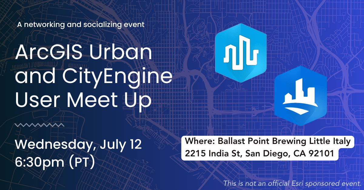
ArcGIS Urban and CityEngine User Meet Up
We’re hosting a gathering for our ArcGIS Urban and CityEngine customers on Wednesday, July 12 at 6:30 pm (PT) and would love to see you there. Hang out, meet the team, and get to know other industry professionals who are working with our products.
Details:
Wednesday, July 12 | 6:00pm
Ballast Point Brewing, Little Italy
2215 India St., San Diego 92101
No registration required. Simply stop by!

Article Discussion: