ArcGIS Urban makes 3D scenario modeling accessible to planners, allowing them to simulate different approaches to development before putting them into action.
Import plan boundaries
A plan in ArcGIS Urban is a means to simulate or validate different approaches to zoning and land use for a specific area within a city, town, or region. Plans can include information about space uses and building types, setbacks, and other important parameters to help you model where and how development could occur.

Creating a new plan is as simple as drawing the plan’s boundary. To make this even easier and consistent with the boundaries used in your city maps and documents, you can now import plan boundaries directly from your GIS department’s data repository.
Add and manage data more efficiently
Plans and other content in ArcGIS Urban are designed to be dynamic and adaptable to changing circumstances. You can now add and update data, for example to keep your plan’s data coordinated, with improved functionality to bring in data from existing services and spreadsheets.
Enhanced data filtering options
With the enhanced search and filter options, it is now simpler to locate the data you need to add to your plan from your GIS repository. Search for an item using its name, description, or URL, and then use the new filters such as owner, data type, and sharing level to narrow down your results.
Automated error scanning
Before data is added, it’s scanned for any potential errors that could affect the reliability of your modeling. With an improved data validation experience, you can quickly navigate to any errors that may have been caught during the import process.

Make necessary data edits with a direct link to the input service, then use the new “Refresh” button in ArcGIS Urban to revalidate and complete the import process.
Support for more symbology types
Let’s say that your city or town council recently approved a new zoning ordinance that introduces mixed-use development zones in certain areas. You can incorporate this new zoning overlay directly from your GIS repository using the import from layer symbology option.
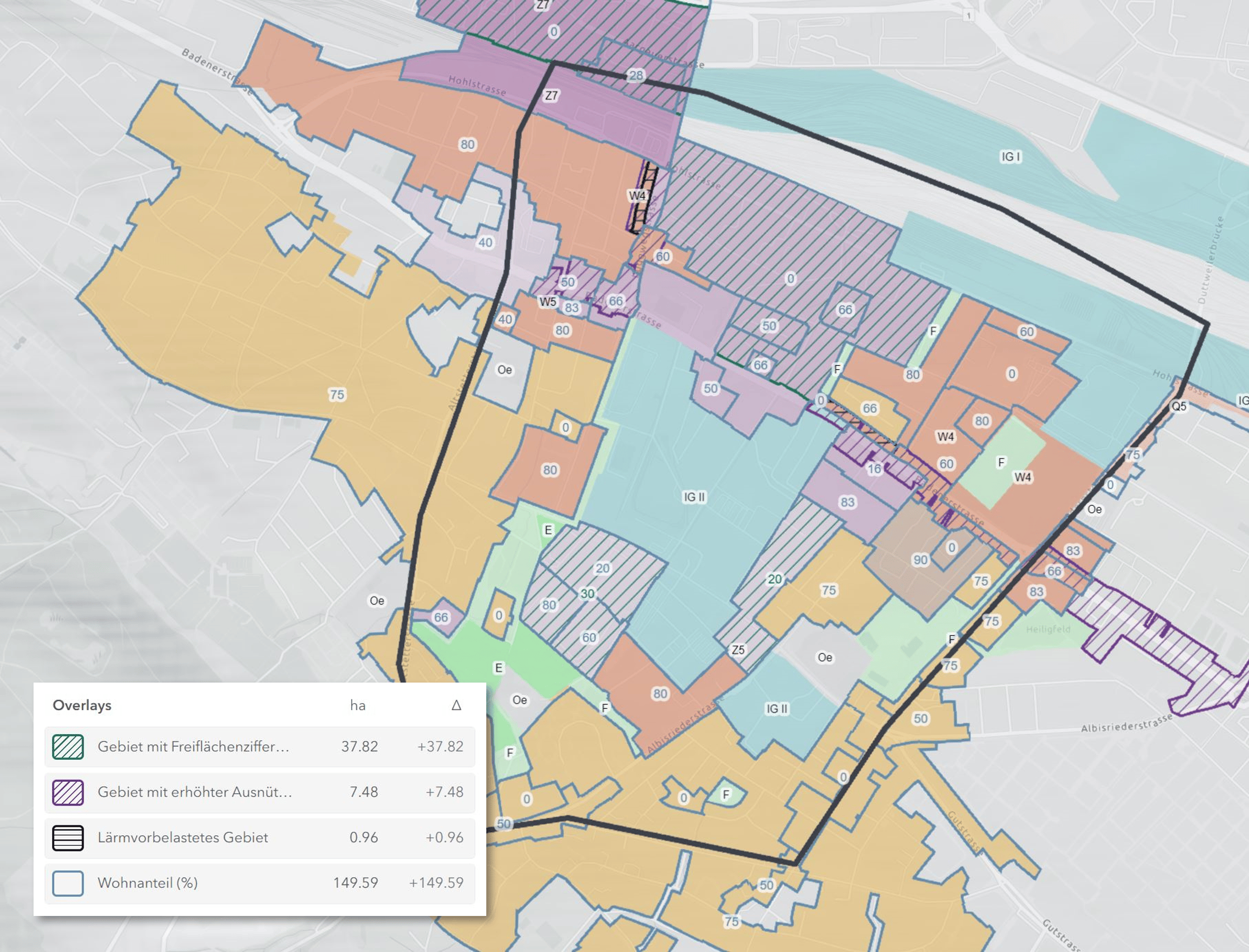
With added support for different pattern symbology, you can now import overlays and zones along with their symbology, including hatch patterns. This allows for a clear distinction from solid styles. This ensures that your overlays in ArcGIS Urban maintain a uniform visual appearance with other zoning maps and documents.
Redefine plan boundaries
If your original plan boundary changes, for example, if you need to incorporate a neighboring area, you can use the new edit boundary tool to adjust the boundaries of your plan for greater control over the shape and size of your plan area.

Copy parcels, spaces, and zones across scenarios
To include parcels in the expanded planning area, you can import them from the Urban model and use the copy and paste feature to apply newly added parcels, spaces, zones, and overlays across a plan’s multiple scenarios.
Duplicate and reuse building designs
If you have created a building and wish to reuse it again, you can easily duplicate it and relocate it to a different location within the same scenario. You can also copy the building’s corresponding parcel to paste the duplicate in a separate scenario.
Rather than starting from scratch each time a similar building is needed, this feature provides a level of flexibility and customization for creating different versions to compare changes in design and space uses. This can be particularly helpful for when planners need to present multiple options to clients or stakeholders.
Coordinate systems with US Standard units
Last October, ArcGIS Urban introduced support for local Urban models using projected coordinate systems. This feature enables you to construct your Urban model according to the coordinate system preferred by your organization, allowing you to operate within the projections that you are most comfortable with.

This release includes added support for coordinate systems using US Standard units, making it easier for planners in the United States to create models that are compatible with their existing data and workflows. For more information on how to set up new and existing Urban models using a preferred coordinate system, see New Coordinate Systems Support in ArcGIS Urban (October 2023).
Additional improvements
In addition to adding new features and functionality, the ArcGIS Urban team is constantly looking for ways to improve the tools you’re already using. The following enhancements are included in this release:
- Model naming conventions: When creating a new Urban model for organizing your plans and projects, you can now provide two names to better label and organize your content.
- The Urban Model name: Used to label the model and its “behind-the-scenes” database where a copy of the content you create, upload, or add to your Urban model is stored. This helps in finding and organizing your Urban content in your organization’s GIS repository.
- The Overview name: The name displayed in cases where no logo is provided for your model.
- Redesigned sharing controls: Easily adjust the sharing level of your plans, projects, and Urban models, with newly added drop-down menus. The updated create group feature allows you to choose specific members from a searchable directory to join a newly created group. By clicking the Advanced settings option, you can access the corresponding page in ArcGIS Online for the item you want to share.
- GFA/FAR calculations for underground space: Did you know that you can define underground floors for your buildings by adjusting building elevation? While this feature isn’t new, we’ve ensured that these floors won’t be included in calculations for Gross Floor Area (GFA) and Floor Area Ratio (FAR).
- Deprecation of the file geodatabase workflows: Creating an Urban model based on a file geodatabase and exporting an Urban database to a file geodatabase is being replaced by the Copy Urban Model functionality which allows you to manage copies and versions of your Urban models without leaving ArcGIS Urban.
For a complete list of everything included in this release, see the Release notes.
Coming soon: ArcGIS Urban on Enterprise
With the 11.3 release of ArcGIS Enterprise expected May 2024, ArcGIS Urban and the Urban API will be available to add-on to your existing Enterprise deployment. For more information and to sign up for the Early Adopter Program, see ArcGIS Urban on ArcGIS Enterprise 11.3.
Next steps
For more information on this release, refer to the following resources:
Guides and best practices
For details on how to get started with the latest features and workflows outlined above, check out the following new resources:
- Meet the needs of iterative planning activities with ArcGIS Urban
- Simplify Urban model management with ArcGIS Urban’s copy functionality
- Preparing custom basemap and elevation layer for local Urban models
Interested in these new features but don’t have ArcGIS Urban yet? Schedule a demo and meet with the team to see how ArcGIS Urban can benefit your organization.
Provide feedback
Have a question or suggestion? Here’s how you can reach out to the team and give your input for future updates to ArcGIS Urban:


Article Discussion: