What will our communities look like in the future?
Answering this question has never been more difficult for urban planners than today. In addition to changes brought upon by the COVID-19 pandemic, the increasing frequency of extreme climate events, mounting economic instability, and seismic technological shifts have made long range planning challenging for cities and communities.
To cope with these ever-changing factors, jurisdictions have historically relied on a 5 to 15 year update cycle for Comprehensive Plans and Community Plans, allowing them to make changes as a region’s priorities inevitably change over time. However, with the rapid rate of change seen today, it is clear to many planners this fixed method of updating plans is simply not dynamic or flexible enough to keep pace. This is where the concept of Scenario Planning, the practice of iterating and evaluating a set of plausible potential futures (i.e., scenarios) based on various changing factors (e.g., environment, economy, social), comes into focus. Scenario Planning enables planners to lay out different futures and communicate the tradeoffs with community members, helping cities move toward a dynamic and adaptive planning process.
For a city like Boulder, Colorado, which has seen significant population and employment growth in the last several decades, the ability to dynamically visualize and compare scenarios is critically important. Beyond simply comparing scenarios, cities are seeking to create living plans that can be updated more frequently to reflect the changing needs of a community. In response to this demand, a female-led team of planners and designers is thus piloting new approach to scenario planning in their Subcommunity Plan in East Boulder, leveraging Esri’s 3D web-based GIS solutions.
Bring back the Subcommunity Plan
Boulder is regionally known for its strong urban planning processes and structures. At the citywide level, the Boulder Valley Comprehensive Plan lays out the city’s core values, principles, and policies that guide all long-range planning projects. And more locally, Subcommunity Planning exists to localize the vision and goals from the Comprehensive Plan within the context of an area’s built and natural environment as well as the values and motivations of its community members.
Boulder is divided into 10 subcommunity areas that are defined by physical boundaries like roads, water ways, and other topographical features. Each subcommunity is composed of multiple neighborhoods and has distinct physical and natural characteristics.

Standardizing the Subcommunity Planning Process: East Boulder Pilot
In January 2019, after evaluating all 10 subcommunities in Boulder, the City Council chose to prioritize East Boulder to pilot a new scenario-based model of subcommunity planning.
A community in a seemingly accelerated state of change, East Boulder had seen an influx of redevelopment proposals and zoning change applications in recent years. Yet, despite that, the area was not being invested in or developed to the degree that residents had been expecting or hoping, leading some to question whether existing land use and zoning regulations accurately reflected the community’s current needs.
In addition, East Boulder plays a central role in the future development of the city, as the Station Area Master Plan (STAMP) lies within its bounds. The center point of STAMP, located at the intersection of 55th St. and Arapahoe Ave., will serve as the future location of a Bus Rapid Transit (BRT) terminal, connecting Boulder residents to Interstate 25 and beyond with high-quality, high-frequency bus service. The plan for a future mobility hub and associated transit-oriented development, therefore, must fit into the East Boulder Subcommunity Plan’s vision and land use policy.
At the center of land use and zoning reform conversations, and with a transit hub looming on the horizon, East Boulder represents the ideal area to pilot the city’s new Subcommunity Planning process.
Adaptive Innovation in Unprecedented Times
In 2019, the City released an RFP for the East Boulder Subcommunity Plan, eager to bring in a consulting firm to drive this new process forward. However, COVID-19 related budget cuts and reprioritization quickly derailed that plan in early 2020, forcing the Boulder Planning Department to take the Subcommunity Planning work in-house.
Enter Kathleen King (Lead Planner), Kalani Pahoa (Urban Designer), and Jennifer Immich (GIS Analyst), a team of dedicated civil servants united under a common mission to ensure sustainable development in East Boulder. To scale their efforts and streamline collaboration, public feedback collection, and scenario creation, the team leveraged Esri’s web-based scenario planning solution, ArcGIS Urban. The online platform fits Boulder’s need to develop several scenarios in parallel and allow for continual adjustment and improvement as community needs shift over time. Further, the digital engagement side of the platform enabled the team to overcome some of the community outreach challenges in the wake of the pandemic. Where they had originally hoped to run a ground campaign of speaking to citizens and gathering their feedback, it quickly became apparent that this would not be possible, and a digital engagement approach was thus required.
We had to go where people actually were, and everybody was at home. So, we quickly shifted to a digital engagement strategy without taking much of a pause at all.
As part of the community engagement effort, a 20 member East Boulder Subcommunity Working Group was established to support the subcommunity planning process. Members represented a range of perspectives on the subcommunity and included residents, business owners, property owners, and local workforce. The working group served as conduits to the broader community who wanted to be involved in the planning process. This working group would play a key role in helping planners draft Vision Statements for East Boulder, aligned to the Boulder Valley Comprehensive Plan goals, and their feedback was instrumental in determining the eventual land use scenario for East Boulder.
“Who Does East Boulder Want to Be?”
To determine where East Boulder is going, it is important to fully understand what it is today, or its existing condition. Planners conducted an inventory analysis on how East Boulder is performing against other subcommunities and separated ‘Facts’ and ‘Feelings’ (largely gathered from the East Boulder working group) into categories like Community Identity, Built Environment, Natural Environment, Economy, Transportation, and Housing.
The inventory analysis used both data from the city’s own repository and data from Esri’s ArcGIS Business Analyst tool, which combines demographic, business, and census data with map-based analytics.
We're very well versed on what our data is, where it comes from, and how we collect it. We have a very knowledgeable and engaged community. They do their own research using our data. We have to know our data inside and out [to serve our residents effectively].
The comprehensive East Boulder Inventory and Analysis Report thus laid the groundwork for the preservation and future evolution of East Boulder.

Striking a Balance through Scenario Planning
East Boulder is one of the city’s top employment centers, home to large employers like Boulder Community Health Foothills Hospital and Ball Aerospace. The area is currently mostly industrial land use with a some city park and open space lands dispersed throughout.
This represents a challenge for planners to balance housing and jobs in future land use plans. First, there are not many examples in the United States of effective integration of housing into industrial land. Second, much of East Boulder lies within the floodplains of Boulder and South Boulder Creeks and certain areas carry flood risk, limiting housing development options.
To address this and ensure that future plans reflected the needs and desires of the community members, city planners and the East Boulder working group led a concept development phase with community members of East Boulder. The goal was to identify specific areas that should not be changed, either due to natural constraints or overwhelming public sentiment, as well as areas can and should be changed or redeveloped. In the end, over 40% of participants agreed that a few select areas should be converted from industrial and office land use to mixed-use commercial and residential. These individuals were in favor of developing new affordable and attainable housing to support the area’s workforce and wanted to be able to walk safely to shops and local parks.
We wanted to first make sure to preserve what is really unique about East Boulder, and then improve what was not functioning as well as it could have been.

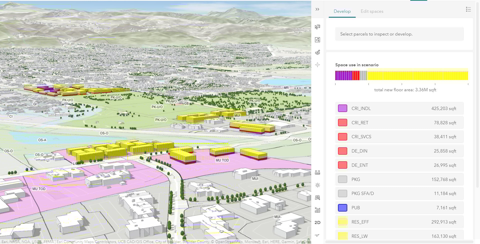
Using the concept development phase as the input, the planners quickly drafted land use scenario mock-ups using ArcGIS Urban. They were able to use the tool to quickly illustrate where the changes would happen, and what the new condition would look like against the existing condition. After presenting the initial draft scenarios to City Council and the Planning Board, and taking in their feedback, the planners molded their vision into four alternative future land use scenarios within Boulder’s ArcGIS Urban model.
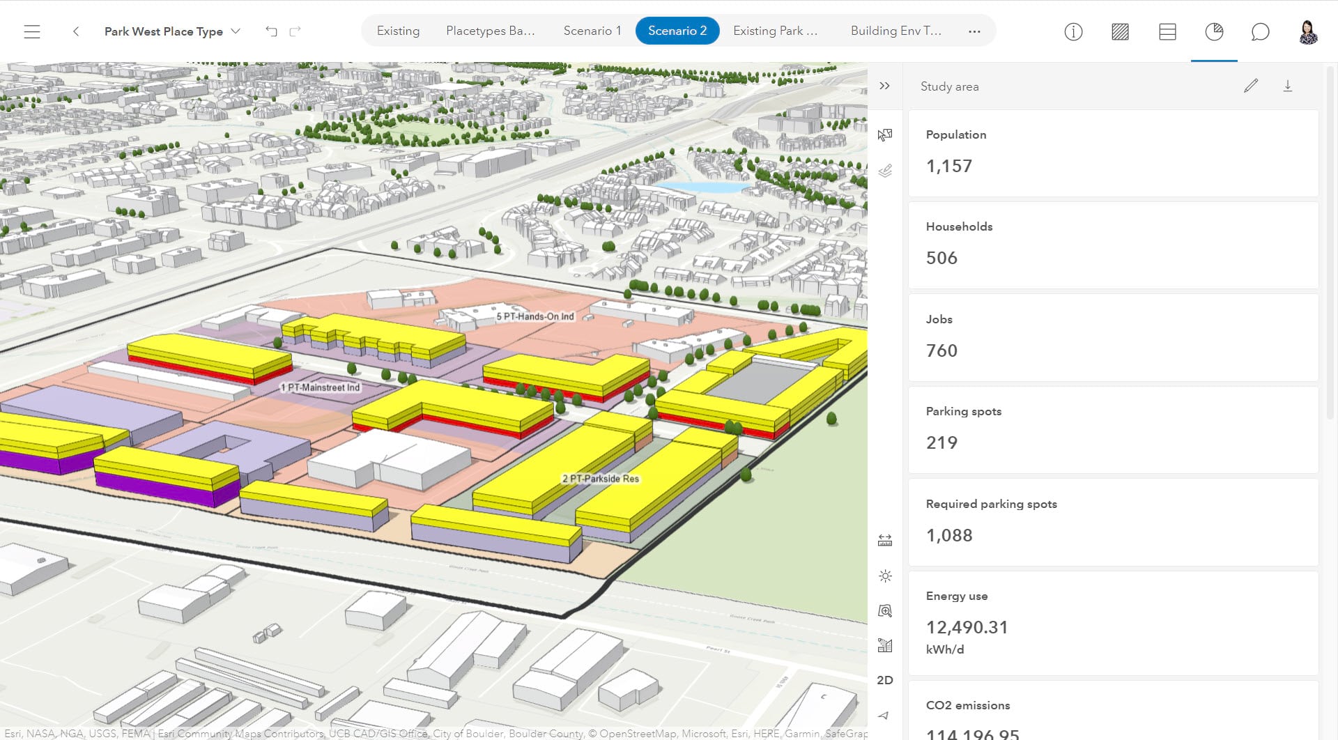
Leveraging the land use scenario editing tools available out-of-box in Urban, planners were able to create and modify land use parameters like Dwelling Units per Acre to report on key planning performance measures like Housing Units, Job Creation, and Carbon Emissions.
Each scenario sought to answer the question:
What will East Boulder look like in 2040 if we…?
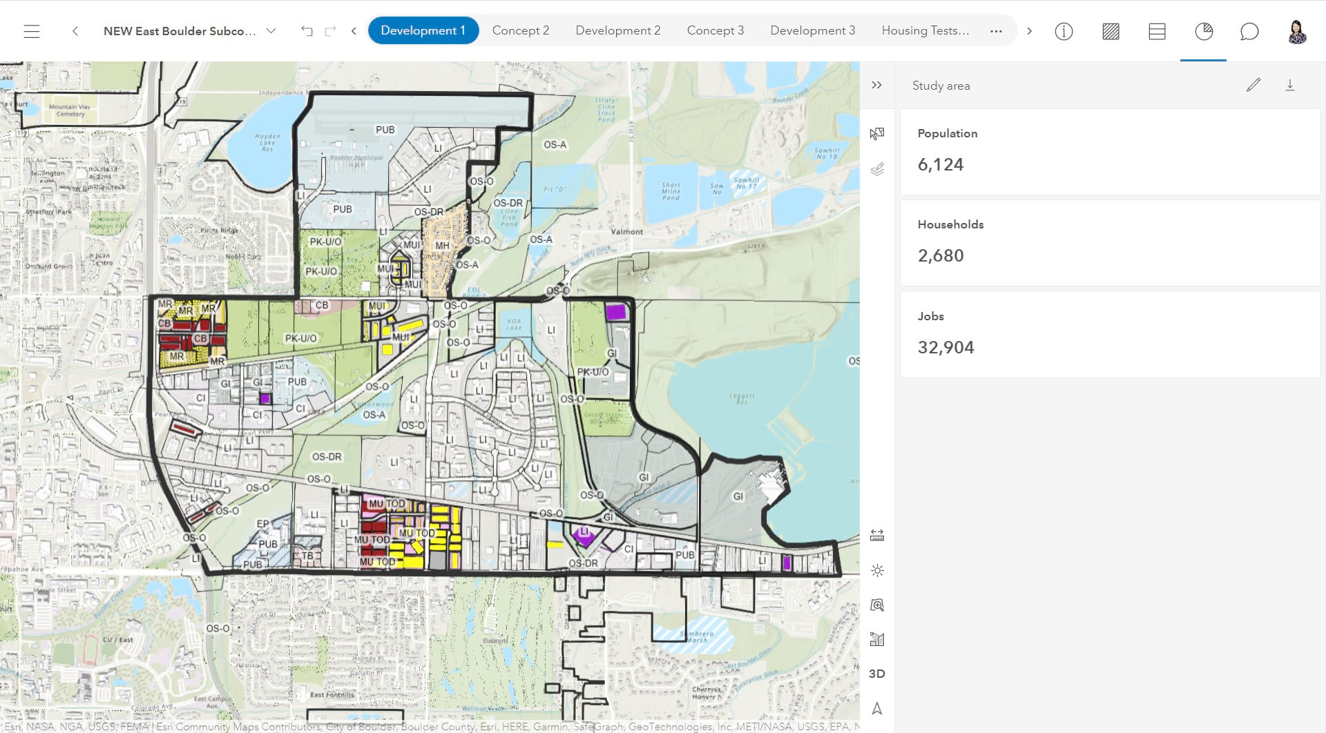
- No Land Use Change Scenario
This scenario looks at what East Boulder might look like if no changes are made to existing land use, specifically looking at the six focus areas that the community was most interested in redeveloping and rezoning. For example, if industrial land use remains in place, job growth will outpace housing growth, with only 300 new housing units expected. As a result, living will be further separated from work, leading to longer commute times, more trips, and higher carbon emissions, thus hindering Boulder’s goal to become a Net-Zero city by 2035.
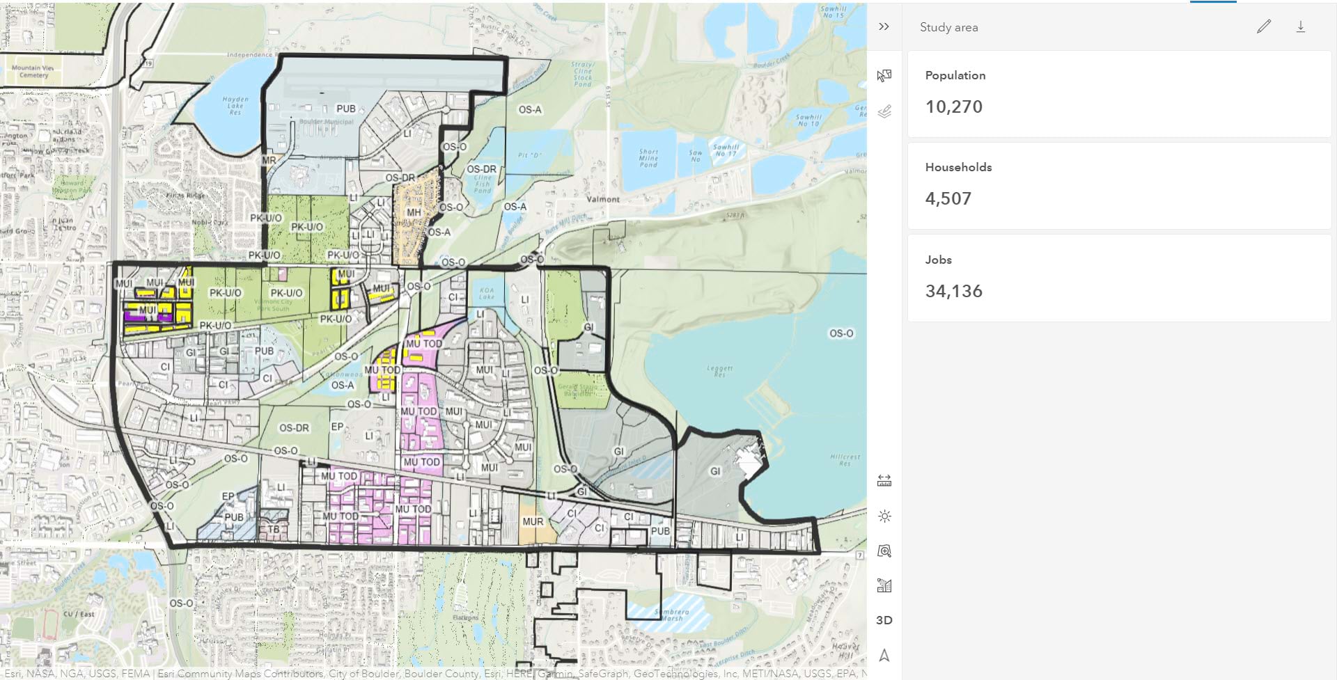
- Concept 1 Scenario: New Neighborhoods at Key Nodes
This scenario models land use changes at three key nodes and intersections that would essentially create new neighborhoods. This scenario will create 2700 new homes and will advance housing affordability and diversity with a mix of condos, townhome/duplex, and live-work structures. It will also bring in more service jobs from the mixed-use developments that will benefit the new residential neighborhoods.
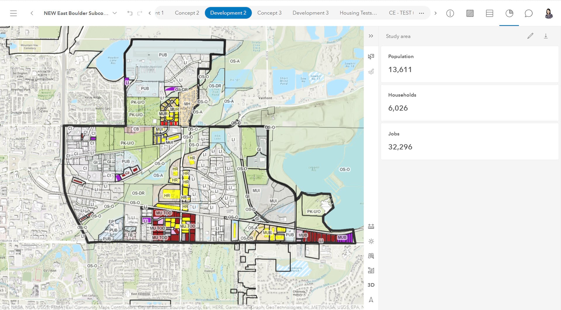
- Concept 2 Scenario: Residential Redevelopment along Major Corridors
In this scenario, land use regulations are modified to incorporate mixed use and residential redevelopments along major corridors, with a focus on creating different types of spaces: business focused area, residential mixed-use, industrial mixed-use, and new community park space. It also brings significant new homes by 2040 (6100 total), grows the medical and office jobs, and maintains more of the industrial jobs than the Concept 1 scenario.
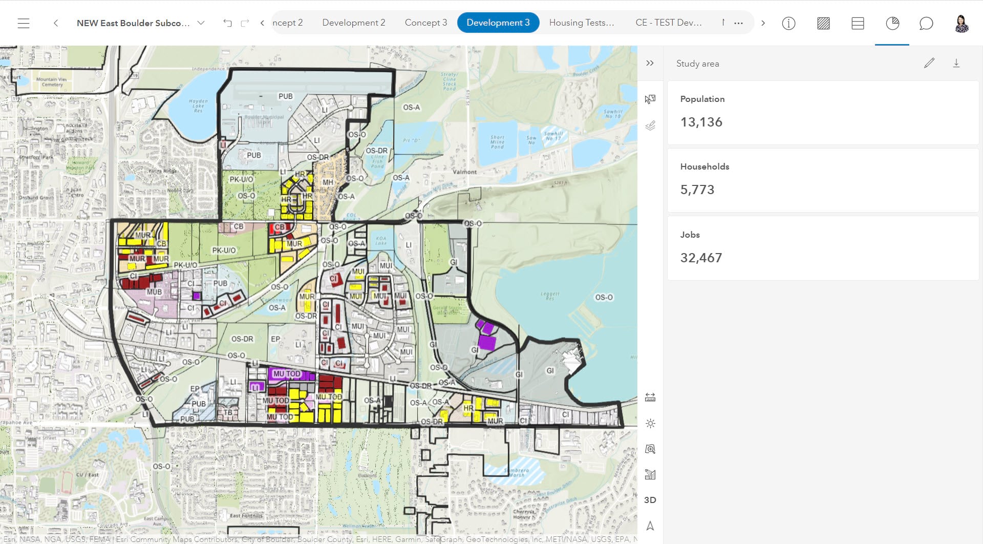
- Concept 3 Scenario: Mixed Use Redevelopment and New Green Spaces
This scenario considers the natural assets of the area, like local creeks and flood plains, and proposes land use changes to incorporate mixed use redevelopment to meet the city’s goals. The focus is to provide access to existing and new natural features from new residential neighborhoods. This concept could result in about 5900 new homes by 2040, with the majority being condos/apartments. With a significant increase in mixed-use areas, this concept will introduce a significant amount of office, retail, and service .
-
...
Making trade-offs and Reaching Consensus
Beyond the out of box space use types, building types, and capacity metrics, planners also created and localized their own types and parameters to evaluate land use change impacts. Specifically, they focused in on aligning with Boulder’s long term objectives on climate Change, resiliency, and housing affordability for example. Planners have shared the Indicator Methodology white paper of how the key metrics were calculated in ArcGIS Urban to allow the public to understand the “how” and “why” behind the scenarios.
We have a community that is interested in data, and we now have tools like [ArcGIS] Urban that allow us to measure and evaluate changes and policies using a more data-driven approach.
As part of the digital engagement with the public, planners created four videos to share the different land use concept scenarios and their impact. The scenario visualizations along with the capacity metrics allowed community members to quickly understand the trade-offs between the scenarios, voice their concerns, and weigh in on their preferences.
Based on the community feedback, planners combined Concept 1 and Concept 3 and created the preferred Land Use Scenario.
-
Preferred Land Use Scenario
Under recommendations of the preferred scenario, East Boulder will be contributing 2600 to 4400 new homes to the city’s housing stock by 2040, among which up to 1100 will be affordable based on the city’s requirements. While the recommendation still retains a significant amount of land prioritized for industrial use, some areas have changed from industrial to mixed use to allow the flexibility of integrating residential and retail over time.
It has been hard to put quantitative goals in a long-term perspectives and continue to measure how we are moving towards the goals incrementally through each project being built. Tools like ArcGIS Urban are helping planners to evaluate land use change impact in the long term, while also allowing them to evaluate projects in current planning on whether they are helping the community to move towards its goals.
Going Forward: 3D Visualization for Zoning Prototyping and Boulder’s Next Subcommunity Plan
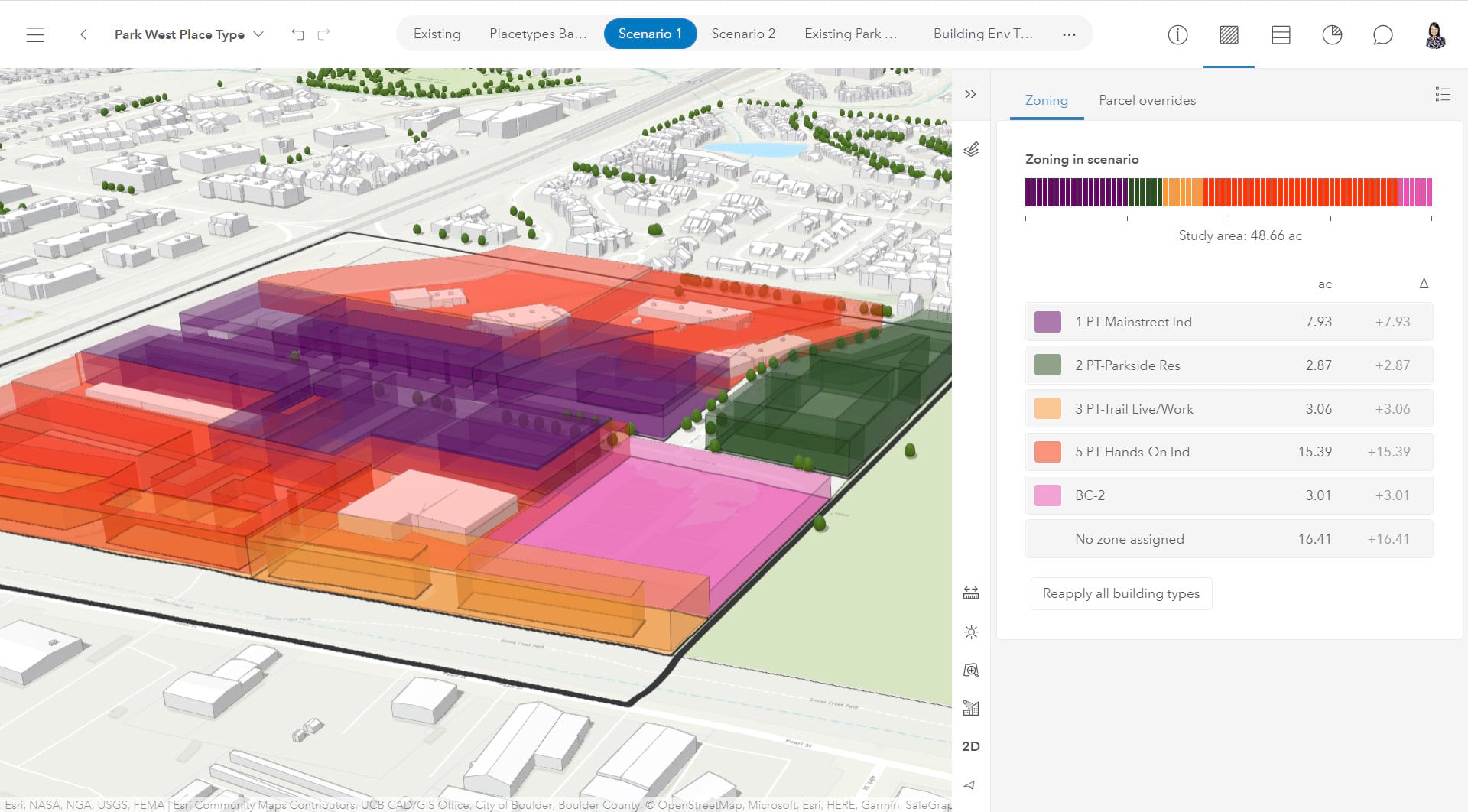
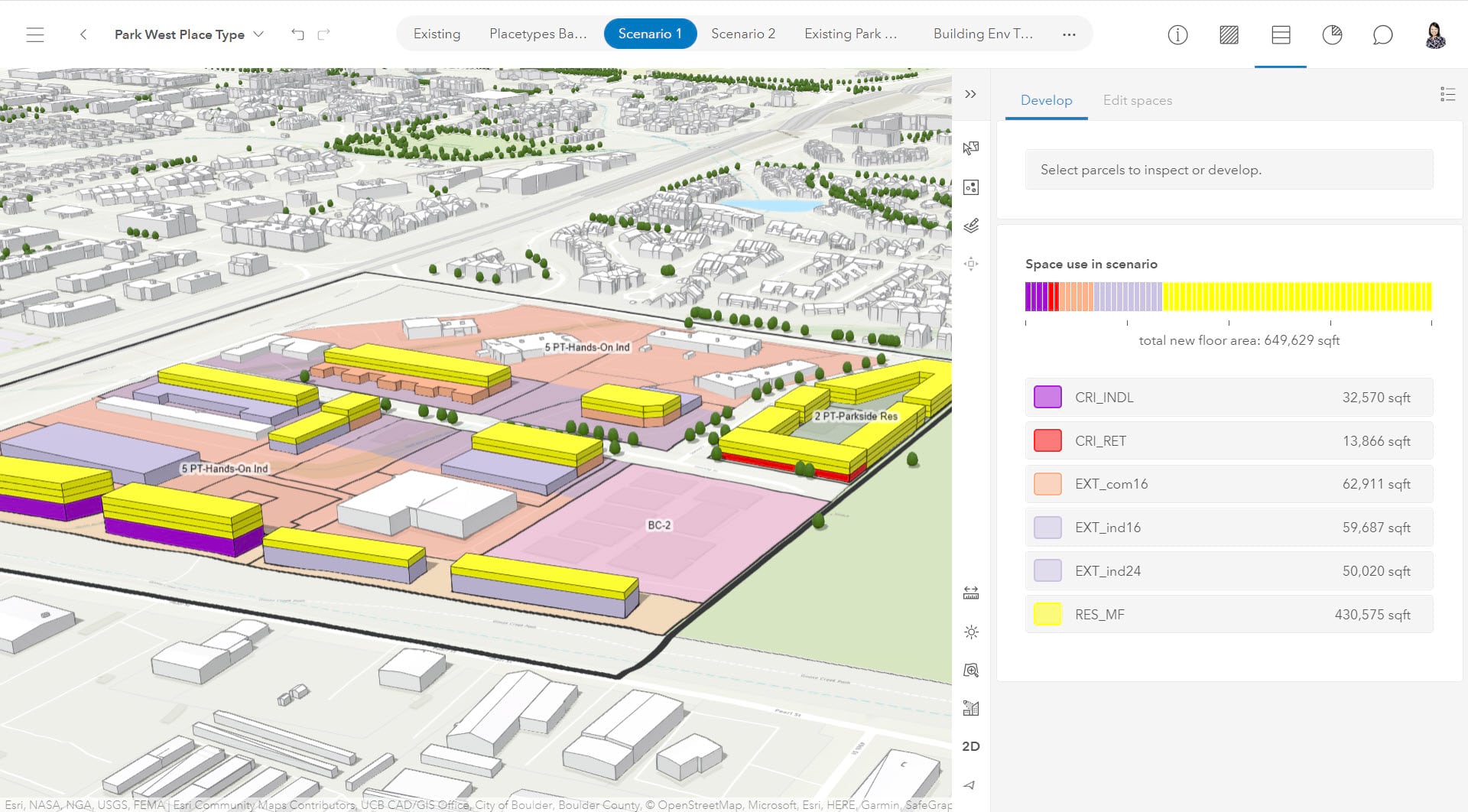
Moving forward, Kalani, the Urban Designer on the team, would like to take the preferred land use scenario a step further to develop realistic 3D visualizations. She plans to leverage the Zoning Plan features in ArcGIS Urban to create 3D massing study for the focus plan areas in East Boulder based on the land use changes. With the seamless integration between ArcGIS Urban and CityEngine, she will be able to take the 3D zoning scenarios from Urban to CityEngine to conduct rule-based urban design by configuring complete streets, building façade and ground features, and open spaces.
In addition, with the scenario planning process and approach established by the East Boulder Subcommunity Plan, Kathleen and the team are ready to launch the next Subcommunity Plan leveraging the process and land use standards that they’ve established in ArcGIS Urban.
There will be more to come in this blog series as we continue to follow the Boulder planners’ journey in innovating in both processes and technologies to plan for a more responsive, resilient, and sustainable future for their communities. Stay tuned!
-
Zoning Prototype - 3D Envelopes
Attributes
Special thanks to the amazing team from Boulder whose work inspired this blog and will undoubtedly inspire others to elevate the voice of their communities through scenario planning. Thank you to Kathleen, Kalani, and Jenny!

Kathleen is a Senior Planner in the City of Boulder’s Comprehensive Planning division. She manages Boulder’s Subcommunity Planning Program along with other long-range planning projects in the city. Kathleen is a licensed landscape architect and certified planner with over ten years of experience working collaboratively with communities across the country to envision and build memorable, inclusive places. Her work strives to integrate natural systems with the built environment to improve quality of life and habitat for all. Kathleen is passionate about the power of data to inform planning and design decisions. She has taught a graduate course called “GIS for Landscape Architecture” at the University of Colorado, Denver and is a regular studio critic at University of Colorado Boulder.

Kalani Pahoa is an Urban Designer in the Comprehensive Planning division at the City of Boulder.

Jenny Immich is a GIS Analyst with the City of Boulder, Colorado Planning & Development Services Department.

Great article, good to see how Urban is being used. The link for the indicator methodology does not work for me, any chance we could get that fixed?
Hi Graeme – thanks for the comment. The link should be fixed now.