Edit (5/31): Updated the wording for Advanced Editing user type extension to indicate that a separate license is no longer required for tracing.
The 2024 Network Management Release (ArcGIS Pro 3.3 and ArcGIS Enterprise 11.3) includes exciting new enhancements aimed at enabling you to maximize your investment with the ArcGIS Utility Network. This release also introduces the Utility Network Version 7 (UNv7) which brings valuable new features and enhancements including support for 64-bit Object IDs and big integer fields, the ability to perform directional traces using the digitized direction of the line, and more.
We understand that many who follow the network management release plan are likely upgrading directly from an earlier release. As a result, in this article, we will also explore some of the key features and improvements introduced since the previous Network Management release (ArcGIS Pro 3.1/ArcGIS Enterprise 11.1).
New with ArcGIS Enterprise 11.3
- The pane formerly known as Trace Locations
- Performance and logging
- Return subnetworks made dirty by a validate operation
- Isolation trace updates
New with ArcGIS Enterprise 11.2
Utility Network Version 7
ArcGIS Pro 3.3 and ArcGIS Enterprise 11.3 introduces the Utility Network Version 7 (UNv7), delivering schema changes to support new functionality for utility and telecom workflows.
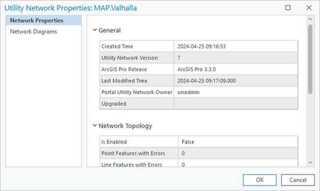
Recall that both the ArcGIS Pro and ArcGIS Enterprise releases determine the version of the utility network dataset that is created or upgraded to when working with an enterprise geodatabase. As a result, these capabilities are not available through feature services until the ArcGIS Enterprise 11.3 release becomes available. Until that time, you can begin to familiarize and prototype your workflows using a version 7 utility network in a mobile or file geodatabase.
As with all utility network versions, upgrading the utility network dataset is not a requirement unless you wish to take advantage of the new functionality. While many of the new capabilities in this release require a version 7 utility network, you can still benefit from some improvements made to the trace framework and editing experience while using any utility network version.
64-bit Object IDs
While 32-bit object IDs remain the default for tables and feature classes created in a geodatabase, 64-bit object IDs are created for all network classes and system tables starting with UNv7 to model datasets with more than 2.14 billion features. This migration also occurs on upgrade to a version 7 utility network. Due to this schema change, there are some items to be aware of before upgrading:
- First, ensure that the enterprise geodatabase version is upgraded to 11.2.0 or higher. 11.2.0 is the minimum enterprise geodatabase version to support 64-bit Object IDs and big integer fields.
- Create a backup before upgrading. Understand that the migration to 64-bit object IDs made with UNv7 cannot be undone and the dataset can no longer be used with previous versions of ArcGIS Pro.
- It is important to note that you cannot upgrade to UNv7 when replica tracking is enabled on any of the utility network classes. Replica tracking can be re-enabled following the upgrade if you need to configure your data for certain feature service synchronization workflows or for use in distributed collaboration.
- Finally, due to the schema changes made to support 64-bit Object ID, which involves dropping and recreating indexes for all utility network tables, understand that the upgrade process may take longer than experienced with previous upgrades.
To review the other schema changes made with the UNv7, reference the Utility network upgrade history.
Big Integer Support
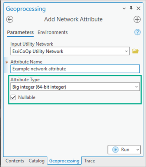
In addition to 64-bit Object ID fields, UNv7 also introduces support for big integer fields and their use with network attributes. Big integer network attributes are beneficial when working with large values which exceed those supported by long integers in a trace, or to generate summaries on the SubnetLine feature class. While it is not possible to migrate existing fields to a big integer field, you can leverage these through the creation of a new field followed by a field calculation to copy over any existing values.
Use Digitized Direction
The Trace and Add Trace Configuration tools now support the ability to configure a directional trace using the digitized direction of the line in a UNv7 dataset. A new parameter, Use Digitized Direction, is available when performing upstream or downstream traces in your network.
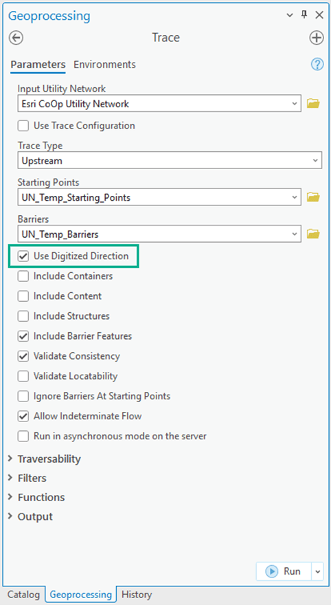
This feature is beneficial if you use a model that relies on the digitized direction of lines to determine the direction that resources flow. This should not be used if you are currently modeling flow using subnetwork controllers.
On upgrade to UNv7, a new FLOWDIRECTION field is added to each line and edge object class, and the flow direction network attribute is assigned with a default value of ‘With digitized direction’. By default, flow direction is based on the digitized direction of the line and the From and To Global ID for edge objects in the Associations table. When working with an enterprise geodatabase this also requires the supportsFlowDirections capability introduced with ArcGIS Enterprise 11.3.
New with ArcGIS Pro 3.3
Let’s now turn to functionality introduced with ArcGIS Pro 3.3 which can be used with all versions of the utility network.
Rebuild Network Topology
A new Rebuild Network Topology geoprocessing tool and Rebuild current extent command are now available for use with all utility network versions hosted on ArcGIS Enterprise 10.9 or later.
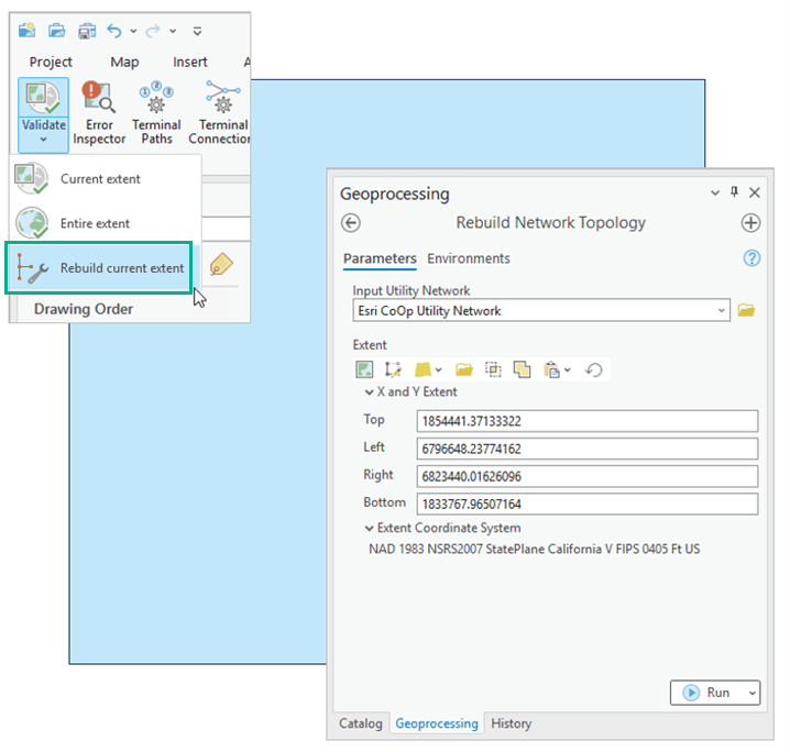
These tools allow you to rebuild the network topology within a given extent and are particularly useful when addressing issues that arise during validation for specific areas of the utility network. The rebuild operation reconstructs a given extent of the network topology, ignoring any dirty areas, and rebuilds all features in the specified extent. While the geoprocessing tool and Rebuild current extent command perform the same operation, the geoprocessing tool performs the operation asynchronously which may be better suited to operations run at small scales or against a large number of features.
Synthesize Geometries
A new Synthesize Geometries parameter is available in the Output section of the Trace and Add Trace Configuration tools when using the Aggregated Geometry result type. Enabling this parameter allows you to infer and create (synthesize) geometries for associations and edge objects traversed during a trace in the result.
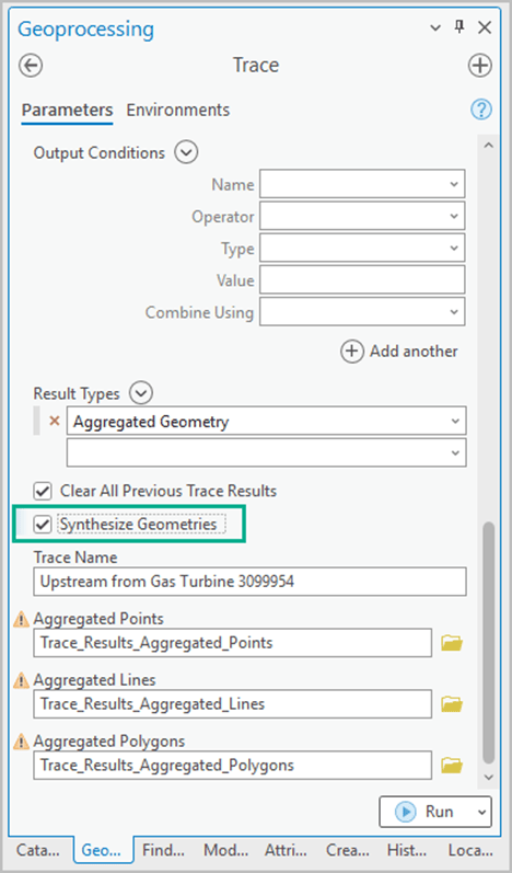
This functionality extends the capabilities of aggregated geometry to visualize the path of a trace through associations and edge objects and can be a valuable tool for understanding the connectivity and relationships within your utility network, especially in cases where traces are run against predominantly nonspatial objects. As with all aggregated geometry results, the use of apportionable network attributes allows you to return partial feature results based on the location of barriers.
Geometry can be synthesized in two ways: using the geometry of an edge object’s spatial container, or between the endpoints of an edge object or association.
When an edge object is contained by a line, the geometry is inferred from the spatial container, providing a clear representation of the object’s location. In cases where an edge object doesn’t have a spatial containment, geometry is synthesized between its endpoints using a straight line, which is also the method use to synthesize association geometry.
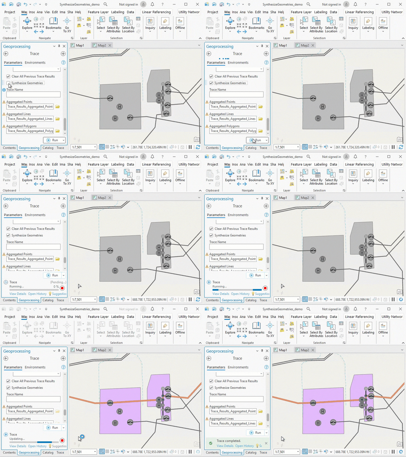
It’s important to note that while the Synthesize Geometries parameter does not require UNv7, the supportsTraceSynthesizeGeometries capability introduced with ArcGIS Enterprise 11.3 is required when working with an enterprise geodatabase.
Subtype group tables
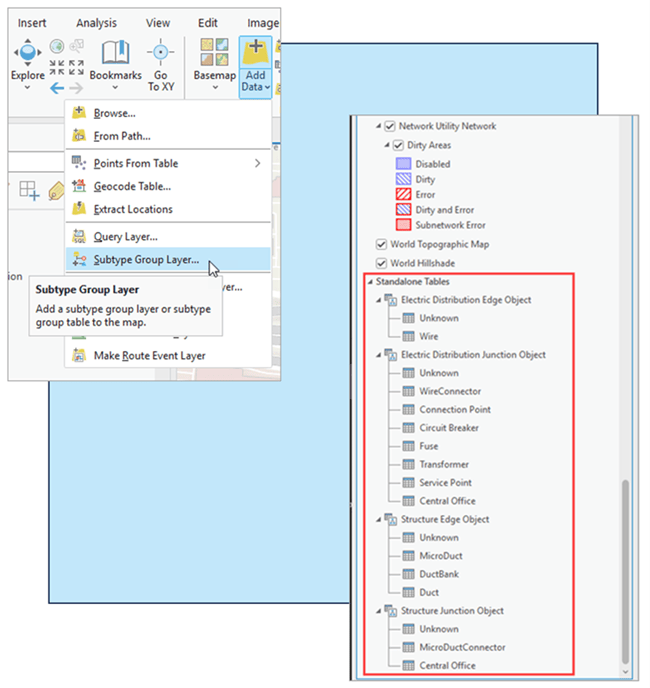
Subtype group layers have always been an important capability that utility network customers use to organize their data. With ArcGIS Pro 3.3 this capability has been expanded to work with tables. This means that you can now create a composite layer to group nonspatial objects by subtype. By grouping these objects, you can manage and interact with them more granularly than before.
Snap chip
ArcGIS Pro 3.3 introduces an improvement for snapping when editing. The Snap Chip improves the user experience when editing features in a congested map area to allow finer grained control over which features are connected. This is of interest to those working with the utility network as it lets you assign terminal connections on the fly when connecting a line to a terminal device.
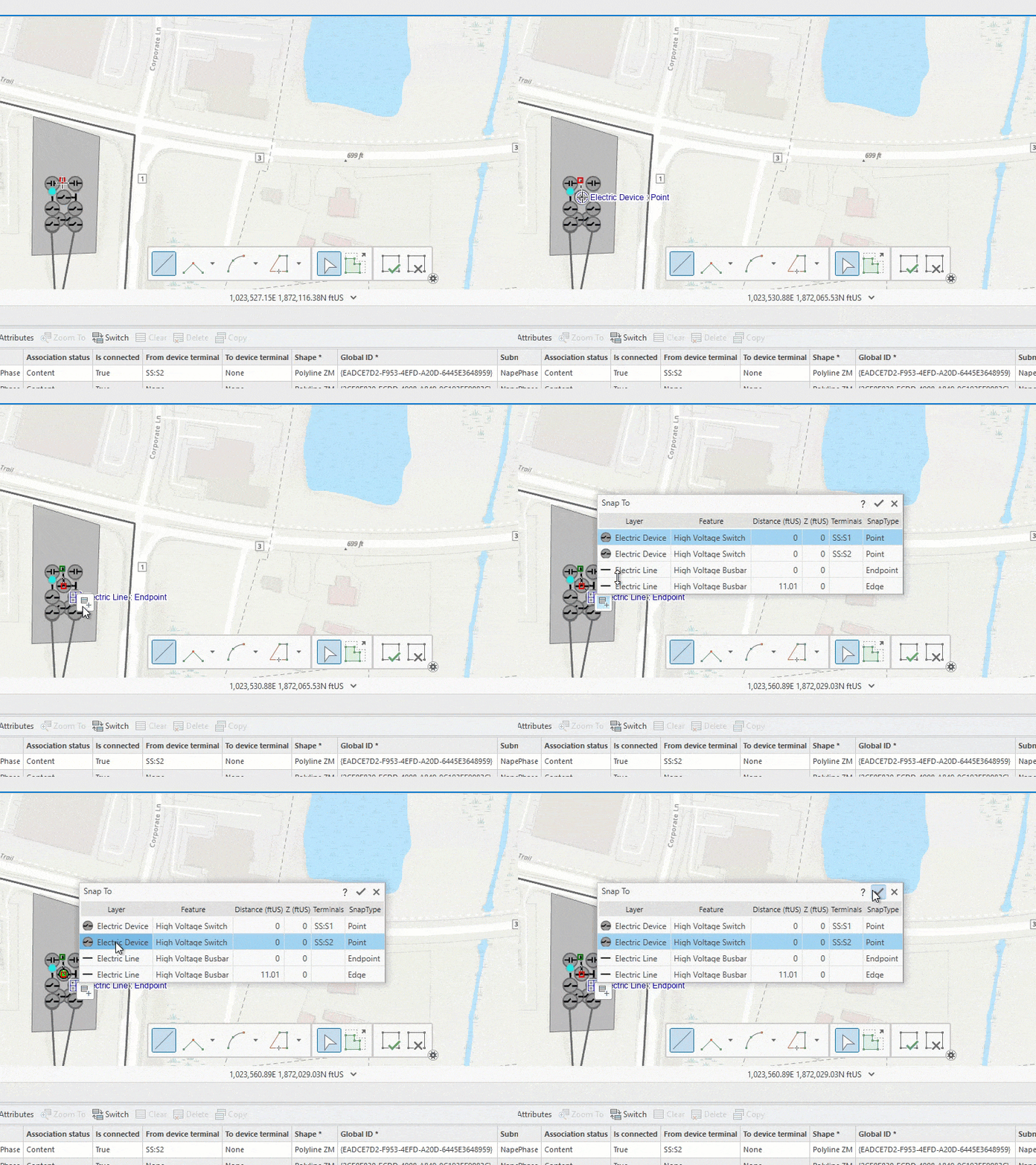
While the Modify Terminal Connections pane remains the default method for establishing junction-edge connectivity, the snap chip offers a streamlined experience for some workflows.
New with ArcGIS Enterprise 11.3
Much of the functionality introduced with ArcGIS Pro 3.3 in the 2024 Network Management Release relies on the companion release of ArcGIS Enterprise 11.3 when working in an enterprise deployment. To fully leverage the improvements in this release in an enterprise deployment, it is essential to work with both ArcGIS Pro 3.3 and ArcGIS Enterprise 11.3 as the server-side capabilities introduced with ArcGIS Enterprise 11.3 enable the creation of a UNv7 to support various other enhancements.
Partial posting by selection
One capability introduces specifically with ArcGIS Enterprise 11.3 is support for partial posting of a selection set which includes utility network features. While the ability to post a subset of edits to the default version has been supported since ArcGIS Enterprise 10.9, you can now include a selection of utility network features in the rows parameter of the Post operation.
New with ArcGIS Pro 3.2
As promised, if you missed the new functionality introduced in the previous release, we’ve got you covered here.
The pane formerly known as Trace Locations
In ArcGIS Pro 3.2, the Trace Locations pane received a facelift and was rebranded as the Trace pane. Why? Because this pane now enables you to do so much more than place trace starting points and barriers. The Trace pane now provides a centralized location to perform traces in your utility network when working with named trace configurations.
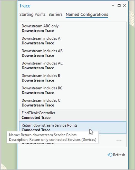
While this offers a similar experience to loading a named trace configuration into the Trace geoprocessing tool, the Named Configurations tab on the Trace pane provides the added benefit of bypassing the geoprocessing framework, which can improve performance when running traces.
Performance and logging
The ArcGIS Pro 3.2 release also introduced various performance and logging improvements for trace, validate, and subnetwork management workflows. On the logging front, we specifically expanded the information presented within the Diagnostic Monitor to cover additional workflows such as exporting subnetworks, and to include additional information on the overhead associated with REST and the geoprocessing framework.
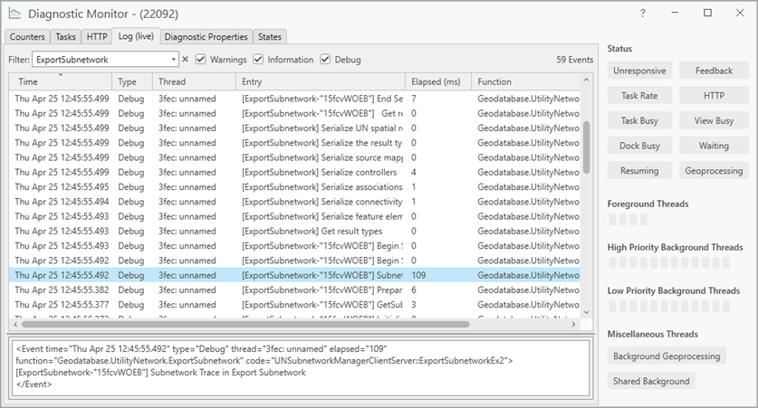
Return subnetworks made dirty by a validate operation
Following previous updates made to the validateNetworkTopology operation in the REST API with ArcGIS Enterprise 11.1 to report discoveredSubnetworks, the Validate Network Topology tool was updated in ArcGIS Pro 3.2 to return the subnetwork name, domain network, and tier for any subnetwork that is marked as dirty by the operation.
The JSON is presented in the tool’s Parameters tab whereas the Messages tab presents this information in a tabular format.
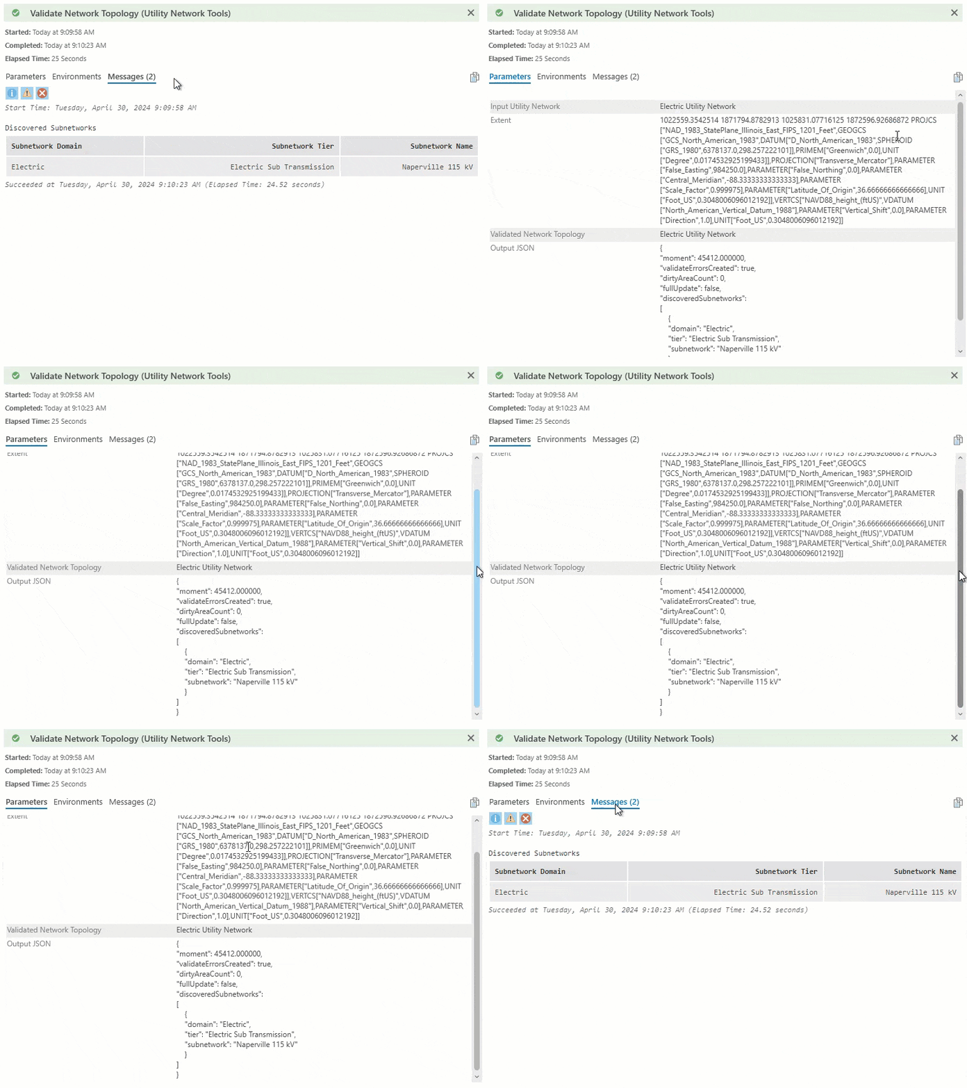
Isolation trace updates
When performing an Isolation trace with the Include Isolated Features parameter checked, the Include Barrier Features parameter is now available and enabled by default. This allows you to include or exclude the isolating barrier features in the trace result.
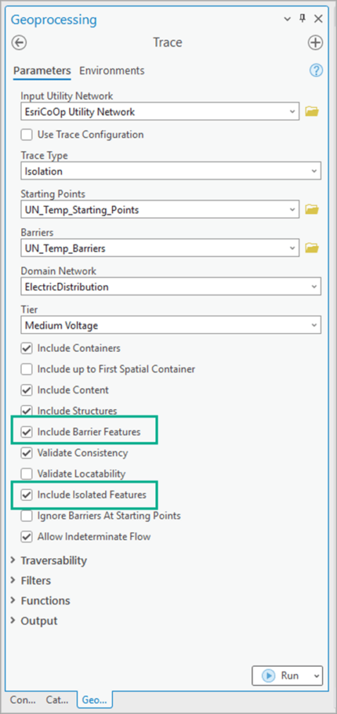
New with ArcGIS Enterprise 11.2
Advanced Editing user-type extension
Beginning with ArcGIS Enterprise 11.2, the ArcGIS Utility Network is licensed using the ArcGIS Advanced Editing user type extension.
The most significant benefit of this change is that starting with ArcGIS Enterprise 11.2 and beyond all client applications that perform tracing using a utility network or trace network will no longer require a user-type extension.
The ArcGIS Advanced Editing user type extension enables advanced editing and geodatabase capabilities in ArcGIS Enterprise. This new user-type extension streamlines licensing, placing three existing ArcGIS Enterprise user type extensions (ArcGIS Utility Network, ArcGIS Trace Network, and ArcGIS Parcel Fabric) into a single package. This license will also enable advanced editing and geodatabase capabilities as they come to web and native device apps.
This is included in the GIS Professional Standard and GIS Professional Advanced user types and can be assigned as an add-on license to members with the Editor, Mobile Worker, Creator, and GIS Professional Basic user types.
To learn more, check out this article Introducing the ArcGIS Advanced Editing user-type extension.
Learn More
We hope the details outlined in the above sections have provided some good food for thought aon how they may improve your organization’s use of the utility network. If you want to dive in deeper and learn more, review the help documentation to learn more about the highlights covered in this article.
Do you have questions about current or upcoming functionality in the utility network, visit the ArcGIS Utility Network community site to discuss them with other like-minded professionals.
If you want to learn even more about the utility network, check out the various learn paths available for the ArcGIS Utility network on learn.arcgis.com:





Commenting is not enabled for this article.