ArcGIS is a comprehensive geospatial platform for professionals and organizations. It is the leading geographic information system (GIS) technology and provides capabilities for creating, managing, analyzing, mapping, and sharing all types of data. It is ArcGIS that can help your utility or telecom company achieve digital transformation, which is critical in tackling today’s challenges.
Technology is key to this transformation, and location plays a huge role. As GIS continues to grow and evolve, it enables utilities and telecoms to transform their environments digitally into a modern system of systems that all work seamlessly together. Data is flowing freely using geography as the common thread. ArcGIS supports essential business operations and sets the stage for your utility or telecom to expand its use of ArcGIS. This helps you manage network data and assets, field crews, imagery data, emergency response, and community engagement.
An ArcGIS Network Information Management System is an implementation pattern that lets you use GIS to model, visualize, and manage your network information. Let’s dive deeper into Network Information Management!
What is a Network Information Management System?
An ArcGIS-based Network Information Management System is a system of record for managing and analyzing your utility or telecom network features and relationships across multiple lifecycle phases. This comprehensive ability to manage all the complexities of a modern network comes with advanced analytics and visualizations. It is made available across the entire organization through pervasive access between business units.
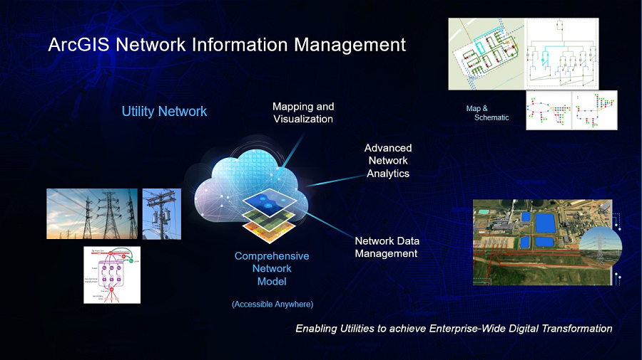
A Network Information Management System is flexible and scalable, whether you’re a small, large, or growing utility, or a massive telecom with billions of fiber strands you need to model. You can start with simple mapping of network assets to get a clear picture of your network. You can gradually add more detailed data about your network assets, as your business needs and requirements evolve. If you need to manage network topology and connectivity, you can use ArcGIS Utility Network.
ArcGIS Utility Network allows you to manage a connected network with a single unified information model. It enhances an ArcGIS-powered Network Information Management system with advanced capabilities and provides a connectivity model for modern utilities and telecoms.
In 2025, Esri introduced implementation options for Network Information Management, so you can become accustomed to ArcGIS Utility Network (or a non-network option) at initial starting points at your own pace. Let’s revisit each of these options.
How can I implement a Network Information Management System?
We have options for you to choose how to get started building your Network Information Management System with ArcGIS. Depending on your business needs and existing technology infrastructure, we’re here to help you reach your goals, from simple mapping of your network assets, all the way to a full network digital twin with our industry standard models.
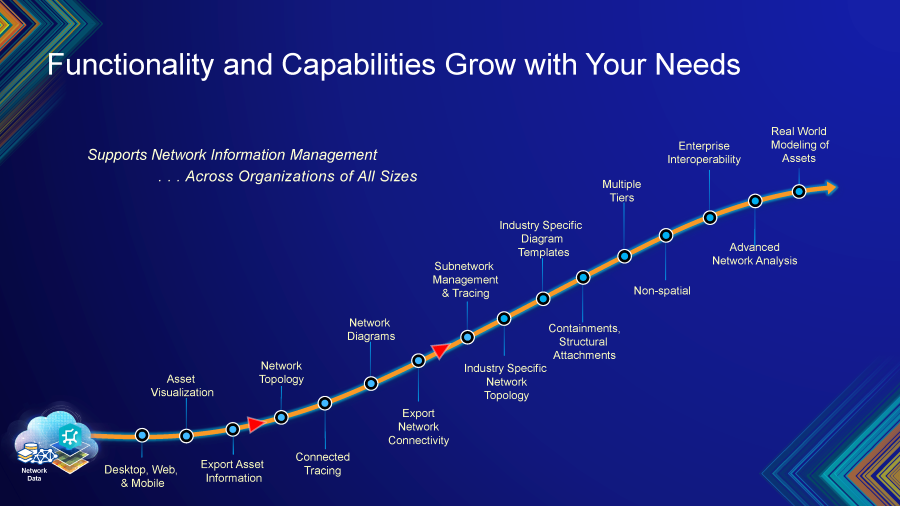
Whatever type or size of utility or telecom, we have a Network Information Management solution for you. We have resources, migration tools, service packages, and Esri Partners to support you every step of the way as you grow to adopt these capabilities. Here’s a breakdown of our implementation options:
Option 1 – Non-topological Data Model
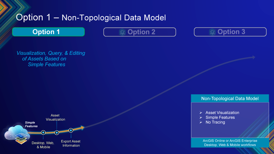
If you don’t need network connectivity right away, Option 1 is a great starting point. You can map and visualize your network assets with an ArcGIS Solution that includes a standard data model and pre-configured utility data management apps for both the office and field. This option can be set up quickly to get your utility or telecom up and running in no time.
In this model, assets are represented as simple features—points, lines, and polygons—with no underlying topology, which means tracing capabilities are not available. However, you can still create maps and view your assets using desktop, web, or mobile applications.
Option 2 – User or Organization-defined Data Model
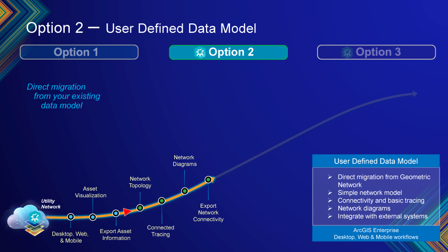
Option 2 is where ArcGIS Utility Network is introduced. The Migration toolset for ArcGIS Utility Network was released with ArcGIS Pro 3.5, and allows you to migrate data from an existing Esri GIS dataset into a utility network with a matching schema. This option uses a simple network model that builds upon the same modeling capabilities from before migrating to Utility Network, adding features that ArcGIS Utility Network provides. This includes topology, integration with external systems, connectivity and tracing, and network diagrams.
As your business needs evolve and the need for more advanced network capabilities grows, your GIS and utility network will grow with it. Choosing option 2 doesn’t mean your utility network has limited capabilities. Instead, it means that you are starting your journey with a simpler model and will configure additional capabilities over time. If your business doesn’t require or isn’t ready to implement the more advanced capabilities yet, then you will likely choose option 2. However, if your organization is ready to embrace the advanced capabilities of a modern network information management system, then you should plan on implementing option 3.
Option 3 – Industry-defined Data Model
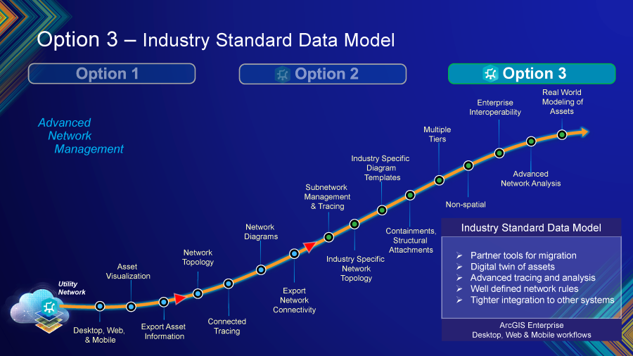
Option 3 delivers all the advanced capabilities of ArcGIS Utility Network. You can create a full digital twin of your network, using a Utility Network foundation from ArcGIS Solutions or our Network Management Specialty Partners. Build subnetworks and containers to get the most detailed model of your network and its assets. Use Esri’s industry-defined data models to build your network with pre-defined rules and attributes tailored to your specific industry.
A key benefit of using an industry-defined data model is seamless interoperability with external systems, such as Advanced Distribution Management Systems (ADMS), Outage Management Systems (OMS), and other downstream applications. This facilitates efficient data exchange and integration across enterprise workflows, enabling utilities and telcos to leverage their network data more effectively.
Choosing the right domain for your industry
If your organization determines that its business needs require ArcGIS Utility Network (an option 2 or 3 implementation), it is important that you understand domains and which one is right for you. Domains are the data structure and properties that tell the utility network the kind of system it is going to manage. Domains provide the framework of the network to be built. They are part of a bigger decision model that helps determine what capabilities will be leveraged within the network and the types of tools that will help a user perform their necessary business processes.
In addition to the structure domain which is where all of the structural elements are of the network are stored, you can add a traditional domain. This domain can be enabled to facilitate the type of commodity flowing through the network that we need to be able to map. This is defined by tiers. Partitioned tiers are for the wires and cables of electrical or communications networks. Hierarchical tiers represent pipe networks commonplace for water, sewer, gas, and other pipeline industries.
We are also introducing a new domain type, the telecom domain. With the new capabilities in the telecom domain, you will be able to activate a utility network system that has tools designed and curated to meet the needs of your industry. Enhancements like the ability to easily map non-spatial features using new grouping techniques, tracing that works the way you do your work, and advanced circuit management practices that replicate the real-world scenarios telecom companies deal with on a daily basis can all be found utilizing this domain.
Ready to get started?
ArcGIS uses the most advanced network information model, ArcGIS Utility Network, built on top of the industry-leading enterprise GIS software. Digitally transform your utility or telecom to meet today’s needs and prepare for the future with an ArcGIS-based Network Information Management System.
No matter which option you choose to begin your Network Information Management System implementation, Esri and its partners will be there to support you every step of the way. We’re committed to providing multiple implementation options, migration tools, and support services to help your utility or telecom reach its goals at a pace that feels right for you.
Come visit us in San Diego at Esri User Conference 2026
We’ll be there to answer your burning Network Information Management questions. Use our Utility Network and Telcom custom agendas below to add sessions to your schedule and to create your own Network Information Management User Conference experience.
ArcGIS Utility Network custom agenda: https://event.esri.com/widget/esri/26uc/1775670582198001XCMU
Telecommunications custom agenda: https://event.esri.com/widget/esri/26uc/1778095490411001hbMc





Article Discussion: