Pop Quiz – what was the name of early GIS at utilities? (Answer below)
Maps have been an essential tool for utilities since their inception. With all the discussion around how ArcGIS Enterprise and ArcGIS Utility Network are revolutionizing the way, utility companies operate it only seemed appropriate to re-examine the history of GIS at utility companies and see how far we’ve come and where we’re going.
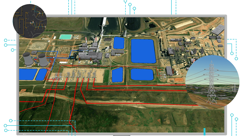
Why are maps and GIS so important to utility companies? The reason is simple: Electric, gas, and water utilities have their “stuff” (assets) spread up and down every street and back alley of their entire service area. The enduring problem they have faced throughout their history has always been about this stuff.
- What stuff do I have?
- When was that stuff last inspected or maintained?
- …and most importantly, where is my stuff?
Naturally, maps provided an answer. Utilities took map books, like Thomas Brothers, and penciled in their valves, wires, and poles on these commercially available maps. For the task at hand, at the time, that was adequate; however, as the utilities grew, so did the complexity and importance of the maps. After all, the performance of the utility workers depended on how long it took to locate their assets. Confusing or outdated maps increased the time to get where they needed to go. As these maps were hand-drawn, every worker maintained notes on their maps, making the update process even more error-prone and time-consuming. Inevitably this also led to many copies becoming outdated.
Over time, these maps became more problematic and the impact on the operational performance required a new solution.
The solution to the problem was to automate the maps – to digitize them. Thus, the first generation of GIS at utilities was born. The early GIS at utilities was not called GIS at all. These digital mapping systems were dubbed AM/FM or automated mapping/facilities management system, a curious name given its connotation with radio broadcast systems. These early systems attempted to automate the manual mapping process, and they succeeded; however, this only solved the map creation problem.
The early systems took only baby steps.
GIS Remained in the Back Office
During this time, nearly every utility migrated their old hand-drawn maps to digital, copying both the good and bad data into digital form. The result was a single mapping system that was cleaner, easier, and faster to update. Yet, the value of the results and the maps themselves remained largely unchanged.
Many utilities spent excessive time and effort to ensure they could use digital maps to print out replicas of their old paper maps, warts, and all. Instead of developing strategic new ways to use the maps, time was spent tinkering with the look and feel of the maps and the workflows remained the same. First, update the maps from field notes and phone calls from the crews by hand scribbling red lines on the maps. Then after the GIS technicians made the updates, copied, and distributed the maps to the field offices, utilities replaced the old marked-up maps with the newly printed ones.
Whew! Aside from creating the maps, the process was the same as the old paper map process. They continued their baby steps.
At some point, utility managers looked at the maps and thought they saw far more potential in their use than they were currently doing. They then began to think strategically about the data on the maps. Could they be used for gas leaks, power restoration, or water main asset management?
Maturing into Enterprise GIS
Once it dawned on utilities that GIS was worth much more than the paper it was printed on, the next generation was born. Focus shifted from paper to data and work began in earnest to improve the data and create applications to solve pressing utility problems. The drive toward a quantum leap had begun. It was no longer acceptable to have a kind of accurate representation of the assets. Instead, it became critical to have an accurate, up-to-date, complete model of the utility network.
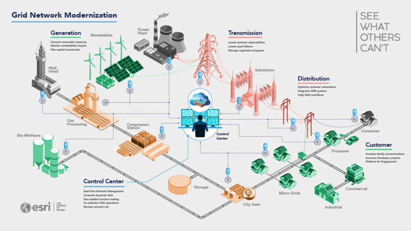
Work began to move the GIS from a back-office niche application to a full-fledged enterprise system. Utilities needed to drag the GIS kicking and screaming out of the back office into every nook and cranny of the utility enterprise. They saw that GIS was critical in the field where the assets reside and also in the executives’ hands. Get it everywhere. Once utilities understood that GIS was a strategic enterprise system, they realized they needed to work on their data’s reliability, accessibility, and extensibility.
These are the three advantages that an enterprise GIS provides:
Data Reliability
The data must be pristine to become truly enterprise-quality. We often speak of the GIS as a foundation for the digital twin. This foundation is only as solid as the data it contains. The first step is to renovate the way the data is managed. ArcGIS Utility Network provides rigorous data checking and quality assurances of the data before it is part of the enterprise. That takes care of the new data. In addition, ArcGIS has built-in mobility capability which allows data to be corrected directly from field observations and as-built conditions without going through that arduous and clumsy process of making field notes, sending them to the GIS groups, and making updates days, weeks, and even months after things change in the field. Everything has to be done in near real-time. This process takes care of the legacy data issues.
Users must be able to trust all content presented in the GIS. Because the GIS is tied into so many different systems of a utility, it is usually the first system to identify a data problem. Fortunately, this means it is also used to research issues since it can quickly compare data from multiple systems. Some utilities have even begun to use GIS with machine learning and artificial intelligence to answer questions for their organization.
Accessibility
One of the best ways to attain a quantum leap in GIS usage is to make the GIS accessible to everyone in the enterprise and, frankly, even to stakeholders outside of the utility. As with social media, sharing is something a modern GIS does very well. ArcGIS Hub is a breakthrough technology that provides stakeholders, with permission, the ability to see firsthand what’s happening at the utility. This technology has been successfully deployed in areas of wildfires to alert communities about power shutoffs.
Utilities also use ArcGIS Online to host data and maps in the cloud. In some cases, this is used to provide public-facing outage maps. In addition, utilities often use this to quickly deploy targeted apps and data to field crews who may not have internet access while in the field.
Enterprise GIS is available everywhere you look. You’d be hard-pressed to find any other system so widely used across different industries and aspects of our lives. Experiences can be curated for desktop, web, and mobile users and supports workflows in the office, in the field (connected and disconnected), and even to the public. Accessibility doesn’t just apply to end-users. It applies to nearly anyone involved in the use of the data.
Extensibility
ArcGIS provides an enormous variety of extensibility and integration points. An administrator can configure almost every aspect of the user experience to meet everyday customer needs. ArcGIS Experience Builder and ArcGIS Field Maps let enterprise users create robust, configurable web and mobile experiences.
Those who want to keep it simple can use the extensive out-of-the-box capabilities of ArcGIS.
More specific behaviors can be developed by creating extensions and scripting. Techies who love to dabble with more advanced capabilities can use languages such as Python, JavaScript, and C# to create fascinating experiences. These same languages and techniques can even be used to create unique workflows and entire applications from scratch.
Making the Leap
GIS has moved from baby steps in the back office to front and center in the enterprise.
GIS has lingered in the back office with the plotter for several decades. While it served its purpose, ArcGIS Enterprise and ArcGIS Online have allowed GIS to emerge as a full-fledged enterprise system. Utilities are also leveraging the intelligence and power of the ArcGIS Utility Network to allow the GIS to take its place alongside critical systems such as ERP, AMI, and SCADA. Utilities see that GIS can integrate with these systems and act as a place where the information comes together to provide analytics that leverage all systems. You can learn more about how ArcGIS Enterprise and the ArcGIS Utility Network support modern utility requirements by downloading this technical paper.


Commenting is not enabled for this article.