City and county leaders are heading into 2026 asking very practical questions:
- How do we keep development projects moving?
- How do we maintain community trust?
- What is the best way to respond to mounting pressures on housing, resilience, and compliance with limited staff and budgets?
Across professional organizations, the throughline is clear. Local governments need systems that connect data, people, and decisions, and GIS is increasingly the backbone of that work.
5. Housing is a System, Not Just Units
NLC and APA’s Housing Supply Accelerator explicitly calls for a “systems” approach linking land use, infrastructure, permitting, and finance rather than treating housing as a stand-alone silo. Local leaders will focus on where additional housing belongs and how it fits within existing networks of services. They also need to understand what combination of capacity, affordability, density, and housing diversity will work,
ArcGIS as a Planning System enables planners to map and analyze the full housing pipeline. From zoning capacity (both existing and proposed) and infrastructure constraints to permitting backlogs and preservation opportunities, ArcGIS presents these on a single, shared canvas. Instead of a vague “build more housing” message, planners can use data-driven spatial analysis to identify specific sites where regulations, infrastructure, and market conditions align. ArcGIS even shows where targeted changes can unlock supply without overloading systems.
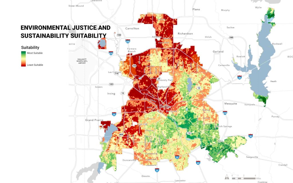
4. Integrated Community Resilience Planning
ICMA’s recent conferences and toolkits emphasize resilience as an integrated agenda. This spans infrastructure reliability, local economies, social connections, and hazard preparedness. Local governments will increasingly frame resilience by how well their community can withstand and recover from natural disasters, economic shocks, infrastructure failures, and public health events.
ArcGIS allows planners to bring multiple dimensions of resilience into one place. Overlay hazard maps, critical facilities, business activity, social indicators, and cultural assets in a single view. With that integrated view, planners can coordinate with public works departments to prioritize capital investments, target main street and neighborhood initiatives, and coordinate with emergency management and economic development on shared resilience goals.
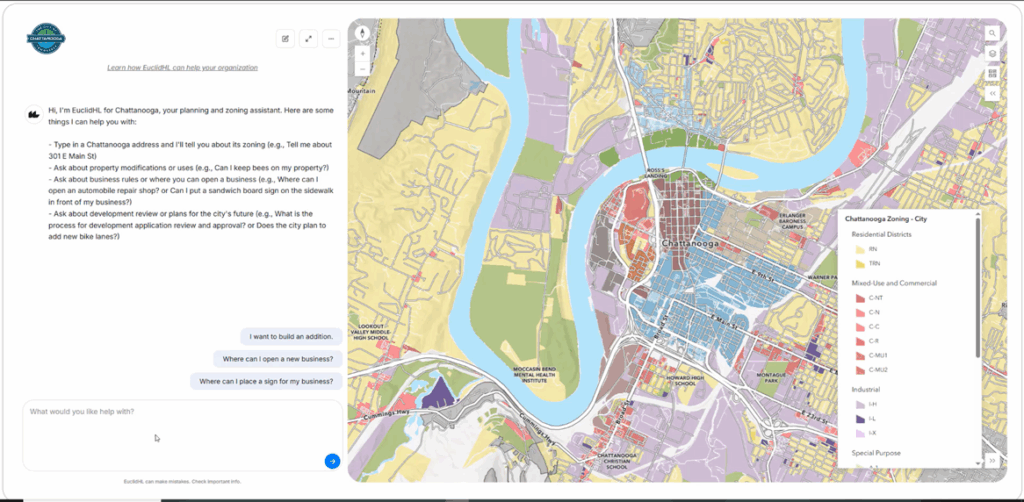
3. Data Governance and Responsible AI
The planning community has been quick in its early adoption of AI tools. As local governments pilot AI tools in permitting, inspections, and service delivery, organizations such as APA, ICMA, and NLC are calling attention to governance, transparency, and data quality. The conversation is evolving from automating a process to understanding data, models, and risks well enough to use AI responsibly.
ArcGIS works as a geospatial AI platform. GeoAI tools and models and AI assistants improve access and efficiency and AI agents automate work and enable apps. When parcels, zoning, permits, transportation networks, and community indicators live in a well-governed GIS environment—with metadata, standards, and transparent ownership—any AI tools built on top are easier to explain, audit, and adjust. Planners and managers can then communicate with administration, elected officials, and residents about how location-based AI models work, what data they use, and where human judgment remains essential.
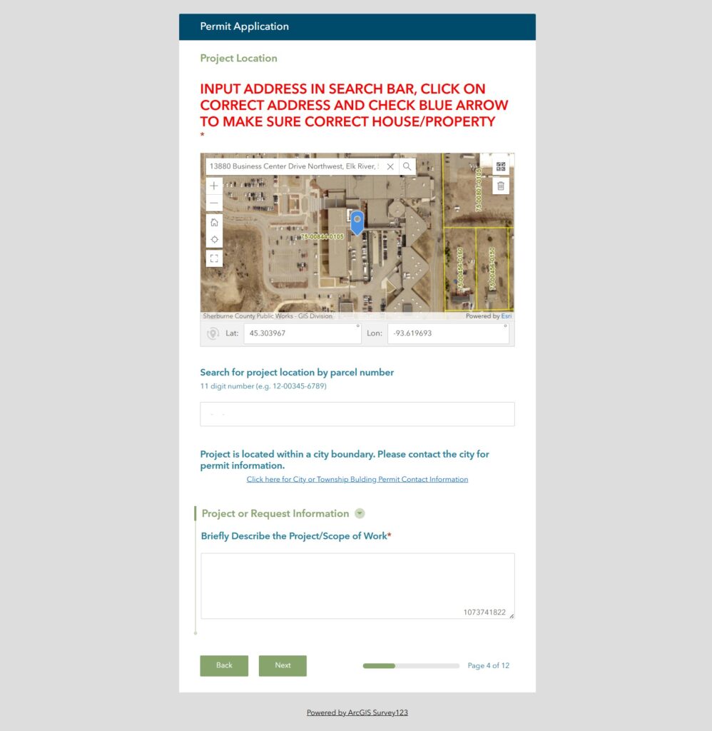
2. Smarter Compliance in the Built Environment
Planning departments are also under pressure to modernize zoning, building, and preservation compliance to protect safety and character while keeping projects moving. For years, NACo, NLC, and APA have highlighted zoning reform, modern code enforcement, and streamlined permitting as key tools for addressing housing and economic development challenges.
ArcGIS gives planners and inspectors a map-centric compliance environment. It links zoning, land use, historic districts, permits, inspections, and violations to location. This allows staff to quickly see where recurring issues occur, prioritize inspections, and support boards and commissions with clear, spatially framed evidence for rezonings, variances, and preservation decisions. Over time, pattern analysis in GIS helps jurisdictions refine standards and processes, reducing uncertainty for applicants while maintaining community expectations.
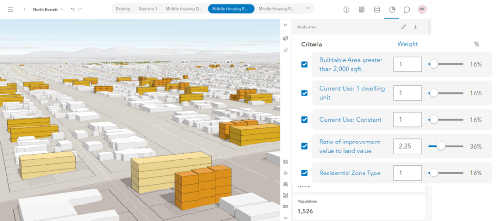
1. Digital Twins, 3D, and Future-Proof Planning
Across planning and developer circles, the need is real for digital twins and 3D tools. These models help communities visualize future outcomes before committing dollars. They can also be used to test build-out capacity, create alternative scenarios, analyze the financial, demographic, and aesthetic impact of developments, and understand infrastructure implications of different developments in a more tangible way. Leveraging digital twins quickly demonstrates the feasibility of a project and speeds the development review process.
With ArcGIS Urban and ArcGIS CityEngine, two key components of ArcGIS as a Planning System, planners can create interactive scenarios that show developers, decision-makers, and residents how proposed changes might affect housing affordability, jobs, transportation performance, and capital needs. This not only strengthens internal analysis; it also provides a clear, visual way to communicate tradeoffs in comprehensive plans, small area plans, and zoning reforms.

GIS is a Cornerstone of Planning
Communities thrive when planners understand community needs and create policies to fulfill them. GIS is the most effective tool for planning professionals to apply their craft and expertise. ArcGIS as a Planning System provides tools for staff and decision makers to create sustainable, inclusive, and thriving communities. By integrating real-time data, advanced analytics, and collaborative environments, ArcGIS builds confidence in the decisions planners make.