In this blog, we consider new ways location intelligence can expand the role of geographic information system (GIS) technology in supporting the full spectrum of human intelligence (HUMINT) activities, from undercover investigations and confidential informant management to information collection, data validation, and operational execution. We are not dismissing the critical need to secure and compartmentalize this sensitive work, those guardrails remain essential. What we are advocating is the integration of complementary information sources, visualized and analyzed alongside HUMINT data, to create a more accurate operational picture. This can and should occur within the same secure IT environment where HUMINT data already resides. The intent is to spark ideas, offering new geospatial concepts that readers can adapt within their existing security protocols to enhance investigations, situational awareness, coordination, and mission success.
Elevating HUMINT with Location Intelligence
HUMINT tradecraft has long been one of the most effective methods for uncovering threats, disrupting criminal networks, and generating actionable insights. Yet despite its inherently spatial nature, tied to people, places, patterns, and movement, it is too often managed outside of that context. The result is fragmented reporting, blind spots, and missed connections. Location intelligence addresses these gaps, bringing human-driven insights into sharper focus and enabling more coordinated, precise, and timely action.
A Geospatial Life Cycle for HUMINT
GIS is more than mapping tools. Applied to HUMINT, GIS enhances the full process enabling better planning, smarter source management, and faster decision-making. A geospatially enabled HUMINT life cycle includes:
- Mission planning—Identify secure meeting sites, assess surveillance infrastructure, and simulate human movement to discreetly design operations.
- Collection—Map potential sources, track their movements, and evaluate proximity to priority targets to support recruitment and tasking.
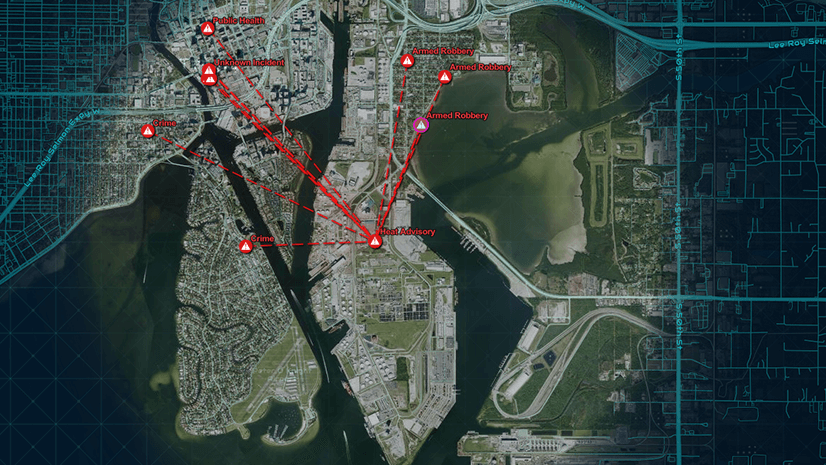
- Validation—Compare reported activity against patterns of life and corroborating data to confirm accuracy and expose deception.
- Analysis—Apply HUMINT tradecraft within a geospatial context to interpret reporting, uncover behavioral trends, and generate actionable insight.
- Dissemination—Deliver interactive maps and dashboards that share intelligence securely and promote collaboration across agencies and partners.
- Decision-making—Provide leaders with multidimensional perspectives, linking time, place, and human factors to inform critical choices.
- Tactical execution—Employ live tracking, imagery, and floor plans to monitor movements, manage risk, and adapt dynamically during sensitive assignments.
- Threat mitigation—Anticipate vulnerabilities and reduce exposure using visibility analysis, terrain modeling, and digital twins.
- Intelligence fusion—Integrate HUMINT with unlimited data sources (traditional intelligence streams, open-source inputs, and nontraditional datasets) within one secure environment to provide the foundation for more comprehensive analysis.
Together, these steps create a disciplined framework that reinforces every phase of the HUMINT process, making it more precise, adaptable, and resilient across environments.
A Critical Use Case: Working with Confidential Informants
Confidential informants (CIs) remain central to some of the most sensitive missions, from dismantling criminal cartels and disrupting gang violence to countering extremist threats. Their value depends on where they can operate effectively, what threats they can illuminate, and how their involvement is managed safely.
Location intelligence strengthens CI management by:
- Building pattern-of-life profiles to understand routines and social connections
- Matching sources to missions where their access provides the greatest value
- Deconflicting overlapping activities across agencies to prevent compromise
- Linking CI reporting with CAD/record management system (RMS) data, tips, or open-source intelligence to reveal broader patterns
This moves informant handling from a reactive activity to a structured element of the HUMINT life cycle that enhances safety, coordination, and mission success.
Why It Matters Now
The intelligence picture will never be complete. But integrating spatial context into HUMINT reduces blind spots, accelerates decision-making, and enables more deliberate action. Whether confronting organized crime in cities, countering extremist activity, or protecting borders, GIS-enabled HUMINT provides the clarity and adaptability today’s missions demand. This technological paradigm shift is about advancing tradecraft, preserving the human element while empowering it with repeatable processes, richer context, and greater precision.
Read the Full Technical Paper
This blog is only an introduction. In our full technical paper, Modernizing HUMINT Tradecraft, we explore the geospatial life cycle in detail, share operational scenarios, and outline practical steps agencies can take to modernize their source management and HUMINT workflows.
To learn more, download the full paper today.