A Customer Spotlight Story
ITC Holdings Corp. is the largest independent electricity transmission company in the United States, operating high-voltage transmission systems that span the Midwest and parts of the Great Plains. Focused on reliability, efficiency, and innovation, ITC owns and operates more than 16,000 circuit miles of transmission lines. The company delivers power to millions of customers by ensuring the grid operates to meet the demands of today, while building the infrastructure needed for tomorrow.
ITC has a strong commitment to safety, sustainability, and stakeholder collaboration. It leverages location-based tools like ArcGIS to manage its infrastructure assets, protect the rights required to operate and maintain that infrastructure safely, and continues to adapt and respond to long-term system needs to enable the new energy economy.
CHALLENGE
Electric transmission infrastructure organizations like ITC rely on property ownership, along with easements and licenses on their transmission right-of-ways. As such, ITC must continually engage with landowners to ensure there are no encroachments that may impede the safe operation and maintenance of the electric transmission infrastructure in the right-of-way.
Regarding real property owned in fee by ITC, this engagement often involves working with landowners who own property adjacent to the right of way to limit their use of the ITC-owned property. ITC needs to map each landowner engagement, record key details, and, when required, create action plans to improve safety and prevent issues that could disrupt critical infrastructure. Spreadsheets and paper notes made it hard to apply a location-based approach and manage encroachments efficiently. Without location references, prioritizing became cumbersome and time-consuming.
SOLUTION
ITC is an organization that continuously engages in process improvements to build efficiencies. As such, ITC turned to ArcGIS to modernize, automate, and improve how it collects encroachment data on its properties. The ITC GIS team deployed ArcGIS Field Maps and ArcGIS Online, equipping right-of-way agents with a mobile-friendly platform that replaced clipboards and pencils with real-time, geo-enabled data collection.
“With ArcGIS Field Maps, much of the process is automated and improved in the quantity and quality of the location-based data we are now collecting.” Fernando Guevara, Senior Real Estate Specialist, ITC Holdings Corp.
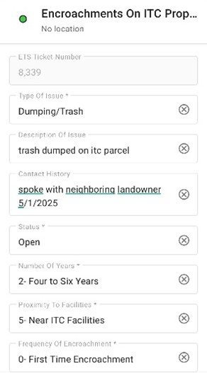
ArcGIS Dashboards was configured to visualize all of the community engagements in one location, accessible to those who need it, when needed. This offered leadership a clear, near-real-time overview and helped field staff prioritize their work based on a holistic understanding of each engagement and the potential issues. The team introduced smart pick lists within ArcGIS Field Maps, replacing free-form text with structured options. This helped streamline the process.
ArcGIS Field Maps automatically captures key information on the nearby infrastructure and land base, such as asset identification numbers and cadastral information from its enterprise GIS.
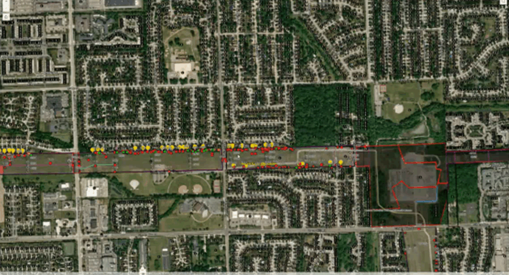
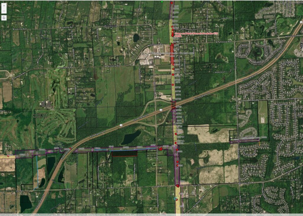
ArcGIS Field Maps pinpointed the location of encroachments.
RESULT
The result of the new process:
- Eliminated manual entry
- Increased accuracy
- Streamlined the process
- Created a highly efficient workflow
- Saved time
- Enhanced data quality
- Reduced cost per encroachment managed
The automated process gave a small staff the power to manage encroachments effectively. By moving to a digital, GIS-driven workflow with ArcGIS Field Maps, ITC can now more efficiently quantify and prioritize potential impacts to its infrastructure. An automated scoring system ranks each interaction, with higher scores showing greater priority for action to protect safe and reliable operations.
Encroachment data collected by mobile workers
Using ArcGIS Dashboards, the team responsible for this work can visualize and sort through each engagement based on urgency, allowing them to focus on the highest priorities first. This data-driven prioritization significantly improved efficiency and work assignment.
A data-quality-first configuration approach enabled within ArcGIS Field Maps ensured consistent and high-quality data. Each user now captures all of the critical information tied to its location.
Additionally, the map-centric design provides a user-friendly experience to look back to understand who, what, and, most importantly, the location of each encroachment. Furthermore, many potential issues and items that are identified require a team approach to resolving, from legal to field agents. ArcGIS plays a critical role in coordinating, communicating, and collaborating activities needed, speeding up decision-making and response to the prioritized work. The solution improved safety and reliability, streamlined operations, and supported ITC’s efforts to manage encroachments confidently.
The encroachment dashboard provides data across the company.
”The manual process was not as efficient as the current process. The field and office personnel in charge of these encroachments knew there was a better way. ESRI’s GIS tools reduced the work required, delivered analytics we didn’t have, and improved our community response time.” Adam Cianfarani, Manager of GIS and Engineering Data, ITC Holdings Corp.
BENEFIT
Implementing the ArcGIS mobile and Dashboard approach delivered benefits across the organization and improved community relations. With an even more proactive, structured approach to tracking and resolving potential issues impacting its infrastructure, ITC has increased its understanding of each encroachment.
Operationally, the solution improved efficiency by reducing the time required to assess and take action. Tasks that previously required repeated field visits can now be performed from the office, thanks to real-time mobile data collection via ArcGIS Field Maps. Data capture improvements, automated timestamps, and geo-enrichment (e.g., nearest structure, parcel ID) ensure high-quality and accurate information.
“Moving from spreadsheets and manual data entry was a game-changer. Productivity increased, resulting in fewer issues and a reduction in costly visits to the field.” Daniel Hutchison, Senior GIS Analyst, ITC Holdings.
Location-based information helped staff and managers rank encroachments by urgency and impact, ensuring efforts focused where they mattered most.
Community engagement around critical infrastructure has improved. Using GIS, staff members work closely with residents, build goodwill, and reach collaborative solutions—like licensing activities—while providing clearer communication in each interaction. The solution provides a clear return in cost savings, risk reduction, efficiency, data integrity, and public trust.
NEXT STEPS
Looking ahead, the utility plans to leverage GeoAI and spatial analysis to visualize the patterns and trends across its entire geographic footprint, helping to identify areas and prioritize and perform the work more effectively. Additionally, the team will leverage tools like ArcGIS GeoEvent Server and ArcGIS Field Maps task feature to automate further workflows, such as sending notifications when new potential issues are found or resolved. This automation will ultimately provide greater visibility to ITC as an organization, when and where it’s needed.
“At ITC, we’re always looking for ways to improve our processes and deliver better outcomes for our customers. The GIS Team, in partnership with Esri’s ArcGIS platform, equipped us with tools that enable data-driven decision-making, reduce costs, and accelerate results for our community partners. It’s a great example of how innovation and collaboration help us deliver power safely, reliably, and affordably.” Jenny D’Anna, Deputy General Counsel – Utility Operations, ITC Holdings

