Customer Spotlight Story
CORE Electric Cooperative traces its roots to 1938, when it was established to bring electric service to rural communities across Colorado with just 23 members and 15 miles of distribution line. Today, CORE has evolved into Colorado’s largest electric distribution cooperative and one of the largest member-owned electric utilities in the United States, serving more than 185,000 members and approximately 400,000 residents across a 5,000-square-mile territory along Colorado’s Front Range. Its service area spans an exceptionally diverse landscape, from the high plains east of Denver to the rugged Rocky Mountains, with elevations ranging from below 5,000 feet to nearly 14,000 feet.
Headquartered in Sedalia, Colorado, CORE delivers reliable, affordable power across a rapidly growing region while maintaining its commitment to local ownership, innovation, and community service. As a not-for-profit cooperative, CORE continually reinvests in infrastructure, technology, and system resilience to meet the evolving energy needs of its members.
Geographic information systems (GIS) have long played a strategic role in CORE’s operational excellence and grid modernization efforts. Over the years, the cooperative has leveraged GIS as the authoritative system of record for its electric network, enabling field crews, engineers, and operations personnel to work from a shared view of critical infrastructure assets.
By integrating location intelligence into daily operations, CORE has improved asset visibility, streamlined maintenance planning, and enhanced situational awareness across its expansive and geographically challenging service territory. GIS has supported initiatives ranging from vegetation management and pole inspection programs to infrastructure hardening and wildfire mitigation efforts
CHALLENGE
CORE’s legacy GIS needed to be upgraded to keep pace with the organization’s transformation. A 64-bit platform, such as ArcGIS Utility Network, Esri’s next-generation Network Information Management System (NIMS), would integrate more effectively with enterprise systems, including the planned advanced distribution management system (ADMS). CORE also sought a highly detailed NIMS data model to support enhanced management of distribution and transmission networks, operations, and outage response.
SOLUTION
Preparing for its GIS data migration, CORE evaluated the Essentials and the Electric Utility Network out-of-the-box data models. It chose to go beyond the models’ base configuration by incorporating fully spatialized units and assemblies into individual network devices. This meant that the position, orientation, and interactive relationships of the electrical components were modeled in sufficient detail to enable the creation of a digital twin.
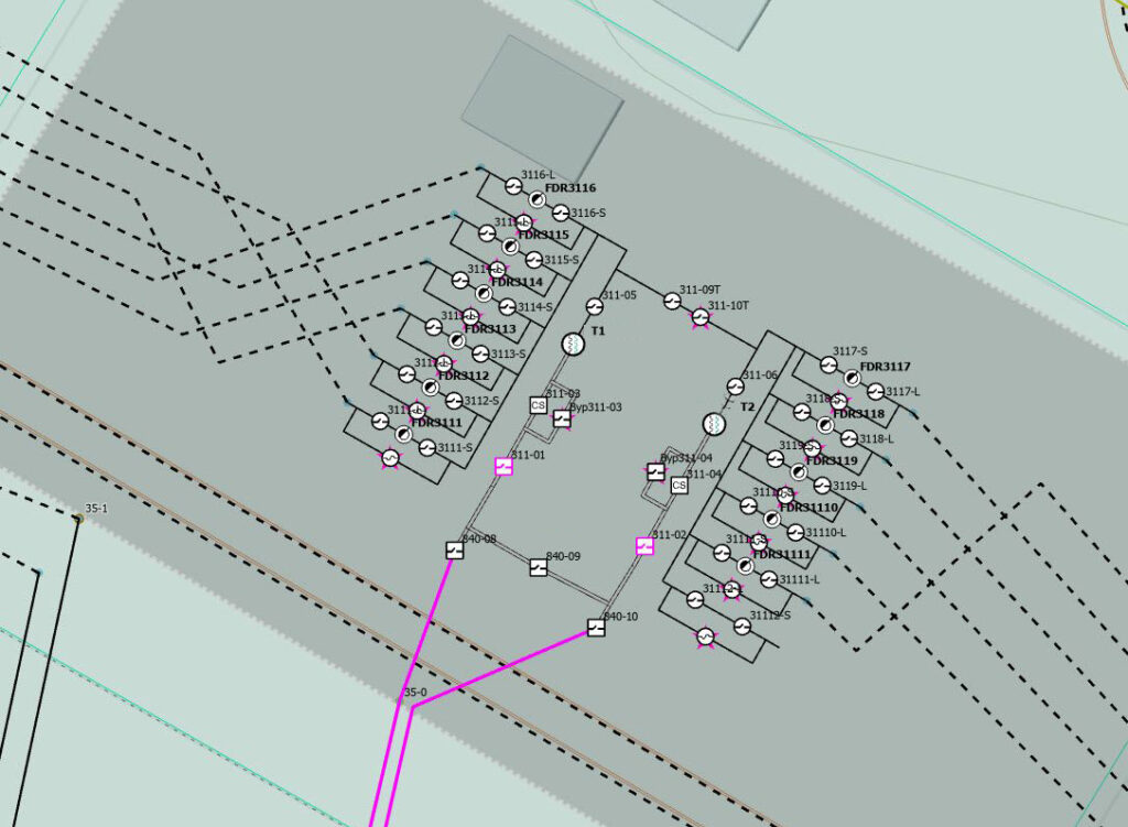
ArcGIS Utility Network models the substation internals.
For CORE, in addition to poles, vaults, and transformers, the model includes components such as capacitors, switches, and regulators. A standardized digital diagram was created for each feature type and imported with custom tools. These tools spatially linked all structures within the new NIMS, ensuring traceability from generation to service, which is key to improved outage management and asset maintenance.
Finally, the project scope expanded to combine electric transmission and distribution in a single NIMS model.
PARTNER
UDC partnered closely with CORE throughout the transformation, bringing deep ArcGIS Utility Network expertise, proven migration tools, and utility industry best practices.
We deeply appreciate UDC’s partnership and knowledge, which were vital to our accomplishment.” – Duane Holt, GIS Manager, CORE
Through collaborative planning, data modeling, system configuration, and network migration services, UDC helped CORE establish a high-fidelity enterprise network model that unified transmission and distribution assets within a single system. This foundation enabled the operational efficiencies, data quality improvements, and future-ready capabilities that position CORE for continued growth and innovation.
RESULTS
Combining CORE’s distribution and transmission services within the NIMS leverages the cooperative’s existing operational support model and avoids costly rework to accommodate future transmission acquisitions. The digital twin data fidelity and spatialized network detail will facilitate a high level of technical capabilities for the cooperative, especially when integrated with the OMS and the impending ADMS implementation. CORE is on track to support its members and their growing needs with a modern approach that enables alternative generation sources, greater reliability, and future innovations.
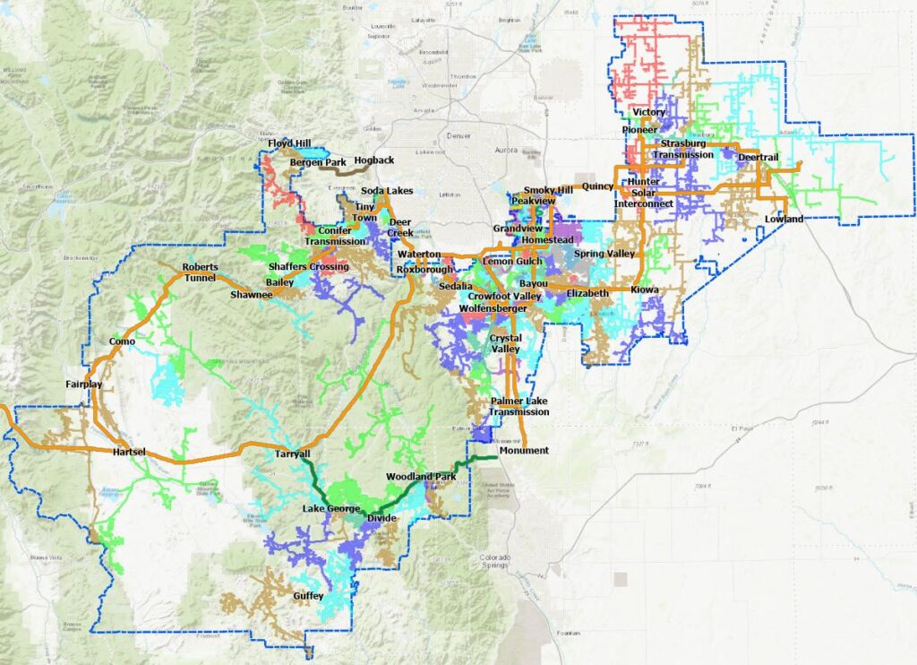
CORE’s network mapping provides visibility into the relationship between transmission and distribution networks.
“We are proud to be one of the first mid-sized electric utility companies to unify transmission and distribution in a single ArcGIS Utility Network that incorporates both spatialized units and equipment assemblies. This achievement represents the realization of our goal for a “high-fidelity” transformation and positions the CORE GIS as a leading platform, prepared for the evolving demands of modern utilities.” – Duane Holt, GIS Manager CORE.
BENEFITS
By consolidating five electric network tiers into a single ArcGIS Utility Network model, CORE established a more efficient and scalable operating environment that reduces maintenance costs, streamlines future system enhancements, and improves regulatory and operational compliance.
“We achieved incredible granularity across asset types, connectivity rules, and terminals, and executed substantial configuration on the UN, which will in turn help fast-track the full realization of a digital twin for CORE.” – Dax Wolfinger, VP UN Transformation UDC
The unified network eliminates duplicate workflows, increases data accuracy, and provides a trusted digital foundation for outage management, advanced distribution management, and future transmission expansion. With a single source of truth for network assets and connectivity, CORE can make operational decisions faster, accelerate project delivery, and support member growth with greater reliability and confidence.
NEXT STEPS
CORE, amid the expansion of its electric distribution infrastructure, is considering a future business model that sources generation from the open market to support its membership growth. This decision would lead CORE to develop and manage transmission assets to connect its distribution network to the new generation sources. The cooperative has completed NIMS implementation, enabling a connected network, and is now transitioning to the next phase of operational systems modernization to support growth and streamline management.
SUMMARY
Challenge: CORE needed to modernize its legacy GIS with a high-fidelity network model capable of supporting enterprise integrations, advanced operations, and future transmission growth
Solution: Implemented a unified ArcGIS Utility Network that combines transmission and distribution assets in a single digital twin, leveraging spatialized units, assemblies, and detailed network connectivity
Results: The new Network Information Management System provides a scalable foundation for outage management, ADMS integration, future transmission expansion, and support for alternative energy sourcing strategies.
Benefits: CORE gained a more efficient, cost-effective, and compliant operating environment with improved data accuracy, streamlined workflows, faster decision-making, and enhanced reliability for its growing member base.