Communities depend on growth to stay vibrant and competitive. Growth requires permitting, and too often, communities are hampered by permitting processes that rely on legacy, paper-based workflows and disconnected databases, creating severe review delays that frustrate developers, contractors, and residents.
There is a Permitting Crisis
Permitting Delays Put Growth at Risk
In a recent RouteFifty article, the $42 billion federal program to expand broadband access is described as being in jeopardy due to the permitting process. The findings are astounding:
- More than half of the 6,000 projects will need 10 permits.
- 76% of the projects require state permits.
- 62% of the projects require municipal permits.
- The typical project engages eight entities, each with a separate process.
- The projects have four years to build.
Projects can end up, “…trapped in overlapping reviews from multiple agencies operating on different timelines with no coordination and no accountability for delay. That is not oversight. It is obstruction by inaction. Death by a thousand paper cuts.”
In response, legislative entities at various levels are discussing solutions to accelerate and simplify the permitting process. It is a major concern for maintaining our national competitiveness. Our communities cannot afford inefficient permitting.
The Challenges Extend Beyond Delays
There are other concerns related to the permitting process. Research shows the most common permitting challenges are:
- Inefficiency: 70% of municipalities report that permitting processes are inefficient.
- Public perception: 62% of the public finds the permitting process overly complex.
- Compliance: $1 million is the average annual fine for compliance failures.
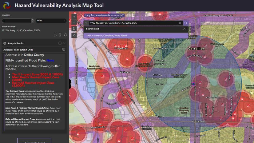
Permitting is a location-based process. A geographic information system (GIS) is the mission-critical enterprise business system designed to turn location information into insight, drive improved decision-making, and deliver significant business value.
It is time for a geographic approach to permitting powered by GIS.
Applying the Geographic Approach to Permitting

GIS enables the geographic approach. The geographic approach is a framework and process that allows us to integrate all the factors, create better understanding, improve collaboration, and enhance solutions to our challenges.
The process starts with data collection, then proceeds through visualization and mapping, analysis and modeling, planning and design, decision-making, and action.
Esri and Trimble, two industry definers and leaders for decades, have partnered to create a truly GIS-centric permitting system that can mitigate our permitting challenges and automate the permitting process.
Trimble Unity Permit provides a geographic approach to permitting in a unified platform. It is built on ArcGIS, the world’s most powerful GIS software, providing a single system with no integration, synchronization, or duplicate data and a real-time view into an enterprise-ready, single source of truth.

Why GIS-Centric Permitting Matters
GIS-centric permitting matters not just because it allows us to use digital maps as a user interface. It also helps us run smarter business operations:
- Manage authoritative permit and asset data in a single environment.
- Connect permits to work orders and inspections.
- Analyze spatial patterns and trends.
- Support holistic capital planning.
- Verify regulatory compliance.
- Enable faster and more defensible decisions.
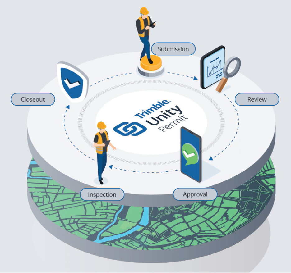
Trimble Unity Permit and ArcGIS enable a paperless permitting process from submission to closeout, driven by GIS.
- ArcGIS provides location context with parcels, assets, rights-of-way, utilities, maps, dashboards, and analysis.
- Trimble Unity Permit runs the workflow with automated routing, ensuring tasks reach reviewers in order.
- Teams get one shared view, allowing better handoffs, faster work, clearer communication, and stronger reporting.
Communities Are Already Transforming Permitting
Permitting agencies across the country are realizing multiple benefits with Trimble Unity Permit and ArcGIS:
- MetroConnects: This wastewater collection provider in fast-growing Greenville County, South Carolina, transformed its obsolete, paper-driven permitting process with Trimble Unity Permit to increase permitting speed and scale.
- Morgantown, WV: The city replaced a fragmented, paper-based process with Trimble Unity Permit, improving visibility across departments, delivering faster access to services, and expanding transparency for residents, businesses, and contractors.
- Racine, Wisconsin: The city streamlined permitting and property assessment workflows by linking permits, assets, and parcel data, supporting more accurate assessments and reducing missed revenue.
Addressing Common Permitting Challenges
Trimble Unity Permit helps accelerate community growth with location-intelligent permitting and addresses top permitting challenges by utilizing a geographic approach:
- Inefficiencies: Streamlined digital workflows improve efficiency, reduce errors, and promote improved decision-making.
- Poor public perception: Stakeholder coordination allows residents, contractors, and others to submit and track applications online through a user-friendly portal.
- Lack of regulatory compliance: Built-in compliance capabilities and reduced liability automatically enforce required steps, apply location-based rules, and create audit-ready records that protect agencies from costly compliance gaps.
See Location-Intelligent Permitting in Action
Please join me and staff from Trimble on Thursday, November 19, 2026, from 1:00 PM to 2:00 PM Eastern to learn how leading agencies use digital public portals, automated routing, and map-driven dashboards to cut inspection turnaround times, save hundreds of labor hours, and establish a single source of truth for future digital twin and artificial intelligence integration.
Start transforming your permitting process now, before you’re forced to.