Dominion Energy Virginia serves over 2.7 million electric customers across a large and topographically diverse service territory. Demand is rising quickly, driven by data center growth and electrification, while severe coastal storms continue to place reliability at risk. Significant sections of the distribution network run through heavily vegetated and hard-to-access areas, making inspection and maintenance both critical and complex.
Over time, Dominion collected large volumes of imagery and inspection data across programs such as vegetation management, overhead circuit patrols, and pole inspections, but held it in separate systems that limited its value across the organization. Core workflows remained manual: Vegetation management followed multiyear trim cycles, asset inspections were limited by field accessibility, and pole assessments relied on manual patrols, making a consistent systemwide view of asset condition difficult to maintain.
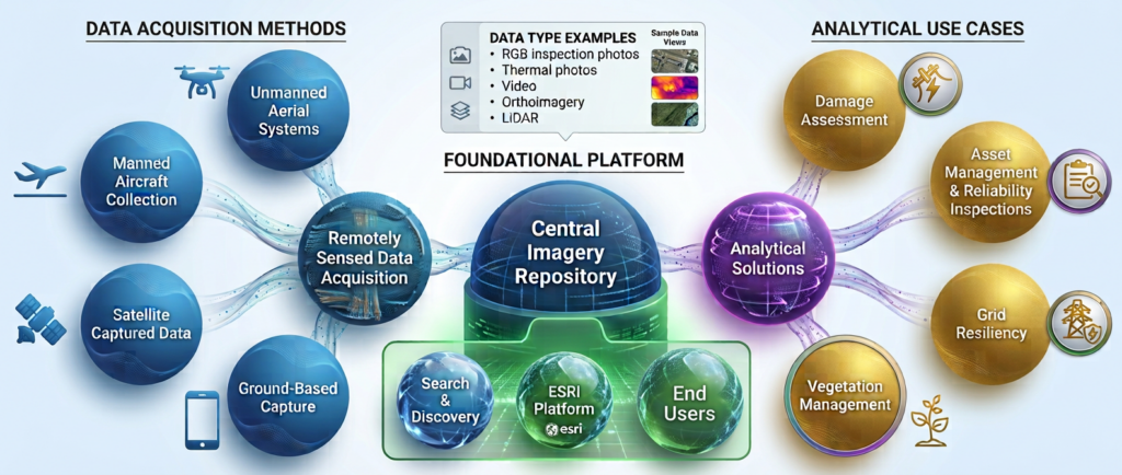
Recognizing these challenges, Dominion launched a remote sensing Image Management and Analytics Program (iMAP) to centralize remotely sensed data and enable advanced analytics across multiple high-value use cases.
The Challenge
Before committing capital to an enterprise imagery platform, Dominion needed three things at once: a business case that would withstand regulatory scrutiny, a set of use cases it could prove inside a pilot window, and an architecture its own security and GIS standards would accept.
- Proving value before committing capital—An enterprise imagery platform is a multiyear investment whose value compounds over time. Asking the regulator to approve a systemwide build-out on projected benefits alone would not have survived scrutiny, particularly with other grid transformation programs in flight where overlapping benefit claims risked undermining all of them.
- No consolidated view of the current state—Imagery, inspection, and vegetation data sat in separate systems, and the workflows, budgets, and dataflows around them had never been documented in one place. Without that baseline, neither the benefit quantification nor the architecture had a defensible starting point.
- More viable use cases than could be proven at once—Remote sensing touched nearly every part of electric distribution, and almost every candidate had a credible owner and a plausible benefit. Narrowing to a provable few was harder than generating them.
- Strict security constraints in a fast-moving vendor market—Asset imagery is classified as Critical Electric Infrastructure Information (CEII), ruling out multi-tenant public-cloud analytics regardless of capability. The collection and analytics market was also fragmented and moving quickly, with few solutions pre-integrated into the ArcGIS and Amazon Web Services (AWS) environments Dominion had standardized on.
The Partner
PwC supported Dominion Energy in developing the business case and implementing its Image Management and Analytics Program (iMAP). Working closely with business, GIS, and IT teams, PwC helped define the program vision, identify high-value use cases, design the platform approach, evaluate vendors, and execute the technology pilots that validated remote sensing and analytics capabilities, alongside program planning, stakeholder alignment, and change management to support adoption.
The Solution
Dominion Energy engaged PwC to build the iMAP business case, shape the platform approach, and support the regulatory filing under Virginia’s Grid Transformation (GT) Plan. Rather than justify a single technology, the program treated remotely sensed imagery as shared infrastructure, collect once, use many times, and built everything else around that premise.
Mobilize and establish the baseline.
Stood up the program structure, sponsors, decision rights, work plan, cadence, and convened a working team spanning Electric Distribution operations and engineering, GIS, and IT and cybersecurity. Documented current-state workflows, program budgets, data flows, and governance and security standards to anchor both the business case and the architecture.
Settle the operating model early.
Assessed centralized, hybrid, and decentralized models against Dominion’s structure and cost profile, then recommended an operating model centralized enough to deliver consistent collection standards and vendor spend efficiency while preserving functional autonomy.
Prioritize use cases through a scoring framework.
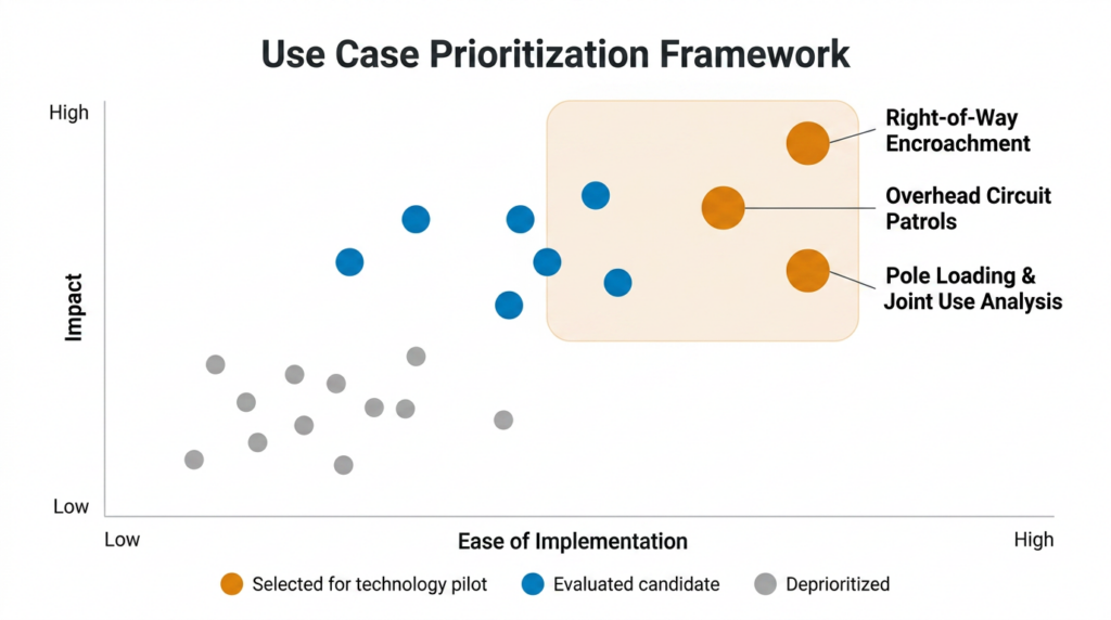
Inventoried candidate use cases through workshops across functional groups, then scored each against impact and implementation effort. Three were selected for pilots, right-of-way encroachment, pole loading and joint use, and overhead circuit patrols, chosen because they span multiple business units, share the same LiDAR and imagery collections, and leave a pipeline for later waves.
Design the foundational platform with GIS at the center.
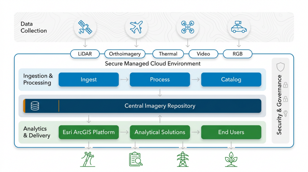
Developed the architecture as a production environment within a Dominion-managed AWS Virtual Private Cloud, governed by four principles: harmonization, Esri integration, security, and scalability. ArcGIS acts as the hub, mapping imagery to structures, giving Electric Distribution a geospatial view of asset condition, and hosting the deep learning models applied to that imagery, all inside Dominion’s environment as required for CEII-classified data.
Evaluate vendors against platform fit.
Evaluated more than ten collection and analytics vendors on service offering, financial stability, compatibility with Esri and AWS, and utility track record, then facilitated capability reviews with Dominion’s technical and business teams. Assessing them against the target architecture rather than in isolation made integration complexity a first-order criterion and yielded a multi-vendor, multi-modality approach.
Build the business case across use cases, not around one.
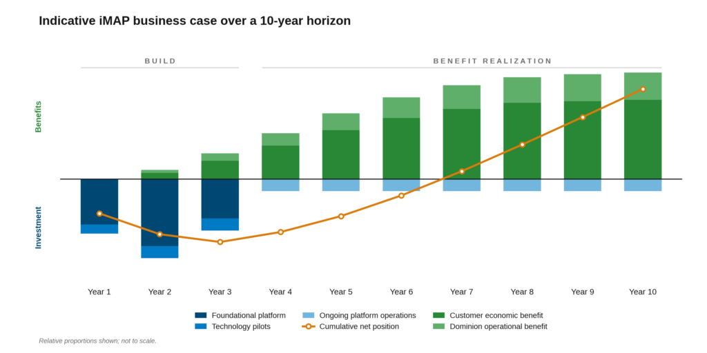
Quantified benefits in two categories, customer economic benefit from avoided outage minutes, and Dominion operational benefits spanning vendor spend, workflow productivity, asset life, and GIS capability, and built costs bottom-up across labor, licensing, hosting, managed services, and data acquisition. Valuing three use cases rather than one made iMAP defensible as an enterprise capability.
Structure the regulatory ask in two parts.
Structured the filing as two components, the foundational platform, and three technology pilots, submitted under Phase IIIB of the GT Plan in March 2025. Virginia’s regulator holds utilities to a prudency standard: spending must be reasonable and benefits real rather than assumed. Splitting the ask met that test, building the platform once and proving value on a defined footprint before seeking approval to scale the program systemwide.
The Results
The Virginia State Corporation Commission approved both components in full under Phase IIIB of the GT Plan (Case No. PUR-2025-00051), authorizing approximately $28 million to build the foundational platform and execute the three technology pilots across 2024 through 2026. In doing so, the Commission recognized the value of a central repository for imagery of Dominion’s distribution assets and of applying advanced remote sensing to drive customer and operational benefits.
The platform then moved from design into build, with PwC supporting implementation. It is being delivered as a governed, cloud-native environment within Dominion’s AWS Virtual Private Cloud with ArcGIS at the center, and is scheduled for production release in Q4 2026.
All three technology pilots are complete and field validation is underway. Early results have identified defects including broken cross arms, leaning poles, line sag, and missing poles, demonstrating the efficacy of the technology across each use case. The analytics also compressed the timeline: Buzz Solutions’ PowerAI platform reviewed over 41,000 images to correctly identify 120 damaged cross arms, completing in hours what manual analysis had taken months to do. Together, the approved filing, the platform in build, and the validated pilot findings give Dominion an evidence base rather than a projection to support its next Grid Transformation filing.
“Dominion took an enterprise imagery and analytics platform through a regulatory approval process without a clear precedent to follow, so the use cases and value had to make the case. The pilots are proving that value now, and there’s a clear path to scale iMAP across the system.” – Jaime Crawford, PwC iMAP Program Lead