A Graduate Student Walks Into…
The graduate student walked to the edge of the booth, looked up at the banners, examined what was going on at the kiosks, and then shook his head.
“Yeah,” he said, “I don’t know why I’d need this. This stuff is for mappers. I’m going to be a planner.”
At the time, I was working for GIS, Inc., an Esri Business Partner. My colleague and I were helping to work the Esri booth at the APA’s National Planning Conference in Seattle in 1999. This soon-to-be-planner’s thoughts were fairly common at the time among planning professionals. GIS required a lot of money, a beefy machine to run, and a couple weeks’ worth of training to get started. In fact, in my first job in planning, there wasn’t another planner using GIS in the entire office…and for those very reasons.
What Happens When We Take a Location Approach?
Over the last twenty years, one of the undeniable trends I’ve watched at the National Planning Conference (and dozens of state APA chapter conferences) is the number of students who not only have GIS as part of their curriculum, but have embraced it as a necessary tool to do the work that’s expected of them. This has led to a new generation of planners that design their communities with GIS. Why is that? It’s not because I’ve gotten better at answering that grad student’s question.
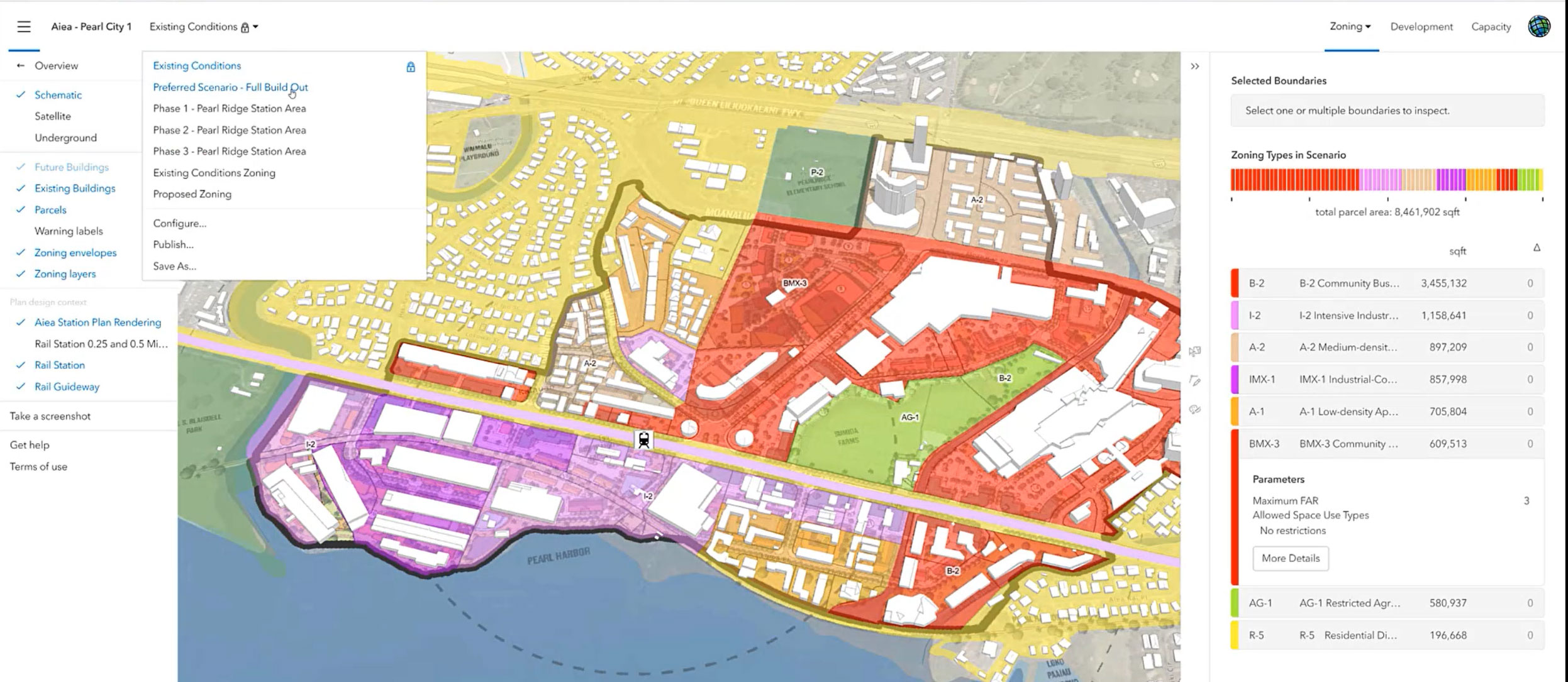
The theories, practices and disciplines of community planning have evolved significantly, particularly in the last few decades. Even as these changes have taken place, one constant has not only remained, but become even more prominent. Location is the common factor that influences how, where and when planners and developers design their communities. Location is also the driver for how citizens and stakeholders react and respond to these designs. Measuring, analyzing, and visualizing location is where GIS shines, and with the new web-based tools available, planning professionals can utilize these geospatial tools without being GIS experts.
Think about this from the standpoint of day-to-day workflows revolving around current planning in communities across the world. This can be in the form of a rezoning, subdivision review, variance, site plan, and so forth. Planners must balance the requests from landowners and developers with the short and long-term needs of the community. Some of these workflows are strictly regulatory (e.g. lot size, setbacks, easements, etc.), while many of the workflows require subjective analysis about the design. GIS adds the element of location into each of these workflows empowering planning departments to automate common processes like public notification and land use inquiries, standardize data collection like code enforcement, and leverage data into applications to visualize, measure, and analyze proposed developments.
Asking Ourselves New Questions Through GIS
One of the most impactful components of using GIS to design communities is how it moves discussions from strictly reactive to proactive. No longer do planners have to sit and wait on a developer to submit a site plan or a subdivision review. Using web apps like ArcGIS Urban, planners can create multiple development scenarios ahead of time and actually work with the property owner or developer to identify designs that meet the characteristics and needs of a neighborhood. You don’t have to have been working in planning long to realize the time and money (and headaches) this approach would save developers, administrators, and your colleagues. In the past, this would have taken an inordinate amount of planning staff time or money to perform through a consultant.
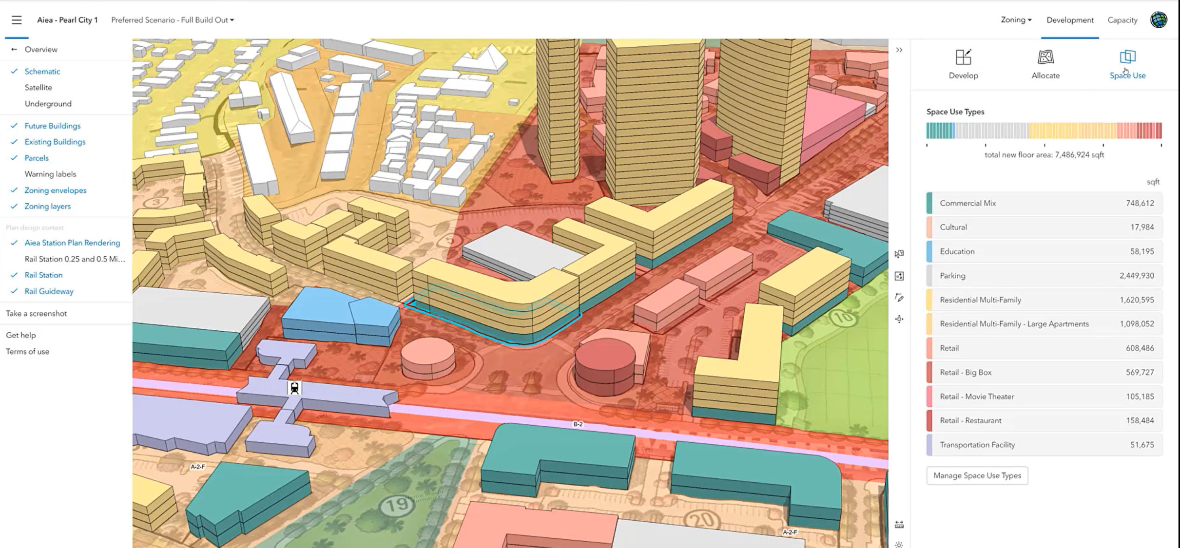
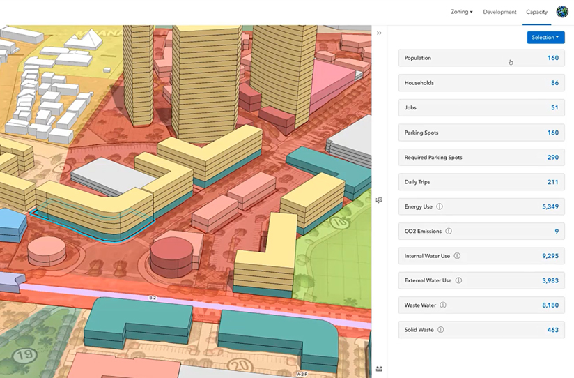
Designing digitally generates a data-driven approach to community development. It becomes less about the planner just saying this is a good idea and becomes more about seeing the metrics for this development. The discussion evolves to not only what it could look like, but how many people will this development house? What’s the impact on impervious surfaces, stormwater, and traffic? How many jobs could this mixed use development create? What’s the tax base impact? All of this can be designed and measured through web-based GIS tools that planners can be up and running on in a fraction of the time that it would have taken 20 years ago.
GIS stopped being a luxury and started becoming a necessity for planning professionals years ago. Now, with the ability to design, analyze, and collaborate over a secure web platform, planners can quickly find the best, most sustainable development path forward in both the short and long term for their community.
Supporting a Monumental Shift for Planners Through Continued Education
Author’s note: I often think about that graduate student and I hope he has shifted his thinking—if he is a planner, he is a mapper.