Salt Lake City Department of Public Utilities (SLCDPU) provides essential services to Salt Lake City and the surrounding areas. The department manages and operates an intricate infrastructure network composed of 1,324 miles of water distribution lines, 679 miles of sewage networks, and 360 miles of stormwater assets. SLCDPU is also responsible for a range of permitting activities, from inspections and planning to community development and capital improvement projects.
SLCDPU undertook an effort to streamline and modernize its permitting process using Trimble solutions and Esri ArcGIS.
Challenge
Salt Lake City is one of the fastest-growing cities in the western US. This rapidly expanding urban area faced a combination of challenges—aging water infrastructure and drought—that placed increased pressure on SLCDPU to maintain systems effectively. To provide more efficient service to contractors and residents, SLCDPU needed to digitize its previously paper-based permitting and community development workflows.
A geographic information system (GIS)-centric organization, SLCDPU has been using ArcGIS since 1989, often applying it to visualize historical work order data. “Having all this information digitized and put into GIS allows us to gain a comprehensive understanding of our public assets, providing data-driven insights that shape our operations and maintenance activities,” said Tammy Wambeam, GIS/IT administrator for SLCDPU.
However, tasks such as tracking projects and managing permits and schedules remained challenging. “Identifying the responsible inspector or engineer for specific projects was difficult, and we often lacked clarity on the project phases,” Wambeam said, “leading to time wasted in sifting through documents or making numerous phone calls to find project information.”
Partner
Trimble is a global leader in technology solutions for various industries, including water, construction, agriculture, and transportation. Since 1998, Trimble Cityworks AMS has served as SLCDPU’s GIS-centric enterprise asset management system.
Solution
SLCDPU decided to implement Trimble Cityworks PLL to centralize the organization’s data and improve permitting workflows. Before implementing Cityworks PLL, SLCDPU’s work order data was separate from the organization’s permitting data, leading to fragmented information across multiple systems and paper trails—resulting in data silos and communication gaps. The disjointed process made it difficult to track permitting workflows and oversee projects from start to finish.
“We needed a permitting solution that could centralize all of our data and seamlessly bring together the Trimble and Esri solutions that we were already using.”—Tammy Wambeam, GIS/IT Administrator, SLCDPU
By adopting Trimble’s permitting solution, SLCDPU was able to digitize its permitting, licensing, inspection, and plan review processes. The organization now uses the solution in conjunction with ArcGIS to manage permitting activities for utility construction related to new developments, site development, subdivisions, new residences, residential remodels, demolitions, fire flows, dry utilities, and more. Additionally, SLCDPU tracks capital improvement projects and infrastructure permitting activities, such as installing new water services, constructing sewer lines and laterals, repairing sewer and water lines, and managing right-of-way permits.

Results
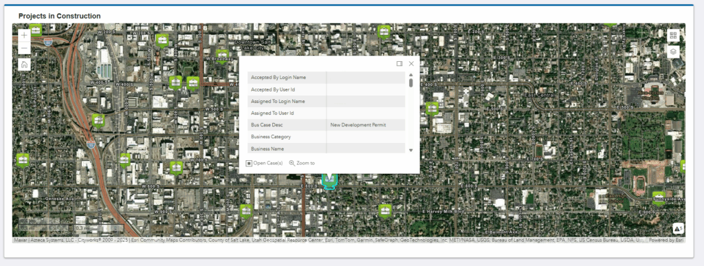
The combination of ArcGIS and Trimble Cityworks AMS and PLL tools allows SLCDPU to consolidate previously siloed permitting and asset management data and workflows into a single, cohesive system. Now, SLCDPU teams can easily access permitting, inspection, work order, GIS, and product data without having to work out of separate systems. Additionally, all of the organization’s public assets and permits are now in a searchable format. Field crews can attach specific information, including photos, comments, and related files, when interacting with the system.
Shifting to a digitized permitting and asset management solution has enhanced SLCDPU’s departmental visibility, streamlined permitting and capital improvement workflows, and enabled the visualization and tracking of assets and work activities through GIS-centric maps. Since implementing Trimble Cityworks AMS and PLL, SLCDPU has seen between 20 and 30 minutes saved per project on the organization’s certificate of occupancy process. With 30–40 projects per month, those minutes add up to 10–20 hours per month of saved time.
The savings extend beyond hours of office labor, with contractors now using an online customer portal. There are now 900 external users, and each form submitted now takes approximately 10 minutes or less to process. And with a paperless work order system in the process of being implemented, paper usage in the office is now down 50 percent.
“The seamless integration between ArcGIS and Trimble has significantly increased our efficiency, enhanced our visibility of work activities, and streamlined our asset management and permitting workflows.”—Tammy Wambeam, GIS/IT Administrator, SLCDPU
In addition, SLCDPU has created customized templates and workflows through automation. For example, when a user selects a task in the workflow, the system automatically generates an inspection and survey work order attached to a feature on the map and relates it to the case document. Since implementing the solution, SLCDPU’s development services team has created more than 1,700 cases that span a variety of permit types. Between automated workflows, dynamic dashboards, and interactive GIS maps that can easily be shared, SLCDPU teams can quickly visualize data and use those insights to inform scheduling, balance workloads, and make hiring decisions.
Leveraging Trimble solutions alongside Esri’s GIS tools helped SLCDPU create an end-to-end connected data environment and a comprehensive system of record that supports a proactive, cost-saving approach to managing assets across the entire life cycle, from permitting and construction to ongoing operation and maintenance. These solutions have improved efficiency and increased transparency.
“SLCDPU now has the tools necessary to perform a more comprehensive data analysis that helps boost our productivity and continue to streamline our workflows.”—Tammy Wambeam, GIS/IT Administrator, SLCDPU
Stay Connected with Esri’s Water Team
ArcGIS is an extensive information system that enables modernization of workflows with easy-to-use applications. Strengthen your organization with GIS-based solutions that will increase efficiency and provide insight for decision-makers. Visit the Esri Water Utilities web site for more information.
Join the Water Utilities Community
Follow #EsriWater on social media: X | LinkedIn
Subscribe to the Water Industry newsletter “Esri News for Water Utilities and Water Resources“