Highlights from the 2025 Esri User Conference (UC) Focus Group Workshop
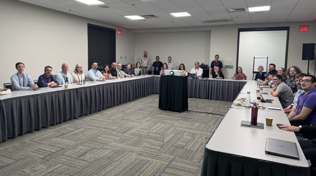
On July 17, 2025, during the Esri UC held in San Diego, California, the Environmental Consulting Geospatial Focus Group Workshop brought together 25 professionals from both large and small multidisciplinary Architecture, Engineering, and Construction (AEC) firms, as well as specialized environmental consulting firms.
Setting the Stage: Our Shared Mission
The environmental GIS professionals representing different engineering and environmental companies participated in a collaborative focus group workshop with one aim in mind:
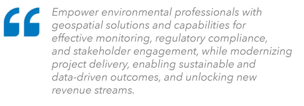
This mission set the basis for the purpose of the workshop:
- Explore forming a geospatial community of practice in environmental consulting.
- Discuss industry trends, challenges, and opportunities.
- Share real-world strategies and success stories.
- Communicate needs to Esri for better product support.
- Foster peer-to-peer learning and professional growth.
The tone was both pragmatic and optimistic—participants weren’t just talking about technology; they were crafting a more interconnected, capable, and forward-thinking discipline.
A Collaborative Format with Purpose
The workshop was designed for maximum interaction. Attendees split into three facilitated working groups and rotated through challenge statement discussions. Each group was given a statement and then asked to discuss how true or false it is for their organizations, projects, and clients. They synthesized key insights, capturing both consensus and points of divergence. A closing survey rounded out the discussion with individual reflections.
This format fostered candid exchanges—where governance aches yielded creative new workarounds, worries about embracing AI blended with excitement, and the collective vision for GIS in environmental consulting took clearer shape.
Key Insights from the Challenge Discussions
Challenge Statement 1: Strategy and Governance
“Geospatial strategy and governance are widely implemented and followed by all users of ArcGIS.”
Takeaway: Strategy and governance represent a journey that requires cultural alignment, clear communication, and sustained leadership support, rather than merely documented rules. Geospatial excellence is achieved through aligned leadership, effective governance, robust technology, organizational collaboration, and empowered talent.
What’s Working
- Formal steering committees and technical practices standardize workflows.
- Enterprise governance frameworks and standard operating procedures (SOPs) guide large teams.
- Smaller firms leverage close leadership ties and mandatory GIS training.
Persistent Challenges
- Mergers introduce conflicting standards and legacy systems.
- Inconsistent adherence, especially by casual GIS users.
- Governance enforcement varies across departments.
Opportunities Ahead
- Create lighter, adaptable strategy and governance frameworks.
- Encourage cross-department collaboration between GIS, IT, and business units.
- Expand accessible training for all levels of GIS users.
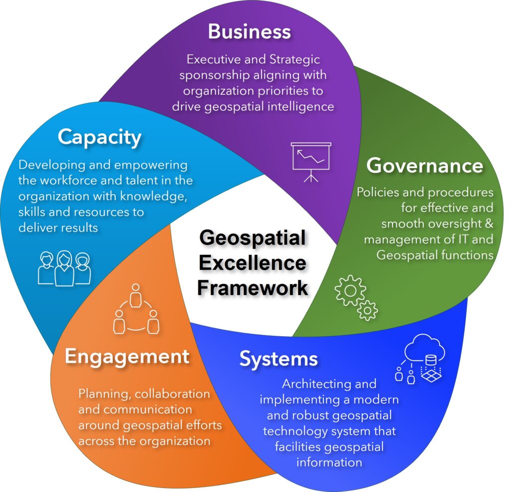
Esri has created a framework that provides a structured, programmatic approach to implementing and maintaining a successful and sustainable geospatial program, considering and navigating the five areas of excellence where our customers have achieved the most success (See Geospatial Excellence Framework below).
Challenge Statement 2: Broadening GIS Engagement
“Non-GIS professionals (scientists, engineers, and project managers) understand the value of GIS and leverage it regularly.”
Takeaway: Visibility, learning, and measurable impact are the keys to making GIS a standard tool across environmental disciplines.
What’s Working
- Interactive dashboards and field apps resonate with project managers and clients.
- Younger, tech-literate staff embrace GIS tools.
- Targeted training, in-house demonstrations, and tools like Field Maps are driving adoption.
What’s Holding Us Back
- Persistent misconceptions that GIS equals “just mapping.”
- Missed opportunities from late GIS engagement in projects.
- Licensing costs and unclear return on investment (ROI) hold back adoption.
Opportunities Ahead
- Build elevator-pitch-ready value statements for executives.
- Position GIS as a profit driver, not a cost center.
- Integrate GIS into the project kickoff stage to shape scope and innovation from day one.
Challenge Statement 3: Artificial Intelligence (AI) in Environmental Consulting
“AI, Machine Learning (ML), and Large Language Models (LLMs) will not impact my environmental workflows and project work.”
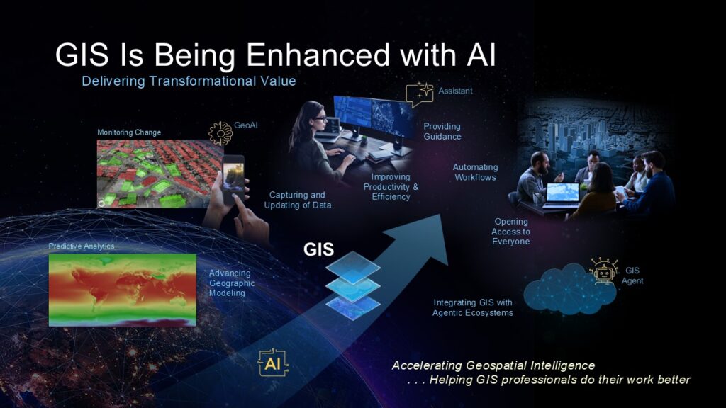
Takeaway: The overall perception is that AI/ML/LLMs are already revolutionizing environmental workflows and project work. AI is not some distant disruptor—rather, it already exists. It will thrive with strategic integration, governance, and staff training.
Current Use Cases
- Automating reports, proposals, and document reviews.
- Enhancing imagery classification and feature extraction.
- Freeing staff from repetitive work to focus on higher-value analysis.
- Real-time safety compliance monitoring via computer vision.
Concerns
- Data security and governance must keep pace.
- Risk of overreliance on AI by less experienced employees.
- The overall perception is that AI/ML/LLMs are already revolutionizing environmental workflows and project work.
Opportunities Ahead
- Embed AI agents into ArcGIS and business tools.
- Train AI models on internal templates and standards.
- Use a “trust, but verify” approach to AI outputs.
- Incorporate Generative AI to expedite tasks that are data-intensive, repetitive, or require frequent communication.
User Conference Survey Insights
Following the workshop, a post-event survey highlighted both excitement and friction points in the current GIS landscape.
Elevating GIS Across Organizations
Participants identified clear steps to embed GIS deeper into their organizations. Most involve education, sponsorship, and ease of access:
- Speed up licensing and client access.
- Transition from static deliverables to interactive web experiences.
- Secure leadership buy-in with concise, outcome-focused narratives.
- Upskill junior staff to widen GIS capacity.
- Implement centralized and collaborative GIS strategies that support key organizational priorities.
- Integrate AI responsibly within secure environments.
- Expand visualization tools and accessibility across teams.
Looking Ahead: A Community in Motion
The message from the workshop was unmistakable: Environmental consulting is rapidly evolving, and GIS is leading the way.
The road forward is:
- Building an environmental industry-focused geospatial community.
- Sharing success stories and lessons learned.
- Giving GIS a proactive leadership role in project strategy.
- Ensuring all staff—not just GIS specialists—can engage meaningfully with spatial technology.
- Working together with Esri to co-create tools and approaches tailored to environmental consulting needs.
Conclusion
The workshop revealed both progress and ongoing challenges in geospatial strategy, adoption of GIS by non-GIS professionals, and integration of AI/ML technologies. Key opportunities include further standardization, targeted training, strategic communication of GIS value, and responsible adoption of AI to augment—not replace—professional expertise. Continued focus on executive engagement, community of practice, and flexible governance will be essential for maximizing the benefits of GIS and emerging technologies across organizations.
For environmental GIS professionals, this workshop was a reminder: You are part of a revitalized environmental geospatial community. Your challenges are shared, your successes are celebrated, and your work is shaping the future of the industry.
Learn how GIS technology empowers consultants to analyze environmental data, assess impacts, and deliver sustainable, data-driven solutions for clients across industries, visit the GIS for Environmental Consulting StoryMap