Customer Spotlight Story
Elnetselskabet N1 is the largest electricity network operator in Jutland, Denmark, employing around 800 people and delivering power to approximately 800,000 homes and businesses every day. The company consistently invests in its grid to ensure high reliability and future readiness for evolving energy demands. In 2026, N1 will invest approximately DKK 2 billion in the electricity grid, marking a record-level investment. In 2025, their customers experienced an average outage time of less than 15 minutes, making it one of the most reliable electricity suppliers in the world.
CHALLENGE
In November of 2023, Denmark experienced one of its most severe storm surges on record. To reduce risk, N1 needed a way to precisely identify which network assets were at risk of inundation and act before the flooding reached critical levels. Traditional monitoring tools alone couldn’t provide the real-time spatial insights needed to proactively manage this threat.
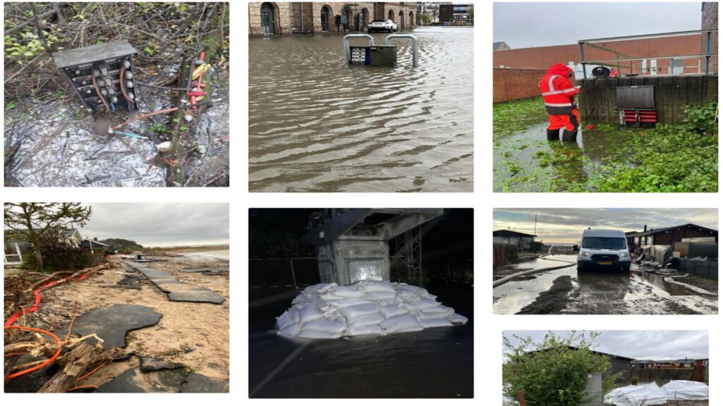
The November 2023 storm surge created havoc along the Jutland coast.
Before and during the storm surge, N1 had many technicians in the area who, before the analysis tool was developed, drove around and physically inspected the installations. This time-consuming process could result in extended customer outage.
SOLUTION
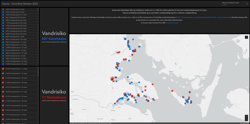
Working with GIS partner and Esri Distributor Geoinfo A/S, N1 developed a data-driven situational awareness and response tool using ArcGIS in less than 24 hours. The solution integrated hydrological flood-risk maps showing potential inundation areas at various water levels (publicly available datasets). The GIS team also leveraged ArcGIS Utility Network and asset data, which contains the locations of all cable cabinets, transformer stations, and grid equipment. Finally, they crafted a custom dashboard and analytics workflow that visualized risk exposure in real time for N1’s control center.
ArcGIS Dashboards was a key tool for analyzing storm-surge-damaged assets.
By combining multiple spatial layers, the tool continuously evaluated how rising water levels would affect specific network assets and displayed the results in an intuitive ArcGIS interface.
N1 has invested in building a comprehensive, highly accurate GIS over many years, with data quality a longstanding strategic priority. This commitment meant that when the severe storm surge hit, their GIS environment already provided a robust and dependable foundation for advanced analytics. ArcGIS applications and datasets are embedded throughout N1’s daily operations, supporting everything from planning and engineering calculations to real‑time operational processes. Because their GIS data is consistently maintained and trusted across the organization, they were able to deliver precise, actionable insights at a critical moment.

N1 is one of Denmark’s largest utilities, operating largely in Western Denmark.
While the full solution was developed in under 24 hours, most of the effort went into downloading high‑volume raster data from ‘Datafordeleren,’ Denmark’s national geodata distribution platform, and preparing a sufficiently powerful environment for processing. With the data ready, the initial ArcGIS Dashboard was assembled in less than an hour.
RESULTS
The solution indicates which areas are at risk of flooding at different water levels using ArcGIS, which contains location data for N1’s entire network of cables, as well as all cable cabinets and transformer stations. Therefore, N1 could continuously predict which locations and equipment were at risk of flooding and preemptively disconnect the equipment before the water masses reached a critical level. N1 proactively de-energized 410 cable cabinets based on forecasted risk. Only 15 of those shutdowns were due to actual inundation issues, meaning the majority were correctly predicted. Just 3,000 of approximately 800,000 customers experienced power outages, and most had service restored within a day. Financial and reputational risk was dramatically reduced thanks to real-time spatial decision support.
“The new analysis tool has proven invaluable in our preventive efforts, enabling us to strategically deploy technicians for patrols and perform network disconnections during the storm surge. As a result, the number of customers affected by power outages was minimized, and the subsequent restoration work turned out to be far less extensive than anticipated.” – Mads Norsted Sørensen, Senior Manager in N1’s Operations Center.
This performance exceeded expectations and demonstrated the power of GIS for dynamic risk prediction in critical infrastructure operations.
PARTNER
Geoinfo A/S, N1’s GIS software and consulting partner, worked closely with N1 to quickly design, build, and deploy the ArcGIS-based analytics solution. Geoinfo contributed its expertise in integrating spatial datasets, configuring hydrological modeling data, and aligning utility network operations to create a real-time dashboard tailored for emergency response. They also supported the technical preparation and ensured the system met N1’s operational needs during the storm surge crisis.
BENEFITS
What took the longest was retrieving the hydrological data and structuring it. Once that was done, the team quickly created a user-friendly dashboard in ArcGIS that the control room used to manage the restoration effort. Instead of manual, time-consuming, and certainly error-prone comparisons across data sources, N1 could follow developments on geographical maps and accurately predict which installations needed to be disconnected, and either carry out the disconnection or switchover centrally, or send a technician specifically to the task.
Benefits included:
- Proactive Risk Management: operators could anticipate flood impacts hours before they occurred.
- Reduced Asset Damage: strategic preventive disconnections kept costly failures to a minimum.
- Operational Efficiency: a simple, intuitive dashboard replaced manual analysis.
- Customer Reliability: outages were limited, and recovery times were short.
- Transferability: other utilities have since expressed interest in adopting the solution.
NEXT STEPS
N1 is exploring ways to enhance and expand the GIS-based tool for broader emergency planning and climate risk adaptation. This includes refining integration with live hydrological forecasts and extending analytics to other climate-driven risk scenarios, such as storm wind damage and heat events.
SUMMARY
Challenge: During the historic November 2023 storm surge in Denmark, N1 needed a faster and more precise way to identify which electricity network assets were at risk of flooding and prevent prolonged outages caused by manual inspections.
Solution: N1 and Geoinfo A/S rapidly built a GIS-based situational awareness tool using ArcGIS that integrated flood-risk maps, utility network asset data, and a real-time dashboard to predict which installations would be affected by rising water levels.
Results: Using the system, N1 proactively disconnected 410 cable cabinets before flooding occurred, limiting outages to only 3,000 of approximately 800,000 customers and enabling most service to be restored within a day.
Benefits: The GIS-driven approach improved proactive risk management, reduced equipment damage, streamlined operations through a simple dashboard, and strengthened grid reliability during extreme weather events.

