Customer Spotlight Story
Established in 1933 to bring reliable electricity to rural communities along Oregon’s northern coast, Tillamook People’s Utility District has supported the economic development and quality of life in Tillamook County for nearly a century. Headquartered in Tillamook, Oregon, approximately 75 miles west of Portland, Tillamook PUD serves about 23,000 customers. Its service territory includes rugged coastal terrain, forests, rivers, and communities exposed to severe weather conditions. Throughout its history, Tillamook PUD has remained focused on affordability, reliability, community accountability, and long-term stewardship while continuing to modernize infrastructure to support the evolving needs of the communities it serves.
A key component of Tillamook PUD’s long-term operational strategy has been its extensive use of Geographic Information Systems (GIS) to support infrastructure management, system planning, and emergency response. GIS technologies help the utility manage electrical distribution assets, coordinate maintenance activities, support vegetation management programs, and improve visibility across its service territory.
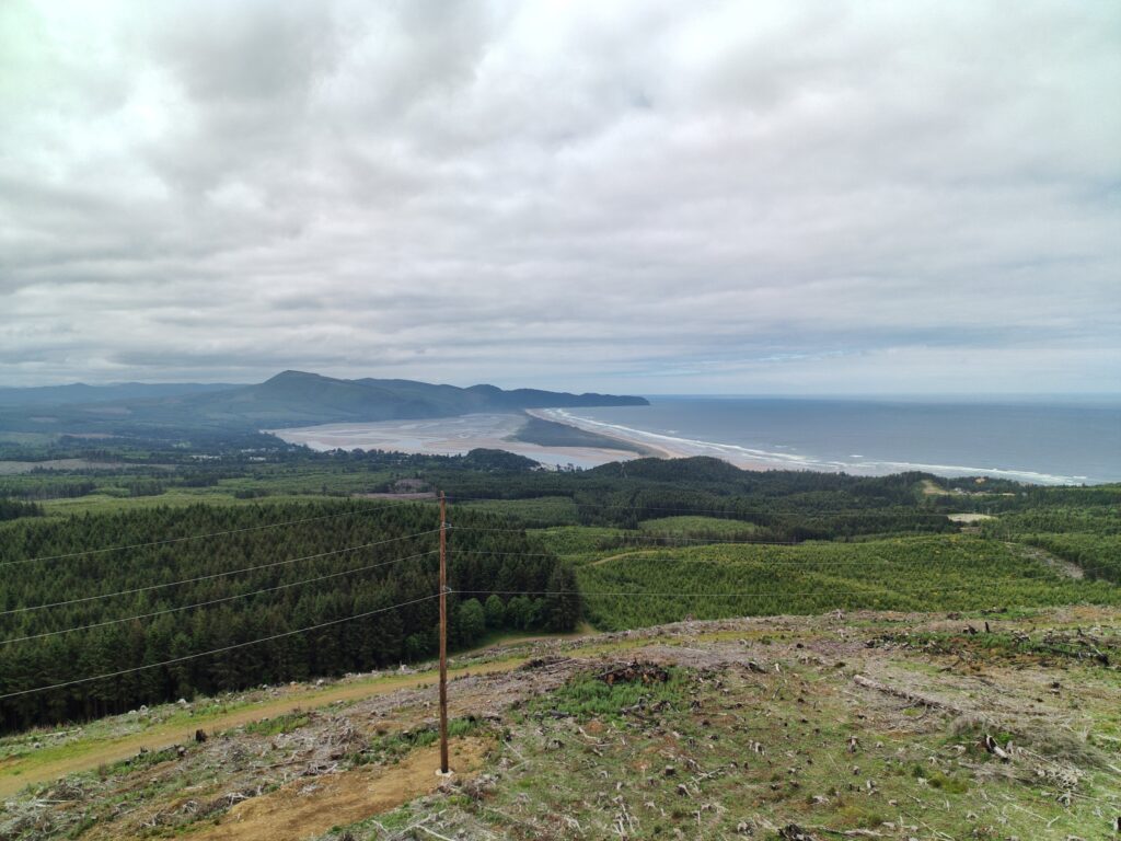
Aerial photo of Oceanside transmission line with a view of Netarts Bay by Ethan Miller, Tillamook PUD.
CHALLENGE
Tillamook PUD faced significant operational inefficiencies caused by fragmented systems and manual processes. Office staff relied on disconnected tools, including Outlook reminders, spreadsheets, and multiple systems that lacked integration. Existing off-the-shelf systems did not fully support the organization’s workflows, especially the more involved customer equipment issues, which require follow-up letters, reminders, and deadlines. These disconnected processes slowed coordination between the field and office and made it harder to track issues through to completion.
A further challenge was ensuring reliable offline mobile workflows for the field inspector. Working in remote coastal and forested service areas where cellular coverage may be unavailable, the inspector lacked reliable offline capabilities to document customer equipment concerns, maintenance activities, safety violations, and vegetation issues. This made it difficult to maintain coordination among engineering, operations, vegetation crews, and supervisors. Compliance reporting tied to Oregon Public Utility Commission (PUC) requirements added to the burden, demanding extensive manual documentation, tracking, and repetitive administrative work. Leadership recognized that the organization needed a more integrated solution to improve visibility, automate workflows, and streamline issue management across departments.
SOLUTION
To address these challenges, Tillamook PUD designed and developed the Issue Management System, a custom web application, over a six- to seven-month period. The system integrated ArcGIS Online and ArcGIS Field Maps with related tables into a unified operational platform. The application includes an interactive web map built with the ArcGIS Maps SDK for JavaScript, where staff can filter issues and see them color-coded by type, status, or assignment, open full details and history, and act on them directly. It also connects to the utility’s existing engineering and service order systems. The system organizes issues into four primary categories: customer equipment, maintenance, safety violations, and vegetation management. Using an advanced configuration of ArcGIS Field Maps, the field inspector can capture issues offline, document inspection details, attach photos, and route assignments directly to engineering, operations, or vegetation management teams. Mobile map areas and feature templates are preconfigured in Field Maps Designer, so staff use standardized offline datasets in remote areas and can quickly capture recurring issue types in the field. As issues are identified in the field, integrations built with the ArcGIS API for Python automatically synchronize the information into the centralized web application, where staff review assignments, monitor status, manage workflows, and track issue completion across departments. The application also allows the field inspector to update infrastructure information, verify attachments, and maintain detailed records tied to utility assets and locations.
“The feature templates save me a lot of time. For the issues I document over and over, I can capture a complete, consistent record in the field in just a few taps.” – Lucy Schiminesky, Field Inspector at Tillamook PUD
The utility also automated many compliance-related workflows that previously required extensive manual tracking. The system automatically generates reminders and deadlines based on letter types and regulatory requirements, eliminating the need for staff to manually calculate future dates or create Outlook reminders. Engineering coordinators can now process large volumes of compliance communications far more efficiently through standardized workflows and automated notifications.
“Our teams now have far greater visibility into operational workflows and infrastructure issues across the organization. The platform has streamlined communication between the field and office while helping us manage compliance and operational work much more efficiently.” – Crissa Alexander, Utility Asset Supervisor at Tillamook PUD
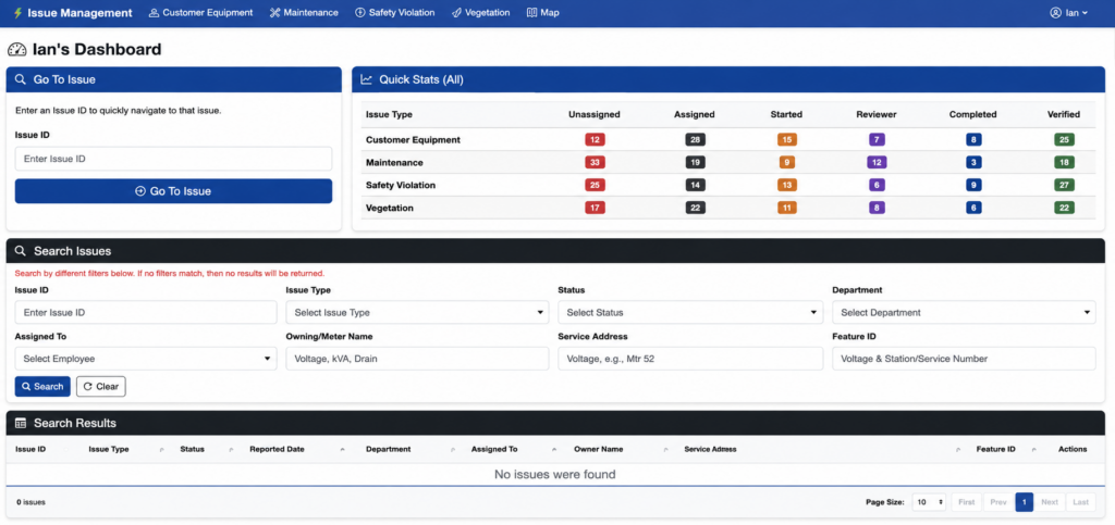
The Issue Management web application captures and summarizes issues.
RESULTS
The new Issue Management System significantly improved operational coordination and visibility across the organization. Automated reminders and notification tracking replaced the manual, Outlook-based processes that engineering teams had previously used for compliance tracking, deadline management, and customer communication, helping staff manage issue lifecycles more consistently and efficiently.
“The effectiveness of the new workflows became clear when engineering coordinators were able to process around 30 compliance-related letters in a single day using the automated system, which auto-populates most of the letter details, a task that previously required substantial manual effort.” – Ian Broad, Senior Developer/Analyst at Tillamook PUD
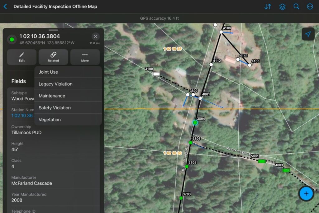
The Field Inspector captures issues using ArcGIS Field Maps.
The platform also centralized issue tracking, field documentation, and workflow management into a single operational environment accessible by engineering, operations, vegetation management, and supervisory teams. Supervisors gained real-time visibility into work status, issue completion, and outstanding activities across departments. The field inspector identifies and routes issues through mobile GIS workflows, and the responsible engineering, operations, or vegetation team completes the work. Many issues, especially the operational repairs a service technician can handle, are corrected within days, closing the loop between identification and repair.
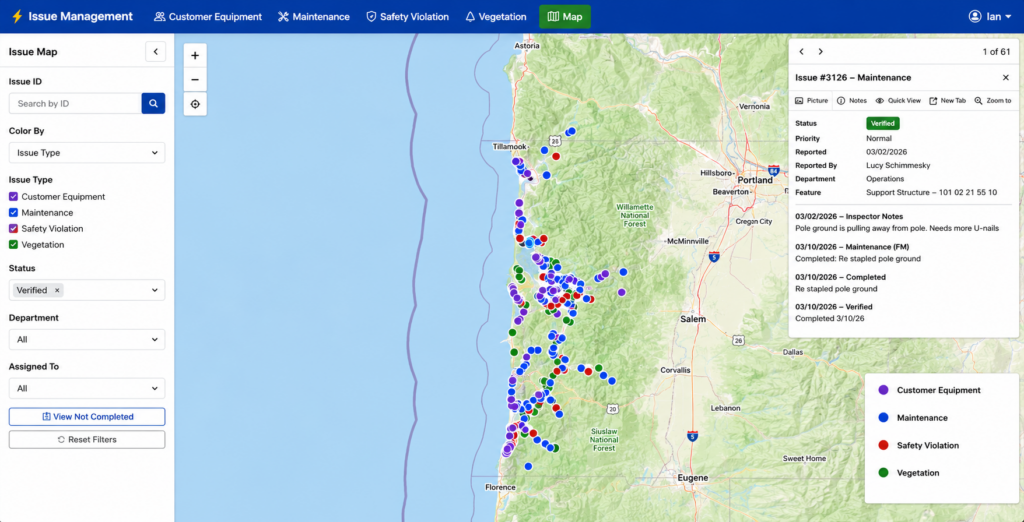
Issues are filterable and color-coded by type, status, or assignment on the interactive web map.
BENEFITS
By centralizing workflows and automating issue management processes, Tillamook PUD improved operational efficiency, strengthened compliance reporting capabilities, and enhanced transparency across the organization. Standardized documentation, before-and-after imagery, and detailed issue histories tied directly to GIS assets improved audit readiness and supported more effective regulatory reporting for Oregon PUC requirements. The platform also improved communication between field crews, engineering staff, and operations teams while reducing the administrative burden of manual tracking and repetitive workflows. Better visibility into inspections, maintenance activities, and corrective actions helped support more informed operational decision-making and long-term infrastructure management.
“What excites me most is how quickly this system has improved day-to-day work for our teams. We’re not just tracking issues better, we are closing them faster, communicating more clearly, and giving staff the tools they need to do their jobs efficiently, even in the most remote parts of our service territory.” – John Luquette, IT Manager at Tillamook PUD
The system strengthens the documentation and resolution of field safety issues, improves the quality and consistency of records, and drives efficiency through automation, without trading one priority for another.
Other utilities across Oregon have expressed strong interest in similar capabilities because many organizations continue to face comparable operational and compliance challenges without flexible, GIS-centered solutions available off the shelf.
TEAMWORK
The initiative was led internally through close collaboration between IT/GIS staff, engineering staff, field operations personnel, and vegetation management teams. Tillamook PUD used Esri GIS technology, including ArcGIS Field Maps, alongside custom web development, to build a solution tailored specifically to the organization’s operational and regulatory requirements. Development involved iterative collaboration sessions with staff and end users, allowing workflows and application features to evolve based on operational feedback and real-world use cases.
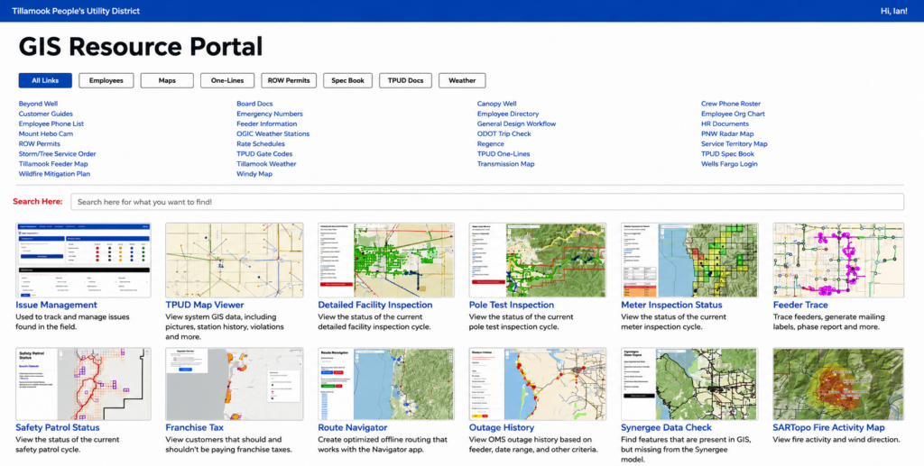
TPUD’s internal GIS Resource Portal facilitates teamwork and transparency.
NEXT STEPS
Tillamook PUD plans to continue expanding and refining the platform as operational needs evolve. Future efforts include enhancing joint-use management workflows, increasing integration with utility engineering systems, improving GIS synchronization processes, and continuing iterative improvements based on staff feedback and field experience. Leadership views the platform as a long-term operational foundation that will continue supporting modernization, resiliency planning, and more integrated utility operations in the years ahead.
SUMMARY
Challenge: Tillamook PUD needed to replace disconnected manual processes and legacy workflows with a centralized system that could improve field coordination, compliance management, and operational visibility across departments.
Solution: The utility developed a custom GIS-based issue management system using ArcGIS Online, ArcGIS Field Maps with related tables, and a custom web application to streamline issue tracking, automation, and field-to-office communication.
Results: The new system improved operational efficiency, reduced manual administrative work, enhanced compliance reporting, and provided greater visibility into issue status and workflow completion.
Benefits: By centralizing workflows and automating processes, Tillamook PUD improved collaboration, strengthened documentation and audit readiness, and created a scalable foundation for future utility system integrations.