Five years ago, more than 90 percent of Facsa’s workforce relied on paper maps to interact with geographic information system (GIS) data. Fast-forward to today—the Spanish water utility has achieved complete GIS democratization, with over 350 users accessing geospatial technology tools daily to improve water cycle management, asset performance, and sustainability.
From Legacy to Leadership
Facsa is a company with over 150 years of experience and is dedicated to the comprehensive management of the water cycle. It is also a driving force behind new ventures such as waste valorization and bioenergy. The company employs more than 1,500 professionals in eight regional offices across Spain.
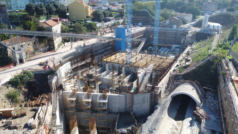
Facsa operates over 260 wastewater treatment plants, serving a population of more than 2.5 million people. The company provides clean drinking water daily to over 2,500,000 residents in more than 300 towns and cities.
Technology and innovation are pillars of the company’s strategy to address the challenges involved in delivering essential resources such as water, waste disposal services, and bioenergy—sectors that are critical to the well-being, development, and socioeconomic resilience of communities. In line with this commitment to innovation, Facsa began its GIS journey in 1986, but by 2020, it was clear a change was needed. “During the Smallworld era, there were five people [connecting] directly to the GIS using desktop software,” recalled Joan Pere Avariento Vicent, Facsa’s head of GIS. “[Staff throughout] the rest of the company had a thin client . . . but they didn’t use it because it was really slow and didn’t provide focused functionality”.
When Avariento joined the company in 2020, his first major challenge was to lead the transition from legacy GIS technology to ArcGIS and enhance the strategic use of GIS across the organization. While GIS had already been in place for years, it was primarily being used as a static repository of geographic data. “There was great potential to go further,” he explained. “Much of the interaction with GIS was limited to basic queries and printed maps, but the foundations were there.”
With Facsa expanding its operations across Spain and diversifying into new areas such as waste valorization and bioenergy, unlocking the full power of GIS became essential to support increasingly complex operations, optimize decision-making, and drive technological transformation across the company. Recognizing the untapped potential of Esri’s ArcGIS platform, Avariento launched a bold plan to modernize Facsa network information management capabilities and implemented ArcGIS Utility Network. This foundation allowed Facsa to innovate and create a role-based ecosystem of applications tailored to diverse operational needs. By 2022, Facsa had fully transitioned to ArcGIS Enterprise and completed the company-wide deployment of a technology called GIS Corporate.
A Role-Based, Integrated GIS Vision
One of Facsa’s guiding principles was to ensure that GIS technology served everyone—not just GIS experts. Of the 350 GIS users at Facsa today, only 7 are GIS professionals. The remainder are field crew members, engineers, inspectors, analysts, and managers—all empowered through intuitive, purpose-built applications that span a wide range of use cases:

- Smart metering solutions integrate with ArcGIS for spatial insights into water consumption.
- The Water Control Center app enables customer service to locate incidents in real time, assess affected areas, and generate automatic notifications.
- Outage dashboards offer live tracking and historical querying capabilities for nonoperational users.
- Work order dashboards integrate asset and incident data, enabling real-time assignment and asset-level reporting.
The strategic design of these tools reflects a fundamental belief. “GIS democratization means bringing GIS to water business experts, focusing on business needs and business cases,” said Avariento. “Return on investment, users’ point of view, and user experience must be a priority.”
GIS as a System of Systems
For Facsa, GIS is not just a visualization tool—it’s the connective tissue of the business. “GIS offers us a holistic vision of all of the management system data,” Avariento noted. Every component of the water cycle—capture, treatment, supply, consumption, and sewer—relies on data from siloed systems. But GIS brings those silos together.
By using geospatial data as a bridge, Facsa can now correlate upstream causes with downstream impacts, regardless of whether they originate in the same system. “We could have many systems and some data in Excel or something like that,” he explained. “But having different business data that’s happening in the same place is really powerful.”
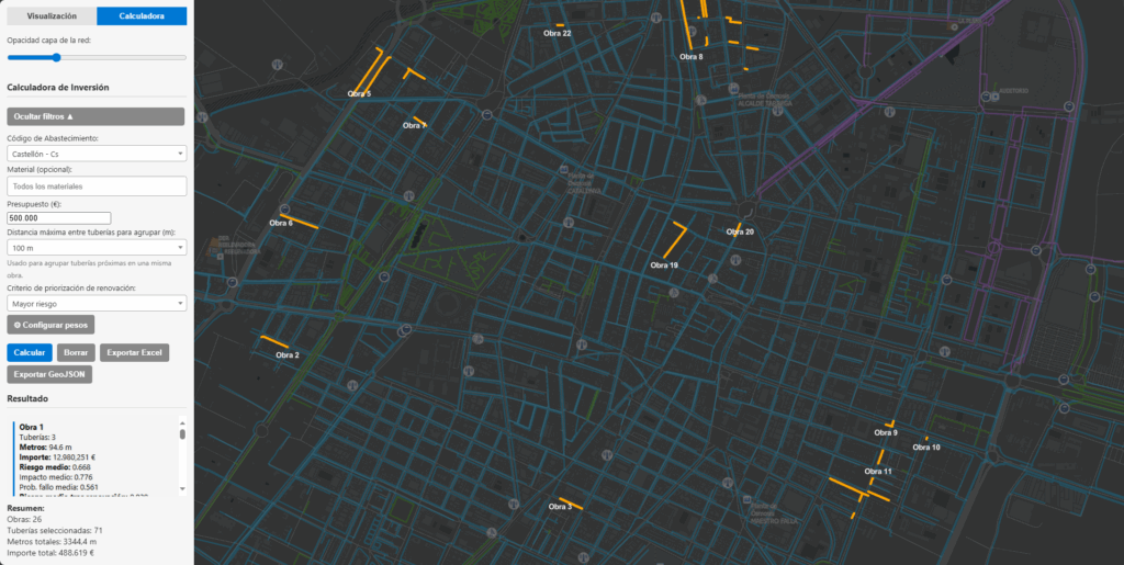
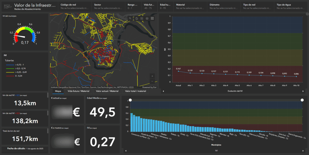
This geocentric approach is particularly valuable in asset management. Facsa evaluates infrastructure using two types of models:
- Life-cycle-based models that track asset performance, maintenance history, and age
- Geospatial impact models that assess criticality by analyzing environmental context, customer impact, and failure consequences
“GIS helps us calculate the impact—how critical is one asset, not just if it’s connected in the network but [also] how many customers would be affected, or what is around that pump,” he explained.
Digital Twins: From Vision to Execution
Facsa’s long-term road map is rooted in the development of a digital twin—a dynamic, data-driven replica of the company’s infrastructure. The digital twin goes beyond visualization; it enables forecasting, scenario analysis, and sustainable planning. For example:
- A digital twin of the aquifer allows Facsa to simulate how droughts or extractions might affect water quality.
- Odor dispersion models use integrated real-time sensor data and weather forecasts to plan optimal waste truck routes, minimizing impact on urban areas.
- Capital improvement plans include real-time integration with hydraulic models to enable what-if simulations directly within the GIS platform.
“GIS can become the system of systems that enables the creation of a digital twin to analyze and understand the behaviors of the network from a holistic perspective,” Avariento said.
Future-Focused and Limitless Potential
For Avariento, the most exciting part of working with ArcGIS is its creative potential:
Facsa’s GIS journey demonstrates how an organization limited by legacy technology can transform into a cutting-edge leader by placing spatial intelligence at the heart of operations. With ArcGIS Enterprise and ArcGIS Utility Network as Facsa’s technological backbone, the company has built a future-ready infrastructure capable of sustaining Spain’s water resources—and delivering measurable value—well into the next century.