Built on Esri’s ArcGIS system, the Federal Emergency Management Agency’s (FEMA) Resilience Analysis and Planning Tool (RAPT) gives emergency managers key data about their community, including population characteristics, infrastructure locations, and potential hazards. Understanding these elements of a community can lead to better preparedness, mitigation, and response strategies. Emergency management and disaster response planners are emphasizing understanding an area’s systemic risk to break the familiar cycle of respond, recover, and repeat.
Key Takeaways
- An increase in climate-related disasters drives the need for more accurate analysis, planning, and mitigation.
- Emergency managers gain access to data and maps for locating vulnerable people and infrastructure.
- Online FEMA tool gives community leaders access from any device and location.

A Comprehensive Perspective on Resilience
As the climate changes, more extreme and frequent disasters are hitting communities that haven’t previously had to deal with catastrophic emergencies. For instance, Tropical Storm Irene caused inland flooding in Vermont, destroying more than 100 iconic century-old covered bridges—structures not built to withstand a deluge of that force.
At the outset of this year’s hurricane season, which typically runs May through November, President Biden announced $1 billion in federal funds through the Building Resilient Infrastructure and Communities program, double previous amounts, to help communities increase resilience. Soon regional emergency planners must determine how to make the greatest impact with their community’s share of funding. They will work to understand local risks, see where mitigation projects would have the greatest impact, and figure out how to equitably address community needs.
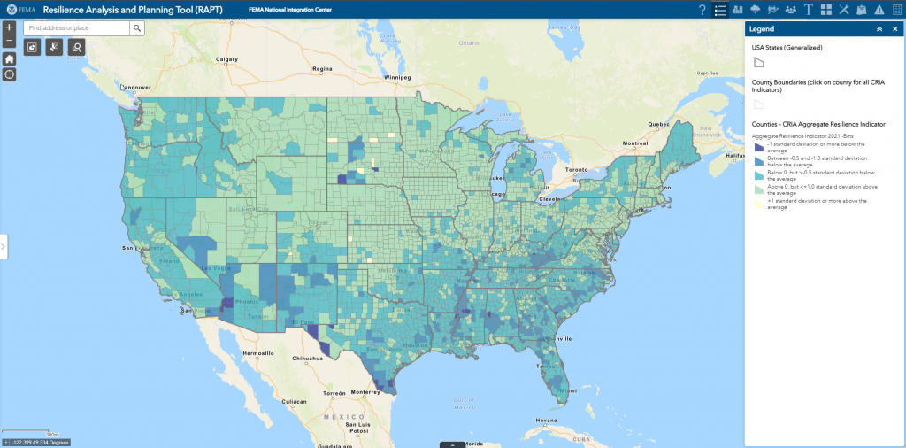
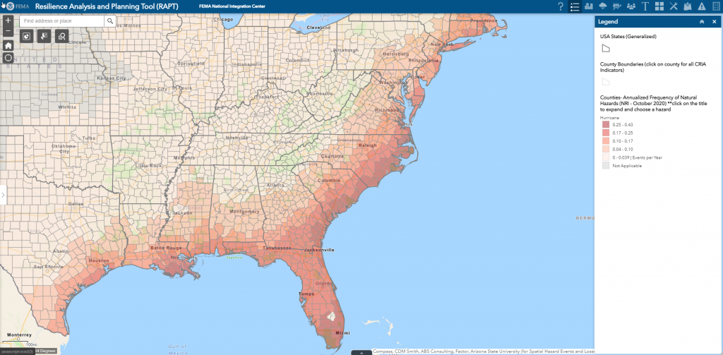
The data layers and analytical tools in RAPT empower planners to assess local risks and community vulnerabilities. RAPT provides emergency managers, community leaders, and policy makers with a visual picture of the community by layering hazard risk, population information, and critical infrastructure locations on a map to provide a more comprehensive perspective of resilience challenges.
Bringing Together Data and Analysis
Using RAPT, planners can analyze census and demographic data about people, critical infrastructure such as schools and hospitals, live weather feeds, and historical hazard impacts across space and time. The tool brings all the data together in one place where it can be visualized and analyzed, instead of having nine Excel data tabs open in a browser.
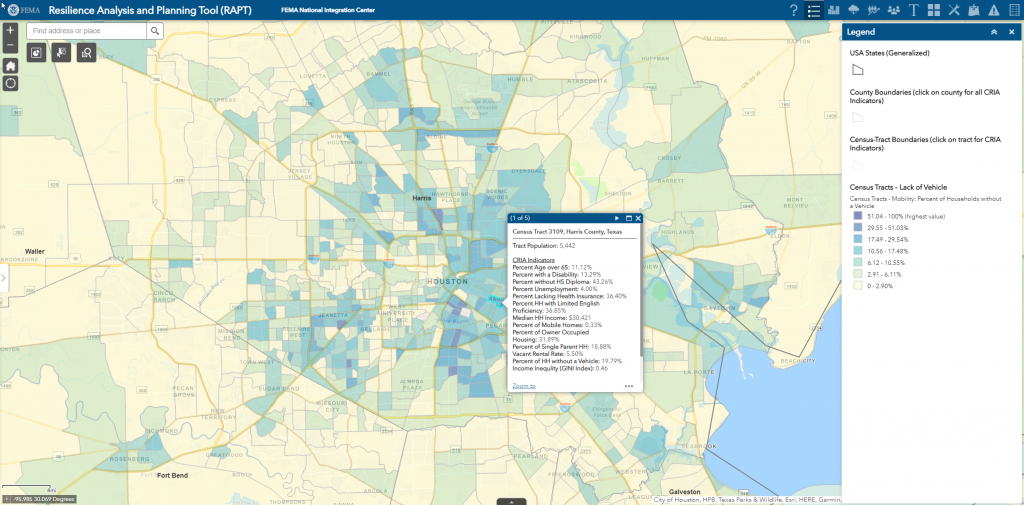
RAPT began with the Community Resilience Indicator Analysis, which identified the population and community characteristics that indicate a community’s challenges to resilience based on published, peer-reviewed research. These 20 community resilience indicators included people with disabilities, no access to a vehicle or the internet, or limited English proficiency. With that information, responders can compare needs against available resources, such as the number of buses and public transportation routes to conduct an evacuation or neighborhoods where it may be necessary to go door to door.
The RAPT interface is designed for anyone with pressing emergency questions. As a free, publicly available cloud-based geographic information system (GIS) application, it can be accessed on a desktop, laptop, tablet, or smartphone, making it useful anywhere decisions need to be made. The tool also allows for data downloads and uploads and delivers data as web services so it can be integrated into other decision support systems. Users don’t need a GIS background, and they can check and uncheck different parameters to see various aspects of their community. Once they start using RAPT, they can dive deeper with analysis tools to examine who and what might be impacted by different types of risks.
Supporting All Types and Sizes of Crisis
In places frequently struck by hurricanes or tornadoes, residents are generally more familiar with preparedness measures for those hazards. However, extreme storms brought on by climate change are also impacting communities unaccustomed to high winds or flooding. And emergency managers are increasingly tasked with responsibilities to coordinate response to natural, technological, and human-made hazards. In short, preparedness for all types and sizes of crises has become key to building resilience.
During the pandemic, for instance, leaders in many jurisdictions used RAPT to answer crisis response questions including those related to vaccine distribution. The experts at FEMA are hoping all communities will access the data and risk analysis functions of RAPT for a variety of initiatives.
Visit FEMA’s Resilience Analysis and Planning Tool web page for more information, including a user guide and how-to videos.
Building on a Foundation of Homeland Security Data
The Federal Emergency Management Agency’s (FEMA) Resilience Analysis and Planning Tool (RAPT) draws data layers from the Homeland Infrastructure Foundation-Level Data (HIFLD) that the US Department of Homeland Security first released in 2016. This resource is made available to all jurisdictions with both an open login for public information and a secure login for sensitive data.
Including HIFLD data in RAPT gives emergency managers a visual display of critical infrastructure locations in the community. If RAPT users identify any data points from HIFLD that are inaccurate, such as a new school that is not included or a hospital that has closed, RAPT includes a frequently asked questions section that directs users to send an email to HIFLD at HIFLD@HQ.dhs.gov to update the data point. This crowdsourcing from those on the ground who know firsthand about changes to infrastructure or facilities ensures that we all have the most accurate data source available.