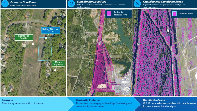
When the City of Chesapeake, Virginia, set out to modernize its emergency management operations, the team didn’t start by looking to buy another system. It started with a different question: How could Chesapeake make better use of the technology it already had?
That question brought emergency management and geographic information system (GIS) professionals together to rethink how the Emergency Operations Center (EOC) collects information, coordinates work, and communicates changing conditions to decision-makers.
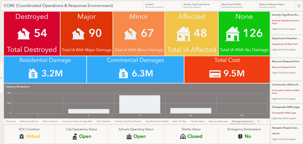
In less than a year, that idea became Chesapeake CORE, a familiar, ArcGIS software-centric operational environment built around the city’s existing technology, local processes, and the people who would use it during an activation.
The Problem: Technology Wasn’t the Issue—Usability Was
Chesapeake already had technology in place to manage incidents and events. The challenge was making those investments work for the people who needed to use them during emergencies.
Some systems were underused, while department leaders relied on an incident management platform they might open only once or twice a year. During an activation, that unfamiliarity created delays. “We spent a vast majority of our time training people on current systems instead of actually managing an incident,” said Robb Braidwood, coordinator of the City of Chesapeake Office of Emergency Management.
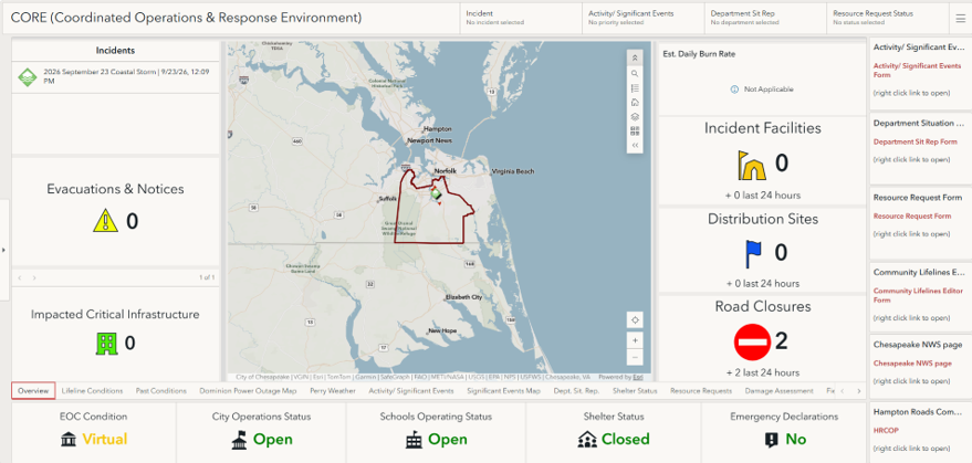
The problem went beyond training. Information needed to make operational decisions was spread across different tools and workflows, in systems owned and maintained by different organizations. Road closures, activity reports, resource requests, and communications were available, but leaders needed a faster way to understand what was happening in one integrated system. Flooded roads, closed bridges, power outages, and disrupted schools become more meaningful when viewed together geographically rather than pieced together from spreadsheets, reports, and individual updates.
At the same time, city leadership was encouraging departments to maximize existing technology investments. For emergency management, that presented an opportunity to rethink the problem. “The vision was a crisis management system that was more intuitive and built on something that everybody uses every day,” Braidwood said.
The Vision: Build Around What People Already Know
A visit to the nearby City of Virginia Beach Office of Emergency Management helped turn that idea into a practical vision.
Chesapeake’s team saw how Virginia Beach was using ArcGIS as part of its incident management environment and recognized that Chesapeake already had many of the same building blocks. Instead of introducing another disconnected application, the team could create an operational environment around tools employees already knew.
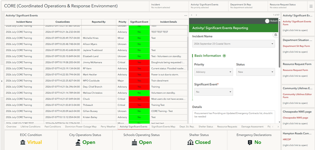
ArcGIS would provide a shared visual operating picture; ArcGIS Survey123 would support consistent data collection for situation reports, significant events, and resource requests; and Microsoft Teams would continue to provide familiar communication, collaboration, and calendaring capabilities.
The opportunity was not simply to replace an incident management application. It was to create an environment that reflected how Chesapeake actually operates: visually, collaboratively, and across departments, while leveraging a system and technology solution most organizations already used.
That vision became Chesapeake CORE.
“Developing CORE has been different in that the developers, subject matter experts, and end users are all within the organization, which gives us the ability to continually adapt the system to fit the needs of the organization. With most other systems, the developer is a contractor who builds the system, implements it with some training, and the system is what it is unless costly developer hours are used for modification,” said Robert Lee, senior planner, City of Chesapeake Office of Emergency Management.
Pair Curiosity with the Right Partnerships
Perhaps the most relatable part of Chesapeake’s story is who built CORE.
Emergency management staff often wear multiple hats, and Chesapeake is no different. The city has a dedicated GIS department, but emergency management also maintains its own GIS capabilities. Like many emergency management organizations, Chesapeake planners working on CORE were not formally trained GIS developers. They also balanced mitigation projects, operational responsibilities, and their everyday work.
That experience makes it particularly relevant to other jurisdictions.
The team learned how to navigate ArcGIS through Esri Training resources, books, online research, conference connections, and plenty of trial and error. They built, tested, and rebuilt configurations before asking for help. When they reached the limits of their knowledge, Chesapeake’s GIS program manager, Virginia Fowler, did more than fix the problem. She walked the planners through the solution so they could understand what had changed, build their own capabilities, and apply those lessons to the next challenge. Fowler also provided insight into how CORE could be expanded in the future with the implementation of other Esri products like ArcGIS Velocity.
That partnership became one of the project’s most important assets.
The lesson for other emergency management organizations is straightforward: You do not necessarily need a large development team to expand your use of GIS, but you do need relationships.
Build a strong partnership with your GIS professionals. Identify specialists who understand the applications you rely on. Develop relationships with peers who can serve as trusted technical resources. And give your team enough time and space to learn, test, and iterate.
“With each step, we learned we were just scratching the surface of what we could accomplish with Esri products. This drove us to keep trying new things; some worked, and some did not, but it made us keep trying to build a better system,” said Doug Crowson, senior planner with the Office of Emergency Management.
Configure Technology Around the Way You Operate
Another intentional decision made during the build-out of CORE was that Chesapeake did not recreate every function of its legacy incident management system.
Instead, the team started by identifying its most-used capabilities, deployed the ArcGIS Emergency Management Operations solution, and evaluated how its configurable applications could support those requirements. Where gaps existed, the team adapted the environment to fit how Chesapeake staff accomplishes their work.
Development happened through short feedback cycles with stakeholders: demonstrate a draft, gather input, adjust the layout or functionality, and test again. That iterative approach kept the technology focused on operations rather than forcing operations to conform to a generic system.
Go-Live: A Beginning, Not an Ending
After roughly a year of development, Chesapeake launched CORE ahead of the 2026 hurricane season and began training departments and stakeholders. Early feedback centered on one of the project’s original goals: usability. Instead of asking occasional EOC users to relearn an unfamiliar system every time an incident occurred, CORE gave them an environment built around ArcGIS, a familiar, easy-to-use collaboration tool.
But Chesapeake is not treating the launch as the finish line. The next phase is about expanding the common operating picture, not simply adding more technology.
CORE is designed to evolve as operational needs change. The team is moving the user experience to ArcGIS Experience Builder to provide greater flexibility and plans to use ArcGIS Velocity to incorporate real-time data feeds from systems such as supervisory control and data acquisition (SCADA) and computer-aided dispatch (CAD).
From Existing Investment to Operational Value
Chesapeake’s experience demonstrates that modernization does not always mean starting over. Sometimes it starts with asking better questions:
- What do we already have?
- What do our people actually need?
- Where does technology create friction or delay?
- And how can we design around the way people work when the pressure is on?
CORE is more than a new way to see information. It shows what can happen when technology is configured around the people, processes, and decisions that matter most during an emergency. Chesapeake’s experience also shows that modernization doesn’t always require starting over. It can start with a clear understanding of operational needs, an honest inventory of existing capabilities, and a commitment to designing for the people who will use the system under pressure. By pairing emergency management expertise with GIS support and learning through disciplined iteration, a small team created a common operating picture that works today and can scale for what comes next.