Challenge
MGN Civil is an Australian based marine civil construction company with expertise in large-scale civil engineering. Traditionally a company focused on the physical movement of materials, excavators, and heavy equipment, MGN Civil recognized that the construction industry was entering a new era. Shrinking margins and growing project complexity demanded a shift toward what the company describes as the “digital construction site.”
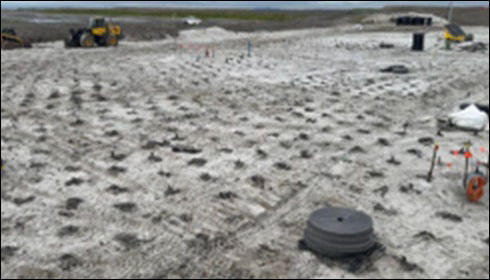
MGN Civil is delivering a large-scale ground improvement program at the Port of Brisbane to support drainage and long-term stability on reclaimed land. The work involves drilling wick drains (narrow plastic strips approximately 25 meters deep) across an expanding grid of holes spaced approximately 1 meter apart. To meet contract specifications, each hole must reach a geologically defined layer called the Holocene, a clay stratum that varies in depth from 18 to 30 meters. Trimble RTK GPS devices mounted on the drilling rigs capture precise location data alongside telemetry including penetration rate and percussion, producing two XML files per hole. With rigs operating 24 hours a day, seven days a week, the volume of data was continuous and substantial.
The existing process could not keep pace. Field teams were required to manually download the XML files, process them through Excel macros, and validate the results against compliance standards. This process consumed the time of two team members for up to six hours every single day and was prone to errors, particularly when macros failed or produced inconsistent outputs. More critically, when an error was identified, the discovery could come two to three weeks after the fact. By that point, the 30-tonne drilling rig had since moved on, requiring a costly and time-consuming repositioning to correct any non-compliant holes.
The scale of the problem was clear. Every layer of the workflow, from data extraction to manual validation to late-stage error detection, was adding risk, rework cost, and operational inefficiency to a project that required precision at every step.
Solution
MGN Civil partnered with Locus, an Esri and Safe Software partner, to redesign the entire data pipeline using FME and ArcGIS. Working iteratively and in close collaboration with both field staff the team developed an event-driven, geospatial pipeline capable of ingesting, validating, and publishing every hole automatically.
The architecture is built around two FME workspaces, each handling a distinct stage of the workflow. The first workspace, responsible for ingest and validation, reads XML data directly from Trimble Connect Cloud, parses telemetry, and reprojects geometry from the local field coordinate system to the required target CRS. It validates each hole against location, depth, and compliance rules before loading the result into a File Geodatabase as the system of record.
FME proved especially valuable in resolving coordinate challenges that would otherwise have stalled the pipeline, FME handled the reprojection cleanly, and a device output error that reversed X and Y coordinates was resolved through the same toolset, ensuring location data was reliable from day one.
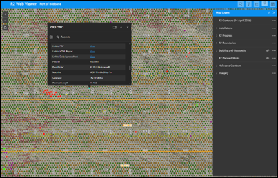
The second workspace handles all reporting and publishing. It generates standardized Excel outputs for regulatory compliance, builds a one-page PDF per hole complete with sensor graphs, and pushes outputs to Amazon S3 for immediate field access. The same workspace refreshes an ArcGIS Online Map Service, feeding a suite of visualization tools accessible to both MGN Civil staff and the client.
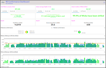
On the ArcGIS Online side, the team deployed ArcGIS Dashboards for daily and rolling KPIs covering holes drilled, passed, flagged, and missing. ArcGIS Experience Builder web applications provide near-real-time maps where every hole is plotted and symbolized by compliance state using a standard traffic light color system. ArcGIS Field Maps gives crew chiefs and inspectors tablet access in the field, allowing them to navigate directly to flagged holes and investigate issues on the ground without waiting for a report.
A deliberate design decision shaped how information is shared with the client. Rather than pursuing second-by-second alerts, the team adopted an “in time” philosophy, delivering information at the point when it can be acted upon rather than attempting to stream it in real time. Both an internal view for MGN Civil management and an external view for stakeholders were configured within ArcGIS Online, giving the client a single portal to access current and historical data, linked directly to per-hole PDFs and spreadsheets through the Experience Builder interface.
The solution was developed using an agile delivery method, with MGN Civil field staff contributing observations throughout the build. That collaborative approach ensured the final system reflected real operational constraints rather than assumed requirements.
Results
The operational impact was immediate and measurable. What had consumed two team members for four to six hours every day now completes in minutes. Non-compliant or missed holes are identified and corrected before equipment moves on, eliminating the costly rework cycles that had previously defined the project.
Beyond raw efficiency, the system has materially improved compliance rates and accelerated decision-making at every level of the project. Crew chiefs can review conformance status from a tablet in the field. Project managers have rolling KPIs updated in near real time. The client, previously receiving data days after the fact, now monitors progress through a dedicated portal that surfaces both current performance and historical records.
The transparency that the system enables has also reshaped the commercial relationship. MGN Civil had initial concerns that surfacing errors in real time could damage client confidence. In practice, the opposite occurred. The client’s ability to see issues as they arise, alongside the evidence of how those issues are resolved, has generated a significantly higher level of trust.
The project has also become a template for the company’s broader growth strategy. Components of the FME and ArcGIS Online pipeline are already being adapted for other projects and workflows, including material volume tracking via electronic weighbridge data and visual KPI dashboards. MGN Civil now brings the geospatial workflow into tender meetings as a competitive differentiator, demonstrating to potential clients from the outset that the company can deliver not only physical results but also the real-time data visibility and accountability that large-scale infrastructure projects demand What began as a single ground improvement pilot has become the foundation of how MGN Civil defines its value to the market.
Learn more about location intelligence for AEC:
GIS for Architecture, Engineering, and Construction.
Stay Connected with Esri’s AEC Team:
Subscribe to the AEC industry newsletter “Esri News for AEC”.