Customer Spotlight Story
Arizona Public Service (APS) is the largest electric utility in Arizona, serving approximately 1.4 million homes and businesses across the state. Its service territory spans roughly 35,000 square miles, covering a diverse mix of urban, suburban, and rural communities, including the Phoenix metropolitan area. APS aims to provide reliable energy to support Arizona’s growth while keeping customer bills as low as possible.
APS pioneered geographic information system (GIS) technology in 1994 by migrating its paper circuit maps to Esri’s GIS. It has been a leader in the GIS community since then.
CHALLENGE
Wildfire dangers have increased across the western United States. Fires are no longer rare, seasonal threats but are fast becoming a year-round, nationwide crisis. Additionally, the utility industry is experiencing rapid changes in customer technology and behaviors, increased intensity and impacts of extreme weather, and increasing costs of aged assets and system upgrades. As Arizona’s largest electricity provider, APS knew it couldn’t afford to wait; the challenge was too great for the communities it serves.
The solution was clear: step up wildfire mitigation efforts, leverage smart grid technology, and improve grid resilience. But that takes investment. The Infrastructure Investment and Jobs Act (IIJA), signed in November 2021, and one of its key programs, the DOE-administered GRIP (Grid Resilience and Innovation Partnerships), provides matching funds to modernize the electric grid—making it more resilient, reliable, and equitable in the face of climate threats.
The challenge for APS: How to beat the 5% odds of winning a GRIP grant.
SOLUTION
It would be more than spreadsheets and statistics. APS had to turn its urgency into an impactful, memorable, compelling story.
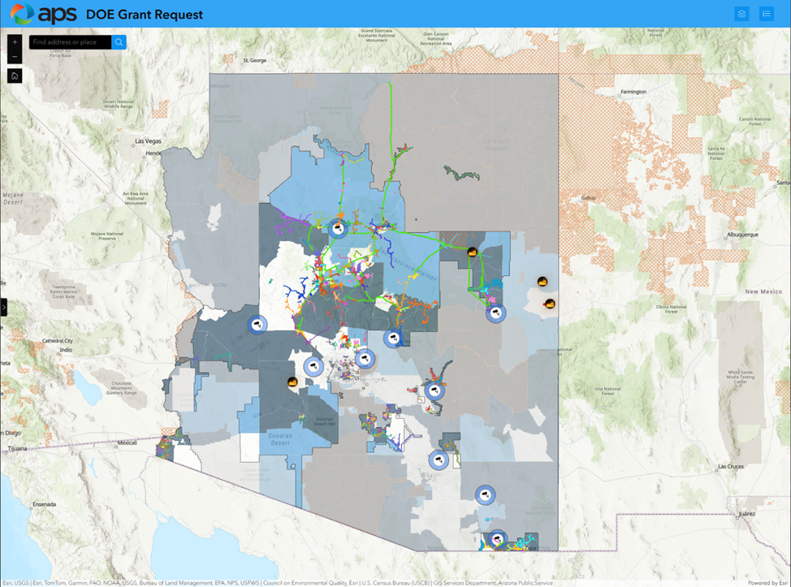
APS relied on this sophisticated GIS modeling of its electric network to assess risk.
One requirement stood out: the investment’s benefits had to serve communities directly. It wasn’t enough to submit tables of numbers or abstract statistics. APS needed to make the benefits real, visible, and personal.
“To beat the odds, we knew we had to create a visual personal story that created ah-ha moments. That’s where GIS became a game-changer.” Neil Traver, Federal Funds Program Manager, APS
Instead of relying solely on data points in a spreadsheet, APS used GIS spatial analysis to build a compelling visual narrative. The utility could clearly show where the impact would land by layering maps of grid infrastructure, such as circuits targeted for wildfire mitigation and resilience upgrades. The story wasn’t about lines and poles—it was about people.

APS used various data sets and layers to show where the circuit hardening would occur.
By leaning into the power of GIS, APS transformed its grant application into a vivid, human-centered story—turning infrastructure and policy into relatable impact. The maps didn’t just support the narrative. They were the narrative.
RESULTS
In October 2024, the U.S. Department of Energy (DOE) awarded APS two grants totaling $160 million under the GRIP program. The federal portion was $70 million; the remaining was funded by APS.
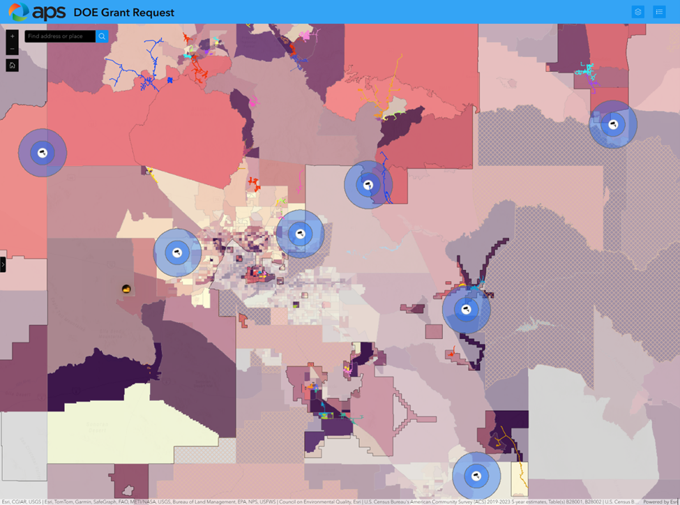
APS used GIS to determine the risk through a community lens.
One of the grants to strengthen APS’s wildfire mitigation efforts included:
- Upgrading Infrastructure: Replacing select wooden poles in high-risk fire areas with fire-resistant steel poles.
- Enhancing Monitoring Systems: Expanding the network of weather stations and fire-monitoring cameras across Arizona’s high-fire-risk areas.
- Developing Microgrids: Constructing microgrids in high fire risk communities
These efforts complement APS’s existing wildfire mitigation strategies, such as clearing hazardous vegetation from approximately 40,000 power poles annually and coordinating with local fire agencies on emergency response plans.
In addition to its success on the wildfire mitigation grant, APS leveraged GIS to win its Deploying Smart Grid Technology to Enhance Arizona’s Resilient Grid grant. That grant focused on rural communities to increase their resilience to electric supply disruptions. The work included installing smart grid devices, developing advanced operational applications, increasing transmission capacity, and transforming field telemetry data into actionable intelligence to better serve Arizona communities.
APS leveraged GIS to create detailed, layered maps visually demonstrating the project’s impact. By overlaying planned infrastructure enhancements with geographic data of rural areas, APS effectively illustrated how the proposed improvements would directly serve these communities. This spatial analysis highlighted the alignment between the project’s objectives and the needs of different regions, emphasizing APS’s commitment to resilient and reliable energy. In both awarded grants, the visual storytelling facilitated by GIS allowed APS to move beyond abstract statistics, presenting a clear and relatable picture of the project’s benefits. This approach strengthened their grant application and underscored the tangible advantages for Arizona communities, reinforcing the case for federal support.
“GIS has been integral to our forestry and fire mitigation efforts for years. Our Advanced Grid Technology team has been exploring ways to visualize their story with GIS. We are now witnessing a natural culmination poised to deliver significant, tangible benefits to our community.” Rami Alygad, Manager of Smart Grid & GIS
BENEFITS
The grant application leveraged the Department of Energy’s Interruption Cost Estimate Calculator to determine the benefit of improving the resilience of the electric network. The determination was that the savings in APS’s emergency response would far exceed the cost of the resilience improvements over 20 years. In addition, aside from APS cost savings, individual customers would benefit from fewer and shorter outages.
Aside from the benefits of winning the grants, APS is now leveraging the grant process and advanced GIS spatial analysis in its normal planning and operations.
NEXT STEPS
As the projects are finalized and rolled out over the next five years, APS will leverage GIS to demonstrate compliance with the GRIP’s strict documentation processes using maps and GIS dashboards.
“We’ve come a long way. GIS used to be just a record of where assets are and how they connect. Today, it is an enterprise system of insights that continues to become more important in building the grid of the future.” Tony Tewelis. SVP of T&D Operations, APS
SUMMARY
Challenge: APS needed to overcome long odds to secure a DOE GRIP grant while addressing growing wildfire risks, aging infrastructure, and increasing demands for grid resilience across Arizona.
Solution: APS used GIS spatial analysis and layered mapping to create a compelling, community-focused visual story that demonstrated how proposed grid upgrades and wildfire mitigation projects would directly benefit Arizona residents.
Results: APS was awarded two DOE GRIP grants totaling $160 million to support wildfire mitigation, smart grid modernization, and resilience improvements for rural and high-risk communities across Arizona.
Benefits: The GIS-driven grant strategy helped APS secure major funding, reduce projected outage and emergency response costs, improve customer reliability, and integrate advanced spatial analysis into ongoing utility planning and operations.