A Customer Spotlight
Guadalupe Valley Electric Cooperative (GVEC) is a cooperative based in South Central Texas. It provides electric, internet, and beyond-the-meter services to over 100,000 electric customers, and around 30,000 internet customers across 13 counties. GVEC’s primary services include reliable electricity and advanced internet solutions, making it a vital utility provider in the region. With a service area spanning over 3,500 square miles, GVEC is committed to delivering efficient and innovative services to its customers.
Challenge
GVEC faced significant challenges in managing easements. The goal was to improve the recording and tracking of easements by the real estate and right-of-way teams. The utility sought a user-friendly and visual way to input new easements, adjust the status of existing ones, and store associated documents. The data was previously entered into another application, not directly into its GIS, leading to complicated integrations and a lack of clarity. This resulted in inefficient resource utilization and slow project processing. Moreover, the existing solution was becoming obsolete. The cooperative needed a more streamlined and integrated approach to easement tracking that would align with its overall GIS strategy.
Solution
To address these challenges, GVEC implemented a GIS solution using ArcGIS Experience Builder within ArcGIS Online. Experience Builder provided a very customizable look and feel, requiring little coding. GVEC also utilized ArcGIS Survey123 by embedding a widget within the Experience Builder application, enabling users to input attributes and adjust easement geometry. This solution was chosen for its seamless integration with GVEC’s existing GIS data and its cost-effectiveness.
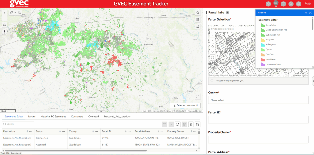
Now, project processing and real estate groups enter and update easements directly within the app, replacing the previous third-party solution. This was an easy transition given their familiarity with other ArcGIS web applications. When the real estate staff receives a signed easement, they can easily locate the associated parcel. The app populates the basic parcel information, and the user inputs the specific easement information. Users may edit the easement geometry within the map. New easements are immediately visible on the maps, and status changes are readily noted.
The implementation process involved several key steps:
• Stakeholder Engagement: GVEC met with stakeholders from the project and real estate teams to determine their needs.
• Planning and Design: The cooperative went through an extensive planning process, researching various technologies to determine the best tools for their use case and consulted with Esri Solution Engineers.
• Solution Development: GVEC designed the solution, focusing on the ArcGIS Experience Builder application and the embedded Survey123 widget. It also added historical data and functionality, including a print layout.
• Testing and Feedback: Stakeholders tested the app and provided feedback. GVEC made the necessary adjustments, improving the application’s speed by updating its parcels layer to a hosted feature layer published to ArcGIS Online.
The cooperative currently uses ArcGIS as the system of record for spatial data across the organization. GVEC’s current implementation consists of ArcGIS Enterprise, ArcGIS Online, and ArcGIS Pro. It has approximately 200 GIS users across its organization.

Results
The implementation of the solution brought significant improvements for GVEC:
• Streamlined Workflow: Project processing and real estate teams now directly enter and update easements within the app, simplifying the process and reducing unnecessary data entry. These improvements save staff time and improve service levels. The new workflow allows users to search for parcels or addresses associated with easements, input specific easement information, and edit easement geometry within the map.
• Cost Savings: GVEC estimates savings in the tens of thousands annually by developing and hosting the solution internally, and eliminating additional third-party licensing costs.
• Improved Efficiency: The new solution reduced the time spent on easement data management and analysis, thanks to a cleaner schema and simplified data handling. Users now easily view easement data on a map and in tabular form, facilitating better decision-making.
• Enhanced User Experience: Users praised the solution for its ease of use, added functionality (such as PDF upload and embedded links), and the ability to manage easements in-house. Users appreciate quicker response times, simplified data management, and immediate visibility on a map.
GVEC’s managers and executives view the solution as a viable and efficient tool for easement tracking and have already shared the solution with several other peer cooperatives. The utility plans to expand this implementation by scrubbing historical data to match the new schema and further customizing the printing layout for organization-branded templates.
By adopting the solution, GVEC streamlined its easement tracking process and set a precedent for other cooperatives to follow, driving efficiency and innovation in the utility sector.