Customer Spotlight Story
Heart of Texas Electric Cooperative (HOTEC) has served rural communities across Central Texas since 1937. Today, the cooperative supports more than 19,000 members across over 25,000 meters and nearly 4,000 miles of electric line throughout a geographically large and weather-sensitive service territory. Operating in a region prone to severe storms, extreme heat, and rapidly changing load conditions, HOTEC places a strong emphasis on reliability, resiliency, safety, and affordability for its members.
The cooperative’s infrastructure and operational responsibilities have expanded significantly over time, especially following the consolidation of McLennan County Electric Cooperative and Belfalls Electric Cooperative in 2007. As the system grew, HOTEC needed better visibility into grid operations and planning data while continuing to maximize the value of its existing technology investments.
CHALLENGE
HOTEC’s legacy systems supported specific business and engineering functions, but they lacked integration. Important data was distributed across GIS, AMI, SCADA, CIS, fleet systems, and engineering analysis tools, creating operational silos and limiting visibility between departments.
Like many utilities, HOTEC relied on multiple operational and engineering systems that performed individual functions well but were not designed to work together seamlessly. Engineering, planning, and operational data were stored across separate applications, making it difficult to maintain a consistent system model, run studies efficiently, or provide teams with a shared operational picture.
Engineering teams often had to move distribution models between multiple software platforms to complete studies, work plans, and planning evaluations. This process consumed valuable engineering time, increased the risk of inconsistencies between models, and made it difficult to maintain a single trusted representation of the system.
“Our goal was to bring our software products under one hood so we could get better engineering data and a more complete view of the system.” – Brandon Young, General Manager, HOTEC
The cooperative needed a solution that could unify data, streamline workflows, improve system visibility, and support long-term planning decisions — all while preserving the tools and operational processes that were already delivering value.
SOLUTION
HOTEC partnered with Electric Power Engineers (EPE) to deploy ENER-i as a centralized platform for distribution planning, engineering analysis, and operational visibility. Rather than replacing core utility systems, ENER-i was implemented as a cloud-based integration layer that connected critical utility data sources into a unified environment.
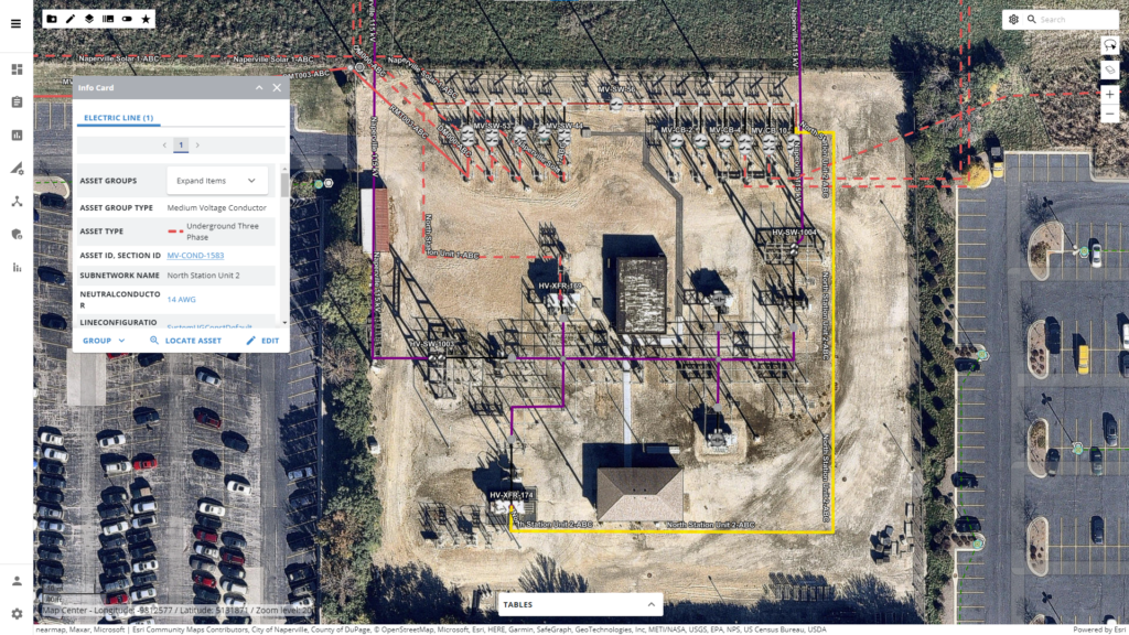
ENER-I integrated with ArcGIS enhances planning, engineering and operations.
Using ENER-i, HOTEC integrated GIS, AMI, SCADA, CIS, fleet location, and engineering analysis data into a single operational model supported by native Esri GIS technology. This allowed engineers and operational teams to work from a more complete and trusted representation of the grid while visualizing data through intuitive, map-based workflows.
The platform enabled HOTEC to conduct end-to-end engineering studies in a single environment, rather than transferring models between disconnected tools. By automating data preparation and model management, ENER-i reduced manual effort and improved consistency across planning activities.
“In the past, we had to use other engineering analysis software to complete the full work plan. With ENER-i, more of that work can now be completed within the same model, and the value of that work continues beyond a single project.” – Brandon Young, General Manager, HOTEC
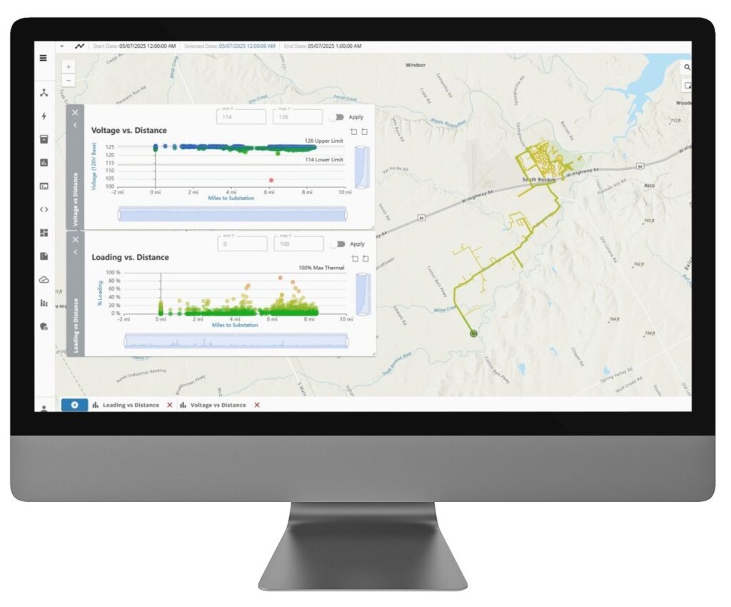
Built on the industry-standard OpenDSS simulation engine and tightly integrated with Esri GIS mapping, ENER-i enables HOTEC to run hundreds of simulations faster while maintaining visibility into each stage of the planning process. Engineering teams can now evaluate mitigation options, validate results, and communicate findings more effectively across departments and leadership teams.
The implementation was also highly collaborative. HOTEC worked closely with EPE to help shape the platform’s evolution based on real utility operational requirements and engineering workflows.
“When a utility helps an engineering and software team develop a tool, that tool is more likely to accomplish what the utility needs to do business efficiently. That’s been an important part of the value of ENER-I for HOTEC.” – Brandon Young, General Manager, HOTEC
RESULTS
By consolidating planning workflows and integrating operational data into a unified platform, HOTEC significantly improved visibility into its distribution system and reduced manual engineering bottlenecks.
Engineers now spend less time preparing and transferring data between systems and more time evaluating planning scenarios, mitigation strategies, and long-term investment decisions. The organization also benefits from a more consistent system model that improves confidence in planning studies and operational analysis.

Power systems expertise combined with Esri maps.
With Esri GIS visualization integrated directly into the workflow, departments across the cooperative can access clearer system information, communicate more effectively, and align around planning outcomes using the same trusted data.
The ability to run large volumes of simulations more efficiently has improved planning responsiveness and helped leadership evaluate infrastructure priorities, resiliency initiatives, and capital investment decisions more effectively.
PARTNER
EPE supported HOTEC with both enterprise software implementation and deep utility engineering expertise. With more than 50 years of utility engineering experience and a growing software development practice, EPE helped HOTEC modernize its distribution planning environment in a practical and scalable way.
By combining cloud-based analytics, utility data integration, and native Esri GIS capabilities, EPE delivered a solution that built on HOTEC’s existing technology investments while improving operational efficiency and planning insight. The partnership between HOTEC and EPE also helped shape the continued evolution of ENER-i, ensuring the platform reflects real-world utility planning and operational requirements.
The partnership between HOTEC and EPE also helped shape the continued evolution of ENER-i, ensuring the platform reflects real-world utility planning and operational requirements.
BENEFITS
By implementing ENER-i with ArcGIS integration, HOTEC gained a more connected and efficient approach to distribution planning and operational visibility. Instead of relying on disconnected systems and manual data transfers, teams across engineering, planning, and operations can now work from a unified system model supported by shared GIS-based visualization and integrated utility data.
The platform reduced time-consuming manual data preparation and eliminated many of the workflow bottlenecks associated with moving models between separate engineering tools. Engineers can now spend more time evaluating planning scenarios, resiliency strategies, and mitigation options rather than preparing or reconciling data. At the same time, the organization benefits from greater consistency and accuracy across engineering studies, operational analysis, and long-term planning activities.
Operations leverages ENER-I with ArcGIS
With ArcGIS as the visualization foundation, HOTEC improved cross-departmental collaboration by giving teams a clearer, more intuitive view of system conditions and planning results. Leadership and operational stakeholders can more easily understand engineering findings, align around priorities, and make better-informed capital investment decisions using trusted, map-based insights. Just as importantly, HOTEC was able to modernize without replacing the systems and technology investments already in place. ENER-i created a scalable planning environment that supports future system growth, increasing operational complexity, and evolving member expectations while strengthening the cooperative’s ability to improve grid reliability, resiliency, and long-term operational efficiency.
NEXT STEPS
HOTEC continues to expand its use of ENER-i to support broader operational awareness, long-term distribution planning, and data-driven decision-making across the cooperative.
As member expectations and grid complexity continue to grow, HOTEC plans to build on its integrated GIS and analytics foundation to further improve reliability, resiliency, and planning efficiency while supporting the cooperative’s long-term modernization strategy.
SUMMARY
Challenge: HOTEC’s engineering and operational data were spread across disconnected systems, limiting visibility, creating workflow inefficiencies, and making it difficult to maintain a consistent view of the grid.
Solution: HOTEC partnered with EPE to implement ENER-i with ArcGIS integration, creating a unified platform that connected GIS, AMI, SCADA, and engineering data into a single operational and planning environment.
Results: By consolidating planning workflows and automating data integration, HOTEC improved system visibility, accelerated engineering studies, and enabled teams to make faster and more informed planning decisions.
Benefits: Together, the integrated ENER-i and ArcGIS platforms improved collaboration, reduced manual effort, enhanced confidence in engineering analysis, and created a scalable foundation for long-term grid modernization and resiliency planning.

