We are at a crucial moment in the history of planet Earth. To conserve and protect our natural world in the face of climate change, we must invest in the future generations of humans, plants, and animals alike. Establishing protected areas, engaging with diverse communities to ensure equitable conservation actions, and utilizing geospatial technologies like ArcGIS are essential for preserving biodiversity, natural lands, waters, parks, and more.
One of the best ways we can stop the loss of species and start working toward a sustainable world is by educating diverse stakeholders, policy leaders, and community advocates about the importance of protecting the places we love—the places that matter the most for nature and human well-being. How do we protect the species, land, water, and food systems that sustain us? What tools are needed? What innovative approaches are already working? To help advise these crucial efforts, Esri has teamed up with conservationist and geospatial designer Breece Robertson.
Understand, Invest, and Strategize

The Esri Press team, in collaboration with Breece Robertson, has released both an ebook and print version of Protecting the Places We Love: Conservation Strategies for Entrusted Lands and Parks. This highly anticipated book focuses on how geospatial technology can assist in protecting special places that are in danger of being changed or lost forever.
The urgency of ensuring that these extraordinary places are saved cannot be overstated. It is essential that humans employ bold conservation strategies to boost land protection in all corners of the world. This requires that we understand the significance of equity; engage with historically excluded communities; and leverage the power of geographic information system (GIS) technology, such as ArcGIS, to determine which communities and areas of biodiversity around the world could be most impacted by the effects of climate change and are therefore most critical to protect.
In this book, Breece Robertson applies her experience, resources, and examples to illustrate a vision for success and provide guidance for current and future conservation groups. The goal of the strategies that Robertson lays out in this book is to support species; habitats; natural resources; and healthy, livable communities that are climate resilient while remaining socially cohesive (at relatively low costs). The book makes it clear that in order to create a more resilient, sustainable planet, we must first protect the natural places we love. This requires conservation planning, financing, equitable stakeholder engagement, and—most importantly—the implementation of current and future geospatial technologies to assess and monitor the areas that are most at risk and worth protecting.
Leverage Technology in Meaningful Ways
Protecting the Places We Love provides readers with insight into identifying places that need protection, and tells how to engage communities and leverage partnerships and geospatial technology—all in the effort to produce meaningful and impactful results in the years to come. The book helps readers learn about the effective tools for integrating existing practices with geospatial data and modernized applications based on real case studies from leading conservation organizations.
Maps have the power to inform and tell a story. Sharing one’s imagination and stories through technology like ArcGIS StoryMaps gives users the ability to bring people together, inform stakeholders, and visualize where to begin targeted action plans.
“[Robertson’s] work over the last two decades put down major footprints of progress.”—Jack Dangermond, Owner and President of Esri
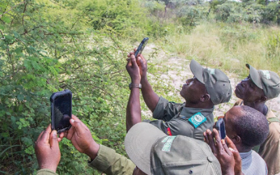
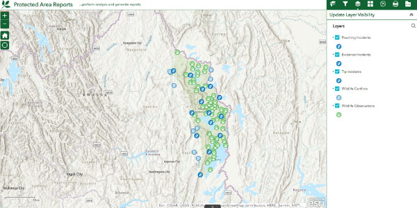
With Robertson’s guidance, the reader will be able to learn how to analyze park system access equity; map, model, and analyze land characteristics to enhance biodiversity, connectivity, and climate resilience; create maps that tell dazzling stories; and gain insights for fund-raising, policy, finances, advocacy, and more. Leveraging technology like ArcGIS Online, ArcGIS QuickCapture, and ArcGIS Solutions for Conservation allows endless opportunities for users to implement their conservation strategies by visualizing the very data being collected.
Explore Balance and Biodiversity with Breece Robertson
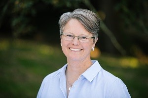
Breece Robertson, renowned conservationist and geospatial designer, has more than 20 years of experience in leading and building strategic initiatives. Robertson combines planning, extensive research, and groundbreaking technologies—including ArcGIS Online—to help support landscape conservation, environmental land management, and park infrastructure improvements. Robertson is currently employed through the Lincoln Institute of Land Policy, where she is able to carry on her meaningful work.
Robertson joined Esri’s Jack Dangermond for an interview regarding the launch of the book Protecting the Places We Love: Conservation Strategies for Entrusted Lands and Parks.
JD: What caused you to write this book? What does it contain?
BR: This really couldn’t come at a more important time in our history. We’re at a critical juncture, where we must save 30 percent of the earth’s lands and waters by 2030, and 50 percent by 2050, to avert catastrophic biodiversity loss and climate collapse. And we can’t do that without GIS! Our lives really do depend on saving the places that we love. And, number one, we need to know where those places are—what 30 percent, what 50 percent. And we also need a common language and a platform to connect all of the great work that is going on around the world towards these very challenging goals. We can’t do it without data, science, and geospatial technologies.
JD: Is this book really to support your work or help other people understand the methods that you developed, or understand the context? What exactly do you have in mind here?
BR: The book is really a call to action, but it’s also really a culmination of my experience at The Trust for Public Land. I give practical examples and strategies on how to do certain things—how to map, model, and analyze certain topics like climate reliance [and] large landscape conservation. The main goal of the book is to really let everybody know that these tools and technologies are not out of reach and that we all can be using them, whether it’s around advocating for a park down the street or protecting 20,000 acres of natural habitat that needs to stay intact.
View the full interview between Jack Dangermond and Breece Robertson.
Join the Movement
Investing in geospatial technologies for the conservation of natural lands is a movement many relate to. GIS is a key component in learning which areas are most in need of protection, understanding the effects of climate change on underrepresented communities, seeing how to live in harmony with nature, and prioritizing what areas humans are encroaching on. Through examples and thorough research, Breece Robertson demonstrates how it is possible to utilize geospatial technologies for these causes.
Protecting the places we love is crucial to continue toward a sustainable, more harmonious future for all life on earth. The book emphasizes the importance of protecting areas of biodiversity and natural lands to support species; habitats; natural resources; and healthy, livable communities. Many nonprofits, governments, and organizations have started to enact more sustainable choices, and this is only the beginning.
“You can’t have conservation if you don’t also have equity in social and environmental and racial justice.”—Breece Robertson, Director of Partnership and Strategy, Center for Geospatial Solutions, Lincoln Institute of Land Policy
To learn more and purchase Protecting the Places We Love: Conservation Strategies for Entrusted Lands and Parks, please visit Esri Press, Amazon, or Barnes & Noble.
To learn more about Esri technologies for conservation, view our overview page.